
Home » Regions » North America » Marine West Coast Forest » Cook Inlet
Cook Inlet
Last updated: February 29th, 2024
Page contents
↑About the Cook Inlet
The Cook Inlet is a lowland region in south-central Alaska surrounding the body of water with this name and extending inland slightly to the north. Anchorage is located here along the east-central portion of this region.The climate here is among the mildest anywhere in Alaska other than the regions directly bordering the Pacific, and is usually described as a subarctic climate with strong oceanic influence and slight continental influence. The tall mountains to the east, west, and north provide shelter from Arctic air and continental influences. The large area of water in this sheltered space, opening to the ocean to the south, and the Pacific ocean currents bringing warmer waters from farther south, all combine to moderate the local climate. Precipitation here has a seasonal delay, peaking much later than temperatures, with August and September being rainiest, but July being warmest; by contrast April through June are much drier. Winter brings significant snowfall. Occasionally, this region can experience ash deposition from active volcanoes nearby.
The terrain ranges from almost entirely level to gently-rolling hills, although there are a few isolated low mountains, the largest of which is Mount Susitna. With the exception of the isolated mountains, the terrain tends to be slightly hillier around the margins of the region and flatter in the interior and approaching the water. Soils here tend to be rich in both organic matter and mineral nutrients, and are unusually fertile for a region so far north. Most of this region is free of permafrost. The hydrology of this area is varied; there are numerous lakes, ponds, and wetlands, and a few large rivers. More so than in other regions, the rivers here tend to form braided channels, with ever-shifting channels and temporary islands, for reasons that are not fully understood.
This region has the second-most-extreme tidal height variation of anywhere in the world, after the Bay of Fundy. This variation, combined with the flat nature of the region, leads there to be large expanses of tidal mudflats, which grade into extensive marshland. In winter, ice forms along the smaller branches along the margins of the inlet, both as these branches are shallower, and have lower salinity levels due to inputs of freshwater from land. The tide brings warmer, saltier water which breaks up some of this ice, leading to ice chunks flowing outward towards the ocean, where they melt. The larger, lower part of the inlet does not freeze, but in winter can have significant broken ice brought by the tide.
Better-drained sites here support mixed forest of white spruce (Picea glauca), sitka spruce (Picea sitchensis), quaking aspen (Populus tremuloides), and birch. On slopes along the edges of this region, these forests transition into tall shrubs of willow and alder. Wetter, more poorly-drained sites are dominated by black spruce (Picea mariana), which form forests on some sites and grade into sparser, stunted growth on the poorest-drained sites, interspersed with ericaceous shrubs. Fire is rare here and tends not to be severe when it does occur.
Land use here includes mining, oil and gas extraction and production, and some production of timber and wood products. There is also recreational use, including hunting and fishing. Although Alaska as a whole is sparsely-populated, this is the most populous region of Alaska, containing the city of Anchorage, which is the only city of appreciable size here, just under 300,000 people, although there are a number of other towns, all under 10,000 people. However most of the development here is concentrated in a small area, whereas most of the region remains largely untouched, with large portions being difficult to access for lack of road networks. The Port of Alaska is located here and operates year-round.
This region is bordered to the southeast by the Pacific Coastal Mountains, a highly-rugged range of mountains capped with glaciers and ice fields. There is also a small border to the southwest with the Coastal Western Hemlock-Sitka Spruce Forests, a rather steep but low-altitude region along the ocean, with a highly ocean-moderated climate and dense coniferous forest cover. This far north, that region occupies only a narrow zone of low elevations along the coast. The rest of this region is surrounded to the east, north, and west by the Alaska Range, another region of high mountains with a more continental climate and less oceanic influence than the Pacific Coastal Mountains; the Alaska range is more broken, with large valleys through which roads pass in several places.
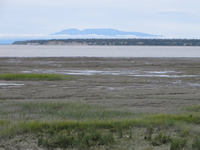 The foreground of this photo shows low, open marshland grading into tidal mudflats, typical of the more coastally-located portions of the Cook Inlet; the body of water, the Knik arm, extends north from the inlet, and the Alaska Range is visible in the distance. Visible in front of the wetlands is a large expanse of boreal forest, typical of uplands in this region. Edit of a photo © Bernt Rostad, CC BY 2.0, Source.