
Home » Regions » North America » Southern Semi-Arid Highlands
Southern Semi-Arid Highlands
Last updated: July 21st, 2020
To check where a specific point lies, you can look it up in our Ecoregion Locator.
↑Map Legend & Subregion List
This list will help you navigate the regions in case you have problems with viewing or clicking the interactive map above.
| Name | † | Color on Map |
| Western Sierra Madre Piedmont | ○ | |
| Mexican High Plateau | ○ |
† Status: ✓ = Complete ○ = Needs Image … = Incomplete ∅ = Stub Only
↑Progress
Partially Complete | With Images | Complete w/ Images |
Get involved! You can help our ecoregion articles progress faster. Help us find photos of these regions. Contact us if you have any additions or corrections to any of these articles. You can also donate to support our ongoing work.
↑About the Southern Semi-Arid Highlands
The Southern Semi-Arid Highlands run northwest to southeast along the Sierra Madre Occidental, and are mostly located within Mexico, with their northernmost tip stretching into southeastern Arizona and the southwesternmost corner of New Mexico.This region is characterized by grasslands and scrublands, with some sparse forests at higher elevations. Grasses are the dominant plant species over much of this region. Species diversity increases as one moves southeast into the warmer regions of Mexico, but this region remains sparsely-vegetated and less biodiverse than nearby higher-rainfall regions that are mostly located southwest of this region, closer to the coast of Mexico. To the east of this region mostly lies desert.
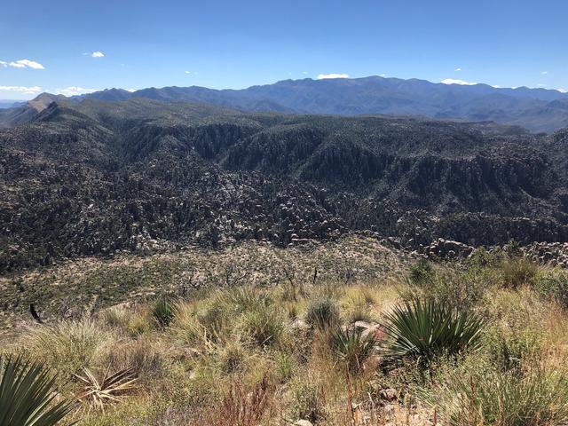 Chiricahua National Monument in the southeast corner of Arizona is one of the few places where the Southern Semi-Arid Highlands intersect the continental U.S.; this ecoregion extends far south into Mexico. Photo © jb10okie, CC BY-ND 2.0
Plant Lists & In-Region Search
List Native Plants - List All Plants
Warning! This region extends outside the lower 48 US. We have only completed range maps for all plants in the lower 48 US; these lists and searches may thus have omissions for species which only occur in the portion of this region outside the lower 48 US.