
Help Us Find Ecoregion Photos
February 27th, 2020 by Alex Zorach
One of the things we have been focusing on over the past few months is adding photos to our ecoregion articles. Of the 165 articles we have completed on Level 4 ecoregions (the finest level of detail on our site) we have added images to 77 of these, which means that a lot of articles still lack images. Some of the higher-level regions also need images.We have been selecting images that illustrate the aspects of topograpy and vegetation cover that make each region unique. We want the photos to visually reinforce what our article describes in words.
Do you have any photos we could use?
We are still missing visuals for a large number of ecoregions, including many where we have completed articles. If you live in or near one of the regions for which we do not have a photo, and you either have taken one yourself (or could take one) that you would like to contribute, or if you know of an open-licensed photo that we could use, please get in touch with us.We have been searching Flickr and Wikimedia Commons for suitable photos, but searching is time-consuming, and any photos you can point us to will save us valuable time that we can commit to working on other aspects of the site. Also, if you know of a large repository of open-licensed images that may help us, please let us know about that too!
What makes a good photo?
The best photos:- show the topography of the land, which often involves being shot from an overlook, observation tower, or the summit of a hill or mountain. Aerial photos taken from a low altitude are often ideal for flatter regions.
- show the typical land use in the region.
- show the typical vegetation cover, ideally with a deep depth of field so as to show both a closeup of some vegetation, and a whole ecosystem in the background.
- illustrate aspects of the region that make it different from its surroundings.
- are aesthetically pleasing and have good composition and lighting.
- either are in the public domain or have an open license that allows reuse, such as CC BY, or CC BY-SA. We avoid licenses with NC (non-commercial) clauses because they can pose problems when combining works with CC BY-SA licenses, as well as unpredictable legal problems in some EU states.
Winter photos can sometimes be excellent for showing the terrain and also drawing attention to evergreens in a landscape of mostly-deciduous plants.
Photo Gallery: Highlights
Here are some of the best photos we have added recently; the captions explain some of why we chose these photos:Midcoast
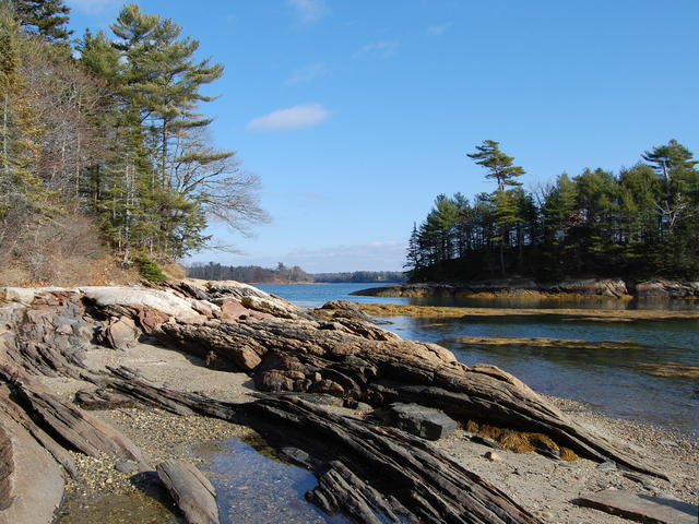 This photo taken near Cushing Briggs, ME, shows a typical Midcoast scenery, with a rocky shoreline with coastal islands and peninsulas. The nutrient-poor areas adjacent to the water are usually dominated by conifers, with white pine dominant here. This is a crop and edit of a photo by Rich Brooks. Photo © Rich Brooks, CC BY 2.0, Source.
Glaciated High Allegheny Plateau
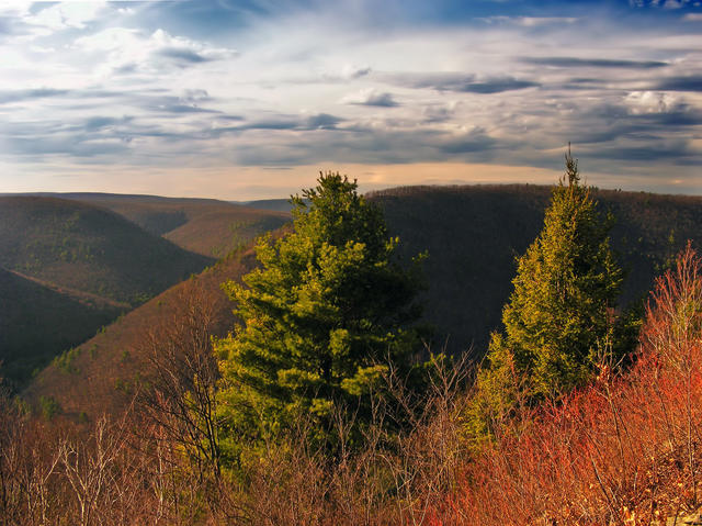 This photo shows the Pine Creek Gorge in Tioga County, from the Mid State Trail at Gillespie Point, which illustrates the typical landscape in this region. The hills are steep but smooth, and the forests are mostly deciduous but with some conifers. Photo © Nicholas A. Tonelli, CC BY 2.0, Source.
Northern Limestone/Dolomite Valleys
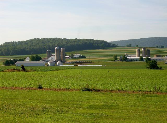 This photo, from Limestone Township, PA, shows a typical scene of farms, reflective of most of this region. The forested ridge in the distance is part of the sandstone ridges that this small, relatively flat valley is nestled between. Photo © Gerry Dincher, CC BY-SA 2.0, Source.
Chesapeake-Pamlico Lowlands and Tidal Marshes
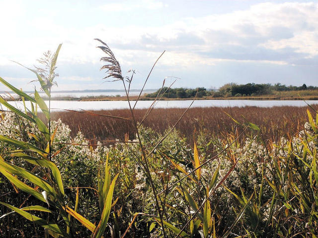 This photo shows a tidal marsh at Eastern Neck National Wildlife Refuge, one of the larger preserves in the Chesapeake-Pamlico Lowlands and Tidal Marshes region. Low-lying marshy areas are dominated by grasses, and woody plants are only found on higher ground, visible here in the distance. Photo © Robert Pos, CC BY 2.0, Source.
Southern Crystalline Ridges and Mountains
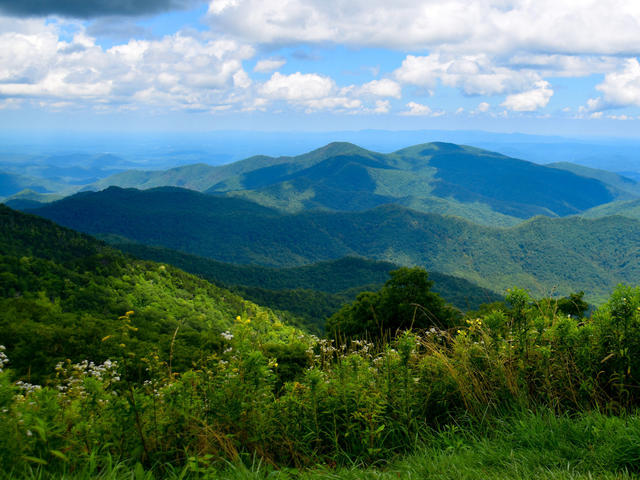 This photo, taken from the Green Knob Overlook on the Blue Ridge Parkway, shows the typical landscape of the Southern Crystalline Ridges and Mountains of the Blue Ridge mountains, with rugged, forested mountains with well-dissected flanks. Photo © Ron Cogswell, CC BY 2.0, Source.
New River Plateau
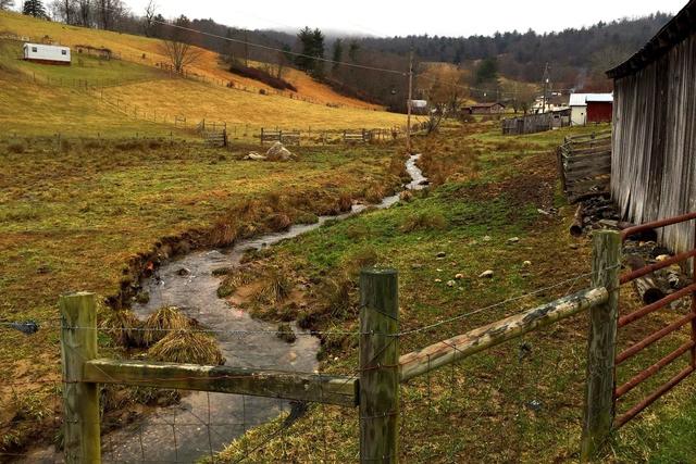 This photo taken in Independence, Virginia, shows a landscape typical of the New River Plateau, with pastureland on the lower, flatter terain, and forest on the steeper uplands. The soil is visibly rocky and shallow and the terrain is irregularly hilly. Photo © Joe Haupt, CC BY-SA 2.0, Source.
Looking for the collage that showed up when this was shared on social media? You can find it here.
Now that you have a good idea of what we are looking for, if you think you may have something to contribute, you can explore our ecoregions via the US state maps, our ecoregion locator, or browsing all of North America, and see if you have or know of any suitable photos for a region where we do not have one yet.
And, even if you aren't able to help in this way, please enjoy what is already there on our site; the main purpose of these articles is educational, so having more people reading the articles and looking at the existing photos is helping us achieve our goals as well!
Archive of All Blogs
How To Identify Plants, May 7th, 2026
The Bias Against Tall Plants, November 11th, 2025
A Focus on Goldenrods (Solidago sp.), July 23rd, 2025
Disturbance and its Role in Plant Habitat Preferences, May 29th, 2025
What "Native" or "Introduced" Mean: Myths and Misconceptions, March 11th, 2025
Smarter & More Informative Search Results, January 13th, 2025
The Effect of the 2024 US Election on Plant Biodiversity and bplant.org, October 30th, 2024
The Problems With Nursery-Bought Plants, And The Solutions, October 8th, 2024
More Databases Linked & Search Improvements for Scientific Names, July 9th, 2024
Choosing The Best Common Names For Plants: Challenges & Solutions, April 19th, 2024
Range Map & Taxonomic Update Progress, January 31st, 2024
Giving Thanks To Everyone We Rely On, November 22nd, 2023
Thinking More Deeply About Habitat, April 5th, 2023
2022 Year-End Summary: Successes & New Goals, February 15th, 2023
New Databases Linked: Flora of North America & NatureServe Explorer, November 11th, 2022
All Range Maps 2nd Generation, Taxonomic Updates, & Fundraising Goal Met!, September 29th, 2022
More Range Map Improvements, POWO Interlinking, And Notes Fields, June 7th, 2022
Ecoregion-Based Plant Lists and Search, March 30th, 2022
Progress Updates on Range Maps and More, February 10th, 2022
The Vision for bplant.org, December 9th, 2021
New Server: Software & Hardware, August 30th, 2021
More & Improved Plant Range Maps, July 19th, 2021
A Control Section for Invasive Plants, April 15th, 2021
Progress Bars & State Ecoregion Legends, March 11th, 2021
Our 2020 Achievements, February 9th, 2021
Interlinking Databases for Plant Research, November 11th, 2020
A New Homepage, Highlighting Our Articles, July 29th, 2020
A False Recovery, But North Carolina's Ecoregions are Complete!, June 9th, 2020
We're Back After COVID-19 Setbacks, April 3rd, 2020
Help Us Find Ecoregion Photos, February 27th, 2020
What We Achieved in 2019, December 30th, 2019
Plant Comparison and ID Guides, October 30th, 2019
We Are Now Accepting Donations, October 14th, 2019
US State Ecoregion Maps, New Footer, Ecoregion Article Progress, and References, September 19th, 2019
Tentative Range Maps of Native Plants, August 12th, 2019
Ecoregion Locator and Interactive Maps, July 10th, 2019
Using Ecoregions Over Political Boundaries, May 13th, 2019
How We Handle Wild vs Cultivated Plants, April 16th, 2019
A Blog To Keep People Updated On Our Progress, April 8th, 2019
Sign Up
Want to get notified of our progress? Sign up for the bplant.org interest list!