Home » Regions » North America » Tundra » Alaska Tundra » Aleutian Islands
Aleutian Islands
Last updated: September 9th, 2024
Page contents
↑About the Aleutian Islands
The Aleutian Islands ecoregion contains all but the easternmost island (Unimak Island) and westernmost islands (Commander Islands, which belong to Russia) considered to be part of the Aleutian Islands, a chain of islands bridging from Asia to North America and marking the south end of the Bering Sea.These islands tend towards the cold end of an oceanic climate. Cloud cover is consistent and fog is frequent; direct sunlight rarely reaches through the dense clouds and fog. Precipitation is high year-round, especially for an area this cold, and is higher in winter. Winter also brings significant snowfall. There is usually little accumulation at sea level as daytime highs usually reach well above freezing even in the coldest months, but significant snow accumulates at higher altitudes. The ocean is free of ice even in winter, and the ground is free from permafrost.
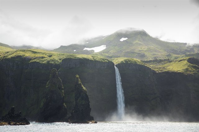
The topography is mostly quite steep, although there are places where it is relatively flatter and consists of rolling hills. The region is formed as a chain of volcanoes at the summit of a ridge formed from the Pacific Coastal tectonic plate subducting under the North American plate. The volcanoes are active, but have also been recently glaciated during colder times, with the glaciers having carved deep valleys and strewn rubble around the edges. There are steep cliffs and fjords along much of the coastline. The region is seismically and volcanically active, with much of the region subject both to earthquakes and volcanic eruptions.
There are numerous short, high-gradient streams throughout, which tend to drain radially around the edges of islands; some flow over steep cliffs into the ocean as waterfalls. There are some small lakes on the flatter terrain, in areas where glacial debris blocked drainage patterns. There are also some lakes filling volcanic calderas and craters.
Soils here are mostly formed either on volcanic ash, or underlying basalt. In broad river valleys and small depressions, there are some soils formed primarily on decaying organic matter.
The vegetation cover here consists mostly of graminoids (grasses, sedges, and the like) and other herbaceous plants on low, sheltered sites, and dwarf scrub communities on slightly higher-elevation sites and areas exposed to wind. Coastlines and mountain flanks support scrubby growth of willow, birch, and alder interspersed with ericaceous and heath shrubs, grasses, Dryas sp., and lichens. Ascending, the cover grades into alpine tundra, becoming barren at the highest elevations. The plant communities are an intergrade of North American flora from the east with Asian flora from the west, with the distribution of specific plants varying considerably throughout the region. Some plant communities have been degraded by the introduction of invasive animals.
Land use here is minimal. This region is sparsely populated; the largest settlement is Unalaska, which houses well over half the population of the entire region. The next-largest town is St. Paul, followed by Adak, then St. George; these are the only settlements with over 100 people. Most of these settlements have been losing population fairly rapidly. The economy here focuses mostly on fishing and hunting, carried out both for subsistence and recreation; most of the fishing is in marine and tidal waters. Some of the land is used by the U.S. Military, and a significant portion of this region belongs to the Alaska Maritime National Wildlife Refuge; this refuge includes Amchitka island, which was used as a nuclear test site, including for the largest-ever underground nuclear test. The area has not been decontaminated, but most of the nuclear contamination remains underground.
The east of this region is bordered, across a distance of water, by Alaska Peninsula Mountains, an ecoregion which includes the easternmost Aleutian Island, Unimak island. That island is included in the Alaska Peninsula Mountains rather than in this region both due to its larger size, and it being separated from the mainland by only a narrow channel, making its flora more characteristic of the mainland and less like the other islands. At the west of this region, the island chain continues into part of Russia which is not considered part of North America more for political reasons, and which is outside the scope of our site, but the Russian islands are more-or-less ecologically similar. These are followed by the Kamchatka peninsula.
 This photo from the Alaska Maritime National Wildlife Refuge shows a coastal landscape typical of the Aleutian islands; a coastline with steep cliffs, volcanic islands with steep topography, and dense cloud cover and fog, covered in lush, green, but low vegetation growth. Photo © U.S. Fish & Wildlife Service, Alaska Region, Public Domain, Source.

