
Home » Regions » North America » Northern Forests » Mixed Wood Shield » Northern Lakes and Forests » Lake Superior Clay Plain
Lake Superior Clay Plain
Last updated: January 3rd, 2021
↑About the Lake Superior Clay Plain
The Lake Superior Clay Plain is a somewhat irregularly-shaped region along the southern shore of the western part of Lake Superior. It consists of two discontinuous pieces, one in northeastern Wisconsin, extending barely into Minnesota, and into the westernmost portion of Michigan's Upper Peninsula, and a second slightly farther east in the Upper Peninsula. The eastern part cuts across the superior mineral ranges, which partly separate it into two portions, one near the lake and one farther inland. The region also include the Apostle Islands in Wisconsin.This region is a flat, clayey lake plain. The soils here tend to be red clays, formed from local, iron-rich, volcanic bedrock and shale. Soil textures range from moderately well-drained to poorly-drained, and tend to be easily eroded. This region is flattest along the lake, and tends to be more sloping farther inland. Contrasting with the mostly-flat terrain, there are steep gorges along rivers and streams, some cut as many as 250 feet into the terrain. There are few lakes or wetlands here. However, soils throughout much of this region are seasonally wet. There are some peaty soils in the Wisconsin portion of this region.
The climate is humid and continental, with high amounts of lake effect snow, as much as 200 inches near the shore. The portion of this region nearest the shoreline has a lake-moderated climate, but this effect is negligible in the more inland portions of this region.
This area was originally covered mostly in mixed hardwood-conifer forest, with eastern white pine (Pinus strobus), eastern hemlock (Tsuga canadensis), northern white-cedar (Thuja occidentalis), black ash (Fraxinus nigra), American basswood (Tilia americana), and sugar maple (Acer saccharum). There was some American beech (Fagus grandifolia) in the east, but it was absent from the west of this region. There were also some more northerly species here, including balsam fir (Abies balsamea), black spruce (Picea mariana), and white spruce (Picea glauca).
The forests here were cleared for logging. Nowadays much of the area is covered in managed second-growth quaking aspen (Populus tremuloides), used for pulpwood. There is a small amount of pastureland here, but much less than in the limestone-based clay plain farther to the east.
This region is bordered to the south by, and in parts, dissected by the Superior Mineral Ranges, a more rugged upland area. The south of the easternmost portion of this region is bordered to the east by the sandier Keweenaw-Baraga Moraines, and to the south by the Winegar Dead Ice Moraine, a region with abundant kettle ponds. In Wisconsin, the St. Croix Pine Barrens, to the south, intrude upon this region, and, in the part extending barely into Minnesota, the westernmost portion of this region is bordered to the southwest by the Minnesota/Wisconsin Upland Till Plain, and in a small border to the north with the Toimi Drumlins.
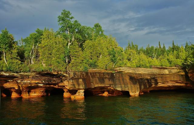 The shoreline of Devil's Island in Wisconsin gives one the unique opportunity to see the fine-textured, iron-rich rocks that weather to form the fine-textured reddish soils of the Lake Superior Clay Plain. Photo © chumlee10 (Flickr), CC BY-SA 2.0, Source.
Plant Lists & In-Region Search
We do not yet have data to generate plant lists for a region as fine-tuned as this one. However you can move up to the broader Northern Lakes and Forests and generate lists for that region: native plants or all plants. Or search that region's plants here:
↑References
1. Omernik, J.M., Bryce, S.A. "Michigan: Level III and IV Ecoregion Descriptions / Mapping Issues", US EPA (2007) Web.
2. Albert, Dennis A. "Regional landscape ecosystems of Michigan, Minnesota, and Wisconsin: a working map and classification.", General Technical Report NC-178, U.S. Department of Agriculture, Forest Service, North Central Forest Experiment Station, St. Paul, MN (1995) Web.