
Home » Regions » North America » Eastern Temperate Forests » Central USA Plains » Central Corn Belt Plains » Sand Area
Sand Area
Last updated: September 8th, 2020
Page contents
↑About the Sand Area
The Sand Area is an irregular part of the Central Corn Belt Plains, consisting of three discontinuous pieces, one in northwestern Indiana and northeastern Illinois (the Kankakee Sand Area), and two farther west in Illinois.This area is covered in extensive volumes of sand left by glaciers. There are sand plains, discontinuous sand dunes, and low-lying marshy spots. Most of the region is covered by well-drained, often excessively well-drained sands, but mucky organic soils have developed in some of the low-lying depressions. The well-drained soils lead water to quickly percolate through to reach the water table, and this area thus has stable stream flow and cool summer water temperatures.
This area was naturally less forested than most of the surroundings, as it lies close to the western border of trees, and the poor ability of the soils to hold moisture hinders tree growth. The driest, sandiest sites supposted dry prairies, and mixed oak savannas or scrub oak forest where trees were able to survive. Black oak (Quercus velutina) is a dominant tree here. Low-lying swampy areas supported swamp forests, open marshes, and wet prairies.
Nowadays, the sandiest sites are still covered in scrub oak forest, but cropland and pastureland occupy most of the rest of the land. Although the dry soils of this region often demand irrigation, groundwater here is plentiful and easily accessible. Cropland here is often irrigated on the drier sites, and drained through use of ditches on poorly-drained sites. There are almost no riparian buffers along the streams and rivers through this region. Although most of the area is sparsely populated, in Illinois it skirts the metro area of two smaller cities, Peoria and Kankakee. The largest city mostly contained in this region is Pekin, IL.
Much of this region borders or is partly surrounded by the Illinois/Indiana Prairies. The eastern section of this area is bordered to the north by the Kankakee Marsh and has a brief border to the northeast with the Battle Creek/Elkhart Outwash Plain. The northwestern section is bordered to the north by the Rock River Hills and the southwestern section has a small border with the River Hills. Both of these western sections are bordered to the west by the Upper Mississippi Alluvial Plain.
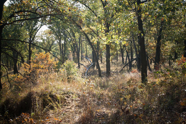 This photo, taken from Kankakee Sands Nature Conservancy, shows a savanna with black oak as the dominant tree; this ecosystem is typical of the natural cover of the sand area. Photo © Justin Meissen, CC BY-SA 2.0, Source.
Plant Lists & In-Region Search
We do not yet have data to generate plant lists for a region as fine-tuned as this one. However you can move up to the broader Central Corn Belt Plains and generate lists for that region: native plants or all plants. Or search that region's plants here:
↑References
1. Woods, A.J, Omernik, J.M., Brockman, C.S., Gerber, T.D., Hosteter, W.D., Azevedo, S.H. "Ecoregions of Indiana and Ohio (Poster)", US Geological Survey (1998) Web.
2. Woods, A.J., Omernik, J.M., Pederson, C.L., Moran, B.C. "Level III and Level IV Ecoregions of Illinois", U.S. Environmental Protection Agency, Washington, DC (2006) Web.