
Home » Regions » North America » Eastern Temperate Forests
Eastern Temperate Forests
Last updated: August 14th, 2020
To check where a specific point lies, you can look it up in our Ecoregion Locator.
↑Map Legend & Subregion List
This list will help you navigate the regions in case you have problems with viewing or clicking the interactive map above.
| Name | † | Color on Map |
| Mixed Wood Plains | ○ | |
| Central USA Plains | ○ | |
| Southeastern USA Plains | ○ | |
| Ozark, Oauchita-Appalachian Forests | ○ | |
| Mississippi Alluvial & Southeast USA Coastal Plains | ○ |
† Status: ✓ = Complete ○ = Needs Image … = Incomplete ∅ = Stub Only
↑Progress
Partially Complete | With Images | Complete w/ Images |
Get involved! You can help our ecoregion articles progress faster. Help us find photos of these regions. Contact us if you have any additions or corrections to any of these articles. You can also donate to support our ongoing work.
↑About the Eastern Temperate Forests
The Eastern Temperate Forests of North America cover most of the eastern United States, and are the most familiar ecoregion to most US residents, as the bulk of the country's population is located within this region.The climate here ranges from humid subtropical in the south and coastal areas, to humid continental in the north, interior, and higher-elevation portions. Most of this region has four well-defined seasons, with hot summers and cold winters. The absence of large mountain ranges in most of the region (the Appalachians are not tall enough to block air masses to the degree that the mountains of the west coast do) allows air masses to move freely, and the chaotic dynamics of weather lead to the possibility of both long or short wet or dry spells, as well as long or short cold or hot spells, at virtually any time of year. Northern regions, particularly in the interior, can have severe winters, but the growing season is long and warm enough to support lush plant growth.
Total precipitation is high enough throughout the whole region to support forest growth on most sites. Most of the region has precipitation roughly equally distributed year-round, although the southwest has a bimodal precipitation pattern with wetter springs and summers and drier fall, the southeast and northwest both have wetter summers and drier winters, the northernmost parts of this region have wetter summers and drier winters, and a few localities have other seasonal patterns in precipitation. Relative humidity tends to be high year-round, especially along the coasts, but there is considerable variation in humidity from day to day, especially in the interior of this region.
The dominant wild ecosystems in this area are closed-canopy deciduous forests, although there are also many coniferous trees in the region as well, and some open wetlands on the wettest sites. Evergreens become more common in regions with more acidic soils, including both sandy soils and colder, high-elevation regions with rocky soils. In the north, and at higher elevations, this region transitions to the Northern Forests, where conifers dominate. In some areas, nutrient-poor, coarse-textured soils such as sand, gravel, rock, or rarely, serpentine minerals in the soil, limit plant growth, leading to various barrens of savanna, or grasslands. In the west of this region, as rainfall declines, savanna and prairie becomes more common, in the region transitional to the Great Plains. In the south of this region, broadleaf evergreen vegetation becomes more common, especially in the coastal areas with mild climates and nutrient-poor soils. Eventually this region transitions into the Tropical Wet Forests, which covers only a small portion of southern Florida.
Overall, plant biodiversity in this region is high; with the exception of two small pockets on the west coast, this region has the highest plant diversity of anywhere in the U.S. and Canada. The diversity is due both to most of this region escaping glaciation, and there being a clear paths along which tropical and subtropical species could expand northward following glacial periods. Within this region, plant diversity tends to be highest in the southeast, especially western Florida, as well as in the southern Appalachians, and the Mid-Atlantic, especially Long Island. There are also pockets of high biodiversity around the southern shore of Lake Michigan, at the confluence of the Ohio and Mississippi rivers, in the Ozark-Oachita mountains, and east Texas into western Louisiana.
Prior to European colonization, this region was inhabited by Native Americans continuously since long before the most recent glacial period; the ecosystems here are thus inseparable from human influence. Throughout much of this region, Native Americans practiced various controlled burning regimes, leading to more frequent, but lower-intensity fires than would occur without human influence, and often were conducted at different timing from natural fires. This activity created a mosaic of grasslands and forest throughout the region, and a higher density of grassland, savanna, and oak-dominated woodlands than would occur naturally.
Much of the forests in this region have been cleared for agriculture and development. Historically, nearly all the forests in this region were cleared after European settlement, but forests have regrown in many places, particularly in the north. Following clearing of land, agriculture was attempted on most land, but it was more quickly abandoned on sites that proved less productive, whereas it has remained on the most fertile land. Only a few isolated regions of old growth forest remain, mostly in more remote, inaccessible areas, such as swamps and areas with steep topography.
Nowadays, some of the most important tree species in this region include the red maple (Acer rubrum), which has increased in frequency due to fire suppression, the American sweetgum (Liquidambar styraciflua), common on moister sites, in the southeast, the loblolly pine (Pinus taeda), which is widely planted in plantations. In the north, sugar maple (Acer saccharum) is a dominant tree. Numerous oaks are also found here, the most important being the white oak (Quercus alba) and northern red oak (Quercus rubra). An important understory tree throughout most of this region is the flowering dogwood (Cornus florida).
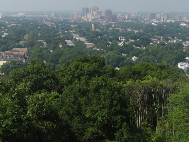 The Eastern Temperate Forests region was naturally mostly covered by lush, broadleaf deciduous forests. It is also the most populous and heavily-developed region. Ths photo illustrates a common sight throughout the region: lush hardwood trees against a backdrop of urban and suburban development. Photo © Alex Zorach, CC BY-SA 4.0
Plant Lists & In-Region Search
List Native Plants - List All Plants
Warning! This region extends outside the lower 48 US. We have only completed range maps for all plants in the lower 48 US; these lists and searches may thus have omissions for species which only occur in the portion of this region outside the lower 48 US.