
Home » Regions » North America » Northern Forests » Atlantic Highlands » Northeastern Highlands » Tug Hill Transition
Tug Hill Transition
Last updated: October 5th, 2020
Page contents
↑About the Tug Hill Transition
The Tug Hill Transition is a donut-shaped region in New York State, surrounding the Tug Hill Plateau, and representing a transition between it and the surrounding lowlands.This region tends to have sloping topography, contrasting with the regions it borders. It is geologically distinct, underlain by siltstone and shale, rocks that are more easily erodible than the sandstone of the plateau, and that tend to form more fertile soils for western agriculture. The central border of this region with the plateau is marked by waterfalls, leading into deep gorges, where streams flow into the more erodible rocks.
The climate here is similar to that of the plateau but slightly less pronounced: it is a humid continental climate with higher than usual precipitation relative to its cool temperatures, typically ranging from 35-38. The high precipitation results from a combination of proximity to Lake Ontario and orographic lift, in which moisture is forced out of air as it rises in elevation and cools. The frost-free growing season averages 100-140 days, only slightly longer than on the plateau itself, and much shorter than the surrounding lowlands.
Original forest cover here was northern hardwoods, with sugar maple (Acer saccharum), American beech (Fagus grandifolia), yellow birch (Betula alleghaniensis), and eastern hemlock (Tsuga canadensis). However, the original cover has been entirely cleared. The remaining landscape is a mosaic of farmland and forest. Current forests are in earlier successional stages and include a mix of sugar maple, black cherry (Prunus serotina), white ash (Fraxinus americana), and red maple (Acer rubrum).
This area is still more actively farmed than the plateau, especially along its outside border, reflecting the greater suitability of soils here for agriculture. Most farming is either dairy production or associated forage crops. This area is slightly more populated than the plateau, but still rural and sparsely populated. Farming is less intense and population lower than in surrounding lowlands.
This region is bordered to the west by the Ontario Lowlands, to the northeast by the Upper St. Lawrence Valley, and to the southeast by the Mohawk Valley, all lowland regions. The border to the west is more gradual and gently-sloping, whereas the eastern border is more abrupt and marked by an escarpment at the edge of the black river valley.
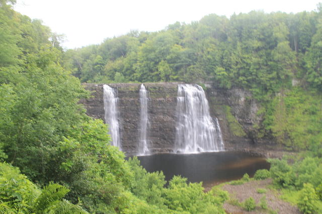 This photo shows steep waterfalls that are typical of the central border of the Tug Hill Transition, where a plateau of less-erodible rocks is surrounded by more easily erodible rocks. Photo © Andy Arthur, CC BY 2.0.
Plant Lists & In-Region Search
We do not yet have data to generate plant lists for a region as fine-tuned as this one. However you can move up to the broader Northeastern Highlands and generate lists for that region: native plants or all plants. Or search that region's plants here:
↑References
1. Bryce, S.A., Griffith, G.E., Omernik, J.M., Edinger, G., Indrick, S., Vargas, O., and Carlson, D. "Ecoregions of New York (Poster)", U.S. Geological Survey (2010) Web.