
Home » Regions » North America » Eastern Temperate Forests » Mixed Wood Plains » Acadian Plains and Hills » Midcoast
Midcoast
Last updated: January 3rd, 2022
Page contents
↑About the Midcoast
The Midcoast is a region located entirely within Maine, along the coast in the middle part of the coastline. This region is characterized by a rugged, rocky coastline, and nowadays is mostly forested although in the past it was heavily utilized for agriculture.This region consists of long peninsulas and numerous small islands, separated by deep, narrow estuaries, mostly oriented in a north-south direction, trending slightly northeast-southwest, reflecting the glaciation that carved out these features. The northeasternmost portion of this region has a high density of small lakes, and there are numerous small ponds throughout the region. The bedrock here is a mix of metamorphic rocks, mixed with some granite. There are bedrock outcroppings throughout, especially along the coast, and there is thin and discontinuous glacial drift, along with silt and clay of marine origin, and glacial till. Soils here have considerable diversity in texture, ranging from excessively-well-drained sands through loams to poorly-drained clays and peaty organic soils. However the soils are more consistently acidic, often rocky and thin, and low in fertility.
The climate is humid and continental with high precipitation relative to what is typical for an area of such low elevation and northerly latitude. Precipitation is roughly equally distributed year-round. The climate is heavily influenced by the ocean, leading to high relative humidity, and milder winters and cooler summers than areas farther inland. Within this region, the moderating effect of the ocean diminishes as one moves inland, and is most pronounced on the coastal islands and peninsulas.
This region is a transitional zone between more southerly and northerly forest types, and has the highest species richness of woody plants in Maine. The dominant forest cover is Red oak-Northern Hardwoods-White Pine forest, featuring northern red oak (Quercus rubra), red maple (Acer rubrum), sugar maple (Acer saccharum), American beech (Fagus grandifolia), eastern white pine (Pinus strobus), eastern hemlock (Tsuga canadensis), and some northern white-cedar (Thuja occidentalis). On richer sites there is beech-birch-maple forest, with sugar maple, beech, and yellow birch (Betula alleghaniensis). Small islands and peninsulas with less-developed, rockier soils have spruce-fir woodlands of red spruce (Picea rubens) and balsam fir (Abies balsamea) on richer sites, and pitch pine (Pinus rigida) woodlands on the harshest, most exposed sites. Farther inland, freshwater tidal marshes feature wild rice, pickerelweed (Pontederia cordata), and bulrush. Bogs and other moist, peaty sites support red maple, black spruce (Picea mariana), and some Atlantic white cedar (Chamaecyparis thyoides), which also reaches its northeasternmost range limit here.
As with much of New England, this region was logged and intensively farmed, in most places to the point of removing nearly all the forest cover, but agriculture has declined in recent years and most of the land has returned to being forested. The little remaining agriculture is mostly hay production and pastureland. The population is much lower here than areas to the southwest; Brunswick is the largest town. There is some commercial fishing along the coast, shipbuilding, especially the Bath Iron Works, as well as some tourism and recreation, quarrying and mining, and cement production.
This region is bordered to the southwest along the coast by the Gulf of Maine Coastal Lowland, a region that is flatter and less rocky, with deeper soils, and to the northeast by the Downeast Coast, another similar region with a rocky coastline but tending to have larger and slightly fewer bays and peninsulas and more contrast between flat and steep areas. Inland, this region is bordered by the Central Maine Embayment, which tends to have more fertile, calcium-rich soils.
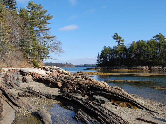 This photo taken near Cushing Briggs, ME, shows a typical Midcoast scenery, with a rocky shoreline with coastal islands and peninsulas. The nutrient-poor areas adjacent to the water are usually dominated by conifers, with white pine dominant here. This is a crop and edit of a photo © Rich Brooks, CC BY 2.0, Source.
Plant Lists & In-Region Search
We do not yet have data to generate plant lists for a region as fine-tuned as this one. However you can move up to the broader Acadian Plains and Hills and generate lists for that region: native plants or all plants. Or search that region's plants here:
↑References
1. Griffith, G.E., Omernik, J.M., Bryce, S.A., Royte, J., Hoar, W.D., Homer, J.W., Keirstead, D., Metzler, K.J., and Hellyer, G. "Ecoregions of New England (Poster)", U.S. Geological Survey (2009) Web.