
Home » Regions » North America » Eastern Temperate Forests » Mississippi Alluvial & Southeast USA Coastal Plains » Atlantic Coastal Pine Barrens » Pine Barrens
Pine Barrens
Last updated: August 4th, 2020
Page contents
↑About the Pine Barrens
The Pine Barrens are a region of New Jersey, making up the bulk of south Jersey. They extend the whole way to the coast along a small stretch, but in most areas they only exist inland.This region is a gently rolling coastal plain with sandy, dry, acidic, infertile soils that support a fire-prone ecosystem. A few sites have poorly-drained sands and thick peat deposits. The climate is humid and subtropical, with rainfall roughly equally distributed throughout the year except for a slight peak in April; although there is abundant rainfall, the soils are very well-drained and poor at holding moisture. The high soil permeability leads rain to sink into the water table almost immediately after falling, with little to no flow over land. Some slow-moving streams can be found where the elevation is low enough to dip below the water table. The peculiar hydrology, with nearly all the water residing in the water table, leads the streams to be cool in summer and warm in winter, rarely freezing.
Upland sites are covered with open pine-oak forests low in plant diversity, tending towards savannah and scrubland on the harshest sites. The fire-tolerant pitch pine (Pinus rigida) is the dominant species, often constituting over half of the trees in these forests; other species present in smaller numbers include shortleaf pine (Pinus echinata), black oak (Quercus velutina), post oak (Quercus stellata), white oak (Quercus alba), scarlet oak (Quercus coccinea), chestnut oak (Quercus montana), and blackjack oak (Quercus marilandica). Areas that burn most frequently and are exposed to the strongest winds have stunted growth of pitch pine, blackjack oak, and occasional post oak. Upland sites protected from the most intense fires support a mix of white, black, scarlet, and chestnut oaks.
Bottomlands, with better access to the water table, support closed-canopy forested swamps, including atlantic white cedar (Chamaecyparis thyoides) swamps on the wettest sites, and on more upland sites still within reach of the water table, a mix of diverse hardwoods with a small amount of pitch pine.
This region includes a few more northerly-distributed plants that reach their southern limits here, and a much larger number of more southerly-distributed plants reaching their northern limits.
Land use includes forestry, with some agriculture and residential development. Although New Jersey has a high population density, this region represents one of the lowest-density parts of the state. Vineland, in the south, is the largest city, although its population density is exceptionally low for a city, under 1,000 people per square mile. The landscape is still mostly forested, and this region makes up nearly half of New Jersey's total forest cover. Agriculture mostly consists of blueberry and cranberry production. These crops are grown in lowland areas, and have resulted in the clearing and alteration of many bottomland sites. The once-abundant Atlantic Cedar swamps have also been greatly reduced by heavy logging. The remaining pine-oak forests are managed both by clearcutting and controlled burning, which helps to maintain them in a relatively steady state; in the absence of fire, some of these woodlands would convert to oak. Significant portions of the region's forests are contained in state parks and the New Jersey Pinelands National Reserve.
This region is bordered coastally to the southeast by the Barrier Islands and Coastal Marshes, to the southwest along the Delaware Bay by the Delaware River Terraces and Uplands, and inland and to the north along the coast by the Inner Coastal Plain. This border is irregularly-shaped and there are some islands of this region within the Inner Coastal Plain.
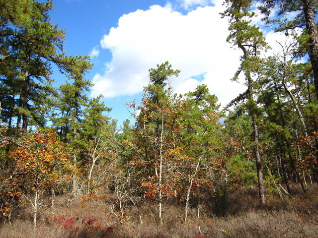 This scene from Wharton State Forest is typical of one of the harsher sites in the pine barrens that burns regularly: pitch pine and blackjack oak dominate, tree growth is stunted, and the forest canopy is open, allowing dense grass growth. Photo © Chris M Morris, CC BY 2.0.
Plant Lists & In-Region Search
We do not yet have data to generate plant lists for a region as fine-tuned as this one. However you can move up to the broader Atlantic Coastal Pine Barrens and generate lists for that region: native plants or all plants. Or search that region's plants here:
↑References
1. Woods, A.J., Omernik, J.M., Moran, B.C. "Level III and IV Ecoregions of New Jersey", (2007) Web.