
Home » Regions » North America » Eastern Temperate Forests » Mississippi Alluvial & Southeast USA Coastal Plains » Middle Atlantic Coastal Plain » Delaware River Terraces and Uplands
Delaware River Terraces and Uplands
Last updated: August 4th, 2020
↑About the Delaware River Terraces and Uplands
The Delaware River Terraces and Uplands is a narrow region along both sides of the Delaware River estuary, extending from southeastern Pennsylvania to Southeastern Delaware and southwestern New Jersey, including the full length of the Delaware bay.This region is marshy and consists of nearly-level terraces. There are abundant tidal wetlands and saltwater marshes, and numerous small, slow-moving streams.
The climate is moderated by the proximity to the ocean, especially towards the southern end of this region.
Before European settlement, this area was dominated by marshes, with Appalachian Oak Forest growing on uplands to the north and Oak-Hickory-Pine Forest on uplands in the south. Marshes were dominated by smooth cordgrass (Spartina alterniflora) in lower areas, and in higher areas, Saltmeadow Cordgrass (Spartina patens). Some higher areas with shallow, highly saline areas that were exposed to salt but would periodically dry out, increasing salt concentrations, would be mostly barren except for glassworts.
This area has been heavily modified by urban development, as it contains the core urban area of Philadelphia, as well as Wilmington, DE. These areas have seen extensive drainage of marshes, dredging, and elimination of tidal wetlands, and also have problems with industrial pollution. The southern portion of this region are more intact, being farther from the urban centers, and including numerous wildlife refuges along both shores of the Delaware bay. Few forests are left, the largest tract of them being in the Wissahickon Valley in Philadelphia. The destruction of wetlands in this area was mostly curbed in 1973 by a series of laws, including "The Wetlands Act" passed by the state of Delaware.
This region is bordered to the west by the Delmarva Uplands in the south and the Piedmont Uplands in the north. On the New Jersey side, it is bordered by the Inner Coastal Plain, and farther south, by Pine Barrens. Where the Delaware bay opens to the ocean, this region borders the Virginian Barrier Islands and Coastal Marshes to the south, and the Barrier Islands / Coastal Marshes to the north. To the north, the Delaware river flows through the Triassic Lowlands before entering this region.
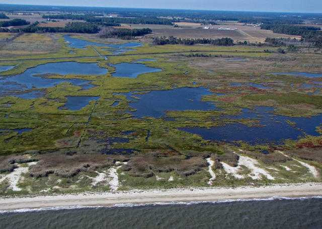 This aerial photo shows the southern end of this region. The view faces west from the Delaware Bay. A small area of beach is followed by extensive salt marsh that shows evidence of past channelization and drainage. Drier uplands in the distance support forests, farming, and some residential development. Public Domain photo courtesy of the U.S. Fish and Wildlife Service, Northeast Region.
Plant Lists & In-Region Search
We do not yet have data to generate plant lists for a region as fine-tuned as this one. However you can move up to the broader Middle Atlantic Coastal Plain and generate lists for that region: native plants or all plants. Or search that region's plants here:
↑References
1. Woods, A.J., Omernik, J.M., Moran, B.C. "Level III and IV Ecoregions of New Jersey", (2007) Web.
2. Woods, A.J, Omernik, J.M., Brown, D.D. "Level III and IV Ecoregions of Delaware, Maryland, Pennsylvania, Virginia, and West Virginia", U.S. Environmental Protection Agency: National Health and Environmental Effects Research Laboratory, Corvallis, OR (1999) Web.