Home » Regions » North America » Taiga » Alaska Boreal Interior » Yukon Flats
Yukon Flats
Last updated: September 24th, 2024
Page contents
↑About the Yukon Flats
The Yukon Flats are a broad bottomland area in east-central Alaska, around where the Porcupine and Chandalar rivers flow into the Yukon river. This region is characterized by flat terrain, with dynamic, heavily-meandering rivers, and a cold, dry climate.The region has a continental, dry-summer subarctic climate. Day-to-day variability is significant, and seasonal temperature variability is particularly high. Relative to areas of similar latitude and elevation, the climate here is unusually dry and has unusually cold winters and warm summers. The water in this region primarily originates in higher-elevation areas to the north, east, and south, with the bulk of the flow coming from the Yukon river flowing from the southeast, as it has the largest watershed. In spite of the majority of water here originating outside this region, temperatures are so low and sunlight so minimal (the weather is overcast more than half the time) such that precipitation here still exceeds evapotranspiration. There is a small amount of snowfall in winter, contributing only a modest amount to total precipitation. Summer conditions are dry enough to make wildfire common.
This region is essentially a flat basin sloping up very slightly around its edges, and sloping downhill slightly with the downstream flow of water to the west. Features here are mostly deposited by water, and are most pronounced around the borders of the region, including alluvial fans where rivers flow into this region, terraces along these rivers, pediments where the original bedrock has been shaped into a gentle concave slope by erosion, and toeslopes at the lowest portions of the bases of mountains. These sloped areas are all better-drained than the central, flatter areas of this region. In most areas, bedrock is covered deeply by material deposited by water, wind, and around the edges of the region, by gravity. Although this region has not been glaciated, it was indirectly shaped by glaciation in that glaciers increased the amount of wind-blown sediments settling here.
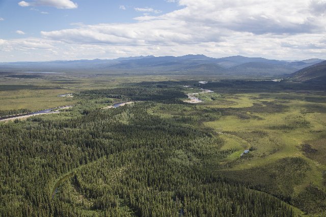
The rivers here are slow-moving, meandering, and larger rivers are braided, forming a maze-like network of constantly-changing channels separating sandbars and small islands. The terrain, including on some of the larger islands, is filled with a high density of oxbow lakes and sloughs that originated as former main channels but became more stagnant as the rivers changed course. Interspersed with these lakes and wetlands originating from the meandering rivers are thaw ponds and lakes formed from the seasonal melting of permafrost. These lakes and wetlands are fed primarily from spring flooding, more so than by rainwater. The relative density of oxbow lakes and sloughs is greatest as one approaches the larger rivers, whereas the wetlands and lakes originate mainly as thaw ponds in the areas farthest from the rivers.
Vegetation cover here ranges from forests, through tall scrub, to open cover of mostly grasslike vegetation, driven mainly by changes in drainage. The best-drained sites on the uplands support closed-canopy forest of spruce, aspen, and birch. Slightly more poorly-drained sites, common throughout, are dominated by open forests of black spruce (Picea mariana). Swampy areas with even less drainage support scrub growth, and the wettest sites are grass-dominated marshes. Although on average the uplands have better drainage, drainage is patchy throughout, with rivers depositing well-drained substrates of sand and gravel in some of the lowest areas, and permafrost leading to pockets of poor drainage even farther from the rivers, so the entirety of the region has considerable diversity of vegetation cover.
This area is mostly unpopulated, with only a few small villages, the largest of which is Fort Yukon, located near the center of this region at the confluence of the Porcupine and Yukon rivers. Land use here is minimal, mostly consisting of subsistence and recreational hunting and fishing. There is a small amount of gold mining.
This region is mostly surrounded, everywhere except to the south, by the Interior Forested Lowlands and Uplands, a region of slightly higher elevation and better drainage; this border is a bit ill-defined and represents a gradual transition. In the south, there is a more abrupt, well-defined border with the Interior Highlands and Klondike Plateau, an area that is considerably higher and more rugged.
 This photograph shows Birch Creek, one of the smaller rivers flowing through the Yukon Flats. The mosaic of closed-canopy forest and open wetlands is typical, and interestingly, the areas farther from the rivers do not necessarily have denser cover, as much of the poor drainage is driven by permafrost, and the rivers can deposit well-drained substrates that facilitate tree growth. Note also oxbow lakes and wetlands filling in the river's former channel in the foreground. Photo © Bureau of Land Management, Alaska, Public Domain, Source.

