
Home » Regions » North America » Northwestern Forested Mountains » Boreal Cordillera » Interior Highlands and Klondike Plateau
Interior Highlands and Klondike Plateau
Last updated: June 18th, 2024
Page contents
↑About the Interior Highlands and Klondike Plateau
The Interior Highlands and Klondike Plateau constitute a region in Alaska and the Yukon. The largest section of this region, the Klondike Plateau, begins just east of Fairbanks and extends southeast into the Yukon. There are also several much smaller discontiguous pieces of this region farther north and west. The northernmost parts reach above the Arctic Circle.The climate is continental and subarctic throughout, with short, warm summers and long, severely cold winters, but there is considerable variation in both quantity and timing of precipitation. The northeast of the Klondike Plateau, near Dawson, as well as the discontiguous northeastern pieces of this region much farther north, both have a dry-summer subarctic climate with abundant winter snowfall but less rainfall in the warm months, whereas much of the region, farther south and west, has a dry-winter climate with much less snowfall but higher summer rainfall. In the northwest of this region, the seasonality of precipitation is pushed back, with a dry late winter and spring, and a wet summer peaking in August, into a wet fall and early winter, with snowfall peaking in November. Total precipitation tends to be highest in the west and lowest in the east. The frost-free period is exceptionally short, varying from 20-70 days. This region has a high rate of lightning strikes, which, combined with dry spells leads to a high rate of wildfires in much of the region.
This region is formed as a dissected plateau, and consists of steep, round-topped ridges and low mountains. Surprisingly for a region this far north, much of the region is unglaciated, but there are some locally-glaciated areas as well. As such much of the region has narrow V-shaped valley bottoms characteristic of unglaciated water-eroded terrain, but these are interspersed with some much larger U-shaped valleys cut by glaciers, which covered most of the higher peaks and extended to lower elevations in a number of areas. There are a few broad flat areas filled with small lakes and wetlands where glaciers have interrupted the drainage pattern, but most of the region has a well-developed drainage network draining into the Tanana and Yukon rivers. There is extensive discontinuous permafrost throughout, governed both by slope aspect and soil texture. Soils here are variable, but tend to be poorly-developed with minimal weathering of minerals, due to the cold temperatures and steep slopes. Soils range from permafrost-dominated turbic cryosols in the coldest areas, to eutric brunisols that formed on loamy colluvium under forests on the warmer sites, and sandy regosols on floodplains.
This region spans the limits of where forests are able to survive. Vegetation varies considerably both by elevation and slope aspect. Warmer south-facing slopes support the richest forest growth, with white spruce (Picea glauca), birch, and aspen. Colder slopes underlain by permafrost feature black spruce (Picea mariana) and paper birch (Betula papyrifera), with black spruce particularly dominant on north-facing slopes. Black spruce also is dominant on bogs in valley bottoms, where it forms more open, stunted growth. Upper elevations and local sites where soil texture or slope aspect does not allow tree growth open up to dwarf scrub with willow and spruce, and graminoids on the more poorly-drained sites. The highest elevations feature low ericaceous shrubs and dryas-lichen tundra, and often considerable areas of barren rock and ice.
This region is sparsely populated; Dawson is the largest settlement, with under 1,600 people, and there are no other settlements with 100 people. Land use here is sparse and includes mining of coal and uranium, and recreation and tourism, hunting, trapping, and fishing. There is a large amount of public protected land here, particularly on the Alaska side of the border, including Yukon-Charley Rivers National Preserve, Steese National Conservation Area, and the Chena River State Recreation Area.
At its southeast end, this region has a large border to the east and south with the Watson Highlands. This border is not necessarily well-defined and represents a gradual transition to a warmer climate. West of that, there is a small border to the southwest with the Wrangell and St. Elias Mountains, a region of high, rugged mountains; that border is marked by an abrupt boundary where the mountains rise out of the much flatter terrain of this region. The northeast of the Klondike Plateau borders the Mackenzie and Selwyn Mountains, another steeper, more mountainous region marked by a clear border, but the border is less pronounced as those mountains are only slightly higher and more rugged, and they adjoin a relatively more rugged portion of this region. Northwest of that, there is another short border to the northeast with the Ogilvie Mountains. Most of this region is irregularly surrounded by the Interior Forested Lowlands and Uplands, a region of interior Alaska that is slightly lower than this one in elevation, but there is a small area towards the north end of the Klondike Plateau where it directly borders the Yukon Flats to the north. The northernmost sections of this region are bordered to the north by the Brooks Range/Richardson Mountains, another area of slightly higher, more ruggged mountains.
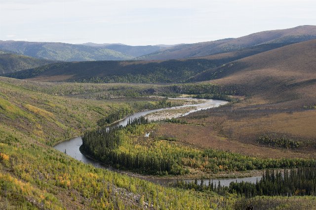 This photo of birch creek in Steese National Conservation Area, Alaska, shows some of the pecularities of the Klondike Plateau, a region that mostly escaped glaciation, unusual for a mountainous region so far north. The valley here has V-shaped walls, steeper at the bottom and not appreciably steeper higher up, reflecting of the sort of terrain cut by water, contrasting with the broad-bottomed, U-shaped valleys formed by glaciers. Note also the patchy forest cover, reflecting discontinuous permafrost that allows forests to grow on some sites whereas others open up to tundra-like vegetation. Photo © Bureau of Land Management Alaska, Public Domain, Source.