Home » Regions » North America » Taiga » Alaska Boreal Interior » Interior Forested Lowlands and Uplands
Interior Forested Lowlands and Uplands
Last updated: September 17th, 2024
Page contents
↑About the Interior Forested Lowlands and Uplands
The Interior Forested Lowlands and Uplands are a large region, mostly located in central Alaska, with a somewhat patchy shape. This region encompasses the mid-elevations of interior Alaska, and stretches roughly from the Bering Strait in the west, north to the Brooks Range, northeast slightly into the northwesternmost part of the Yukon, and south to the foothills of the Alaska Range. The region reaches the farthest south to the west of the Alaska Range.The climate throughout is subarctic and continental, with mild summers, and long, cold winters. Precipitation is strongly seasonal, closely following temperature, although in the west of this region, the precipitation peaks as much as a month after temperature peaks, whereas in the east the temperature and precipitation peaks coincide. The climate also is drier in the east, and both winter lows and summer highs are more extreme, reflecting the presence of the Alaska Range which shelters the more inland portions of the region from both moisture and moderating influence of the Pacific Ocean. In summer, thunderstorms are common and lightning strikes frequently ignite fires.
The terrain here is varied, ranging from nearly entirely level, to rolling hills, with some areas of dissected plateaus. Most of the region is underlain by sedimentary rocks, but there are some areas with volcanic rocks. This area has never been glaciated in Pleistocene (roughly the past 2.6 million years.) In most places the bedrock is buried beneath colluvium (material deposited by landslides) in the steeper areas, and alluvium (material deposited by rivers and streams) in the bottomlands. Permafrost is discontinuous throughout, but averages thicker and more continuous in the west of the region. The region tends to be much better-drained than most areas this far north, and locally poorly-drained areas are smaller and located either along waterways or in areas of permafrost. Contrasting with glaciated regions, there are fewer lakes and ponds, and those present mostly either originated as oxbow lakes or thaw ponds from permafrost.
Vegetation cover is highly varied, including coniferous, deciduous, and mixed forests, including both closed-canopy and open forests (taiga), and tussock tundra. The most dominant trees here are white spruce (Picea glauca) and black spruce (Picea mariana), with tamarack (Larix laricina) common in bottomlands. The dominant deciduous trees are balsam poplar (Populus balsamifera) and quaking aspen (Populus tremuloides), which are mostly found in floodplains. Especially in the northeasternmost portion of this region, open forests of black spruce and tamarack give way to dwarf birch, willow, ericacous shrubs, cottongrass, and lichens and moss. Plant biodiversity here is unusually high due to the long history of this region escaping glaciation; the flora also has a mix of species from different regions, as it is open both at east and west ends, so it features both some more easterly species at their western range limits, and some predominately Asian species at their eastern limits, as well as some species from the interior Northwest reaching their northwesternmost limits here.
Most of this region is sparsely populated. There is significant mining here, of coal, uranium, and other metals, as well as some quarrying of sand and gravel, but only on the Alaska side of the border. Other land uses include subsistence and recreational hunting, trapping, and fishing. There is some recreation and tourism, and tourism has been increasing, particularly in the portion of this region in Canada. The only settlement of appreciable size intersecting this region is Fairbanks, but most of the city is located outside this region, with only the northern portion of it located here. Nearly all the other settlements, even small towns, are located outside this region; an exception is Old Crow in the Yukon, with a population of under 300 people. There is some public, protected land here, the largest of which is where this region crosses through Denali National Park and Preserve.
Because this region spans a large area and has an irregular shape, it borders many different ecoregions. Interspersed throughout this region are the lower, flatter, wetter Interior Bottomlands. Similarly interspersed at higher elevations, but also with a large continuous border in the east, are the Interior Highlands and Klondike Plateau. In the northeast, it mostly surrounds the Yukon Flats. To the south, this region borders the Alaska Range, a range of rugged mountains capped by glaciers and ice fields. To the north, this region is bordered by the Brooks Range Tundra. In the far southwest of this region, there is a border to the southwest with the Bristol Bay-Nushagak Lowlands, and slightly northwest of that, a border to the southwest with the Ahklun and Kilbuck Mountains. The west of this region mostly borders the Subarctic Coastal Plains, except for a small area where it borders the Seward Peninsula.
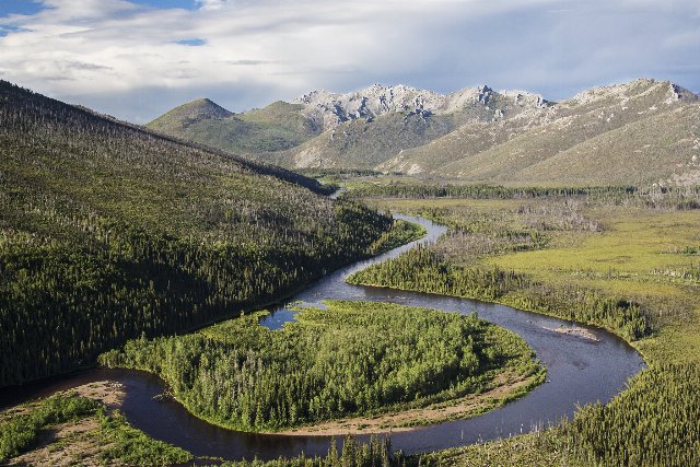
 This landscape in the White Mountains National Recreation Area northwest of Fairbanks shows the full range of terrain and vegetation cover making up the Interior Forested Lowlands and Uplands ecoregion. This region includes flat bottomlands, hills, and low mountains, but the slopes here are relatively gentle and valleys V-shaped and proportional in size to the rivers in them, reflecting terrain formed by water rather than glaciers. Forest cover is irregular, ranging from closed-canopy forests to taiga and open tundra. Photo © Bureau of Land Management, Public Domain, Source.

