
Home » Regions » North America » Northern Forests » Boreal Plain » Mid-Boreal Uplands and Peace-Wabaska Lowlands
Mid-Boreal Uplands and Peace-Wabaska Lowlands
Last updated: April 13th, 2025
Page contents
↑About the Mid-Boreal Uplands and Peace-Wabaska Lowlands
The Mid-Boreal Uplands and Peace-Wabaska Lowlands are an east-west-oriented region stretching roughly from east-Central British Columbia, through central Alberta and Saskatchewan, into Manitoba just north of Winnipeg; the region is largest in Alberta. The region is relatively flat, mostly covered in coniferous forest, and supports forestry and some agriculture. It can be seen as transitional between the more agricultural, formerly open-prairie areas to the south, and less populated taiga regions to the north.The climate here is transitional between the cold end of a humid continental climate and the warm end of a humid subarctic climate. Precipitation is higher in summer only because of higher temperatures; cloud cover and humidity both tend to be higher in the cold moths. The lower elevation leads this area to be significantly warmer than areas of similar latitude to the west, but the central continental location leaves the region exposed to warm or cold spells at all times of year. Day-to-night variation here is thus slightly less than areas to the west, but day-to-day and week-to-week variation in weather tends to be greater. Warm spells here are often caused by chinook winds blowing from the west, which in this region are a type of Foehn wind bringing warm, dry air due to the rain shadow of the mountains. Most of the region is free of permafrost, but there are sporadic to isolated areas of permafrost in the north of the region, densest in the Birch Mountains, uplands northwest from Fort McMurray.
The region is flat over a large spatial scale, but the landscape is shaped by numerous glacial features and can be locally hilly in places. Most areas have gently rolling hills. The uplands are entirely covered in either glacial moraine or deposits that formed under glacial lakes. The drainage network was heavily disrupted by glaciation, and there are a high density of lakes, ponds, and wetlands throughout. There are a number of rivers and streams, mostly occupying oversized channels formed as outwash channels, and they mostly flow northward. Soils tend to be acidic throughout, and soils in depressions tend to be peaty and waterlogged.
Forests here tend to be a mix of mostly conifers with a significant portion of deciduous trees; even in the west, the species are more characteristic of eastern flora than western. Dominant trees include quaking aspen (Populus tremuloides), balsam poplar (Populus balsamifera), white spruce (Picea glauca) and black spruce (Picea mariana). Balsam fir (Abies balsamea) also occurs in late-successional forests here that have been undisturbed for a long time, but is absent from more recently-disturbed sites. Stands of deciduous trees have a rich and diverse understory layer with both shrubs and herbaceous plants, but coniferous stands have a sparser understory dominated by feather mosses (Hypnales order.) Wetlands, including both fens and bogs, tend to support black spruce and tamarack (Larix laricina), with their growth being richer in fens and sparser in bogs.
In the north, the dominant land use here is forestry, producing both pulpwood and sawlogs. There is some oil and gas exploration, as well as water-centered recreation, and hunting, trapping, and fishing. The more southerly portions of this region however, as well as the westernmost end surrounding the Peace River, are heavily utilized for agriculture. This region is more populous than regions to the north and west, but much less so than the region to the south, which has large cities. The largest cities are Fort McMurray, AB and Grande Prairie, AB, followed by Prince Albert, SK, and Cold Lake, AB; there are also numerous towns with populations between 1,000 and 7,000 people, as well as a number of smaller settlements.
At the west end of this region, there are irregular borders to the north, south, and west with the Clear Hills and Western Alberta Uplands, a higher-elevation, hillier, more sparsely-populated region that can be seen as transitional between this and the Canadian Rockies; the border is ill-defined and represents a gradual transition. At the far west of this region, there is a small border directly with the Skeena-Omineca-Central Canadian Rocky Mountains, a much more rugged, higher-elevation region; this border is well-defined and marked by an abrupt change in geology. In the far east of this region, it is bordered to the northeast by the Mid-Boreal Lowland and Interlake Plain. To the south, this region is bordered along its entire length by the Northern Glaciated Plains, which is warmer, more populated, more intensely utilized for agriculture, and which would have naturally supported more open prairie vegetation.
In the northwest of this region, it is bordered to the north by the Hay and Slave River Lowlands, another low, flat region but that is colder, more sparsely-populated, and features discontinuous permafrost and thus more open taiga rather than closed-canopy boreal forest. East of that, this region is bordered to the north by the Athabasca Plain and Churchill River Uplands, a region that is still mostly covered in closed-canopy boreal forest.
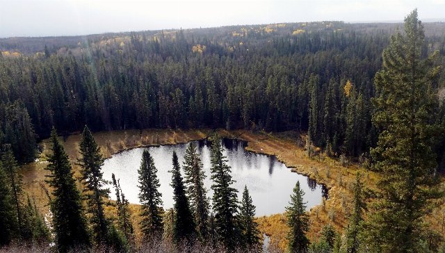 This photo of Narrow Hills Provincial Park in Saskatchewan shows a typical landscape of a relatively intact wild area in the Mid-Boreal Uplands and Peace-Wabaska Lowlands. A pond is surrounded by a boggy wetland, whereas drier ground supports dense coniferous forest. The terrain is relatively flat but there are rolling hills in the distance. Lighting altered from photo © Rob Swystun, CC BY 2.0, Source.