
Home » Regions » North America » Northwestern Forested Mountains » Western Cordillera » Skeena-Omineca-Central Canadian Rocky Mountains
Skeena-Omineca-Central Canadian Rocky Mountains
Last updated: October 11th, 2023
Page contents
↑About the Skeena-Omineca-Central Canadian Rocky Mountains
The Skeena-Omineca-Central Canadian Rocky Mountains are a section of mountains and plateaus in central British Columbia that make up the northernmost regions of the Western Cordillera, just south of the transition to what our classification scheme treats as the Boreal Cordillera. This region includes the Skeena Mountains to the west, the Omineca Mountains east of that, and in the east of this region, the Hart Ranges of the Central Canadian Rockies, a section that is relatively lower in elevation than the portions of the Rockies farther north and south. In between these ranges, particularly in the southernmost part of this region, are some relatively flatter plateaus with terrain that is minimally dissected but heavily marked by glacial features.The climate here is mostly subarctic, ranging into the cold end of a humid continental climate at the lower elevations in the south of this region, and into a tundra climate at the highest elevations. There are isolated pockets of permafrost particularly at higher elevations in the northwest. Precipitation is seasonal, with a rainy season peaking in summer but precipitation staying high through January, followed by a dry season from February through April. This pattern is relatively consistent throughout this region. The climate throughout most of the region has significant influence from the Pacific ocean, making the weather a bit more predictable day-to-day than areas farther east. In the easternmost portions of the region, closer to the Great Plains and farther from the Pacific there is more continental influence, and the period from fall into early winter becomes relatively drier.
Although this region is relatively cohesive with respect to elevation and climate, it is a bit of a hodgepodge geologically. The Omineca mountains have a mix of sedimentary and crystalline igneous rocks, arranged in long bands. The Skeena Mountains are more folded, and consist of a mix of sedimentary and volcanic rocks. The Hart Ranges here consist of layers of quartz and limestone much like the portion of the rockies north and south of here, but there is a greater portion of schist, which is more easily erodible than quartzite, and has resulted in lower elevations and more rounded tops to the highest peaks. Throughout the region, peaks tend to reach to between 2,400-2,700m (7,874-8,858ft).
The vegetation cover here tends to be highly stratified by elevation. Lower elevation consists mostly of sub-boreal forests, with dominant species being quaking aspen (Populus tremuloides), balsam poplar (Populus balsamifera), paper birch (Betula papyrifera), lodgepole pine (Pinus contorta), black spruce (Picea mariana), and white spruce (Picea glauca). Higher elevations support subalpine forests of engelmann spruce (Picea engelmannii), white spruce, and subalpine fir. Above the tree line there are alpine meadows with low-growing heather, heath, sedges, and mountain-avens (Dryas sp.)
This region has a high density of lakes owing to its history of glaciation, leading to a disrupted drainage network, combined with the climate having a high ratio of rainfall to evaporation due to the cold tempeartures. The density of streams and rivers is low, and they mostly flow southeast. The hydrology in the north of this region, and extending well beyond it, has been greatly altered by the creation of Williston Lake, formed by the W.A.C. Bennett Dam. This reservoir is one of the largest in the world, filling most of the basin of the Peace River and the beginning of the Rocky Mountain Trench, and draining to the northeast and eventually into the Arctic.
Land use here is fairly diverse but less intensive than regions farther south. There is significant forestry, mostly in the mountains. There is also some mineral exploration and mining, as well as hunting, recreation, and tourism throughout. This region is relatively more populated than any of the bordering regions, with settlements concentrated along the major east-west corridor of highway 16 or the north-south corridor of highway 97. The largest city, located at the intersection of these two roads, is Prince George, with a population over 76,000. The city of Quesnel, which has a fairly populous metro area, is located in the south of this region. Other sizeable towns include Smithers (at the northwestern border of this region), Vanderhoof, Mackenzie, Houston, Burns Lake.
In the south, this region is bordered to the southwest by the warmer Chilcotin Ranges and Fraser Plateau, a region made up entirely of plateaus and lacking the higher elevations found in this region; that region also has deeper-cut gorges along the major rivers, and fewer and smaller lakes than here. This border is subjective and represents a gradual transition. The border to the southeast is with the Northern Rockies in the central part of the region, and with the Canadian Rockies in the east. Both of these regions are higher-elevation and more rugged; the Northern Rockies have greater influence from the Pacific and thus a wetter and more moderate climate, whereas the Canadian Rockies have a slightly drier and more extreme climate.
The border to the northeast is with the Clear Hills and Western Alberta Uplands, except in one spot where there is a border to the east with the Mid-Boreal Uplands and Peace-Wabaska Lowlands; these regions mark the beginning of the Boreal Plain, a flatter region that is like a forested extension of the Great Plains. To the north, there is a border with the Yukon-Stikine Highlands/Boreal Mountains and Plateaus, marking the beginning of the Boreal Cordillera, a rugged, high-elevation region that is much colder than here. To the west and southwest, this region borders Pacific and Nass Ranges, also a taller and more rugged region, but with heavy influence from the Pacific ocean and thus a more moderate and wetter climate.
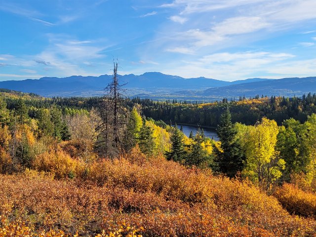 This September photo shows lower elevations in the Skeena-Omineca-Central Canadian Rocky Mountains; this region's drainage network has been disrupted by glaciation, with numerous lakes of varying sizes. The landscape is mostly forested, with lower elevations having a mix of evergreen conifers and deciduous trees, visible here as they change color in autumn, a season that arrives quite early this far north. Crop of a Photo by Lauren Bosch, Public Domain.