
Home » Regions » North America » Northern Forests » Boreal Plain » Clear Hills and Western Alberta Uplands
Clear Hills and Western Alberta Uplands
Last updated: April 10th, 2025
Page contents
↑About the Clear Hills and Western Alberta Uplands
The Clear Hills and Western Alberta Uplands are a set of two discontiguous sections on the eastern border of the Canadian Rockies, each lying in west-central Alberta and east-central British Columbia. The region can be seen as transitional between the mountains to the west and the flatter regions to the east.The climate here is transitional between the cold end of a warm-summer humid continental climate and the warm end of a humid subarctic climate. Precipitation is higher in summer, but only because of higher temperatures; relative humidity and cloud cover are both higher in winter. Some snowfall occurs for about 7 months out of the year. Moving west and to higher elevations, precipitation increases and average temperatures decrease, but temperature swings also become more extreme. Lower elevations in the east, however, receive more of their precipitation as snowfall. Most of the region is devoid of permafrost, but the northernmost regions begin to have some sparse, discontinuous permafrost.
The terrain consists mostly of rolling uplands, with some narrow canyons along rivers and streams. Recently glaciation has left an irregular landscape with a poorly-developed drainage network. The most common soils are formed on glacial moraine, with some low-lying areas having lacustrine deposits and/or organic soils formed on peat. Organic soils become more dominant in the north, making up about half the surface soils there. The land gradually slopes east, the northern portions draining into the Peace and Athabasca rivers, which eventually drains northward, and the southernmost reaches draining into the Saskatchewan river, which flows eastward. Several rivers originating in the Canadian rockies flow into this region. Parts of this region have poor drainage and an abundance of lakes of varying sizes, whereas other parts are better-drained.
Coniferous forests cover most of the area, but there are some deciduous trees as well; the vegetation here is transitional between the boreal forests east of here, and the species more typical of the Canadian rockies. Dominant trees include lodgepole pine (Pinus contorta), quaking aspen (Populus tremuloides), white spruce (Picea glauca), balsam poplar (Populus balsamifera), paper birch (Betula papyrifera), and balsam fir (Abies balsamea). Lodgepole pine and quaking aspen are dominant on drier sites, whereas poorly-drained, wet sites support black spruce (Picea mariana) and tamarack (Larix laricina). Cooler, higher elevations have mostly conifers, whereas hardwoods, especially aspen, are more common at lower elevations.
The economy here centers around forestry, producing both pulpwood and sawlogs for lumber. There is some oil and gas exploration, recreation (mostly centering around water), and hunting and trapping. There is a small amount of agriculture near the east border of this region, mostly production of forage and some grain. Although most of this region is minimally developed, the development is denser along major roads. Several highways cut through this region in various places, but elsewhere there are only small logging roads. The population is sparse and mostly concentrated along major highways. The largest two towns are Hinton and Edson, both in Alberta. Bighorn Dam is located here, damming the North Saskatchewan river; this dam was constructed without any regard to environmental or social issues, and it is used both for generating electricity and the creation of Abraham Lake, the largest reservoir in Alberta, reaching upstream beyond this region and into the Canadian Rockies.
The Mid-Boreal Uplands and Peace-Wabaska Lowlands both borders this region to the east, and separates its two sections, with ill-defined borders representing a gradual transition; this other region is lower, flatter, and more populous. To the southwest, the southern portions of this region are bordered by the Canadian Rockies, a clear border marked by a change in geology, where the terrain becomes much steeper and rises abruptly to higher elevations. In the north, the southwestern border is instead with the Skeena-Omineca-Central Canadian Rocky Mountains, a more northerly section of the same mountains. In the north of this region, it is surrounded to the north by the Hay and Slave River Lowlands, another low, flat region but one that is colder, sparsely populated, and features open Taiga with more permafrost.
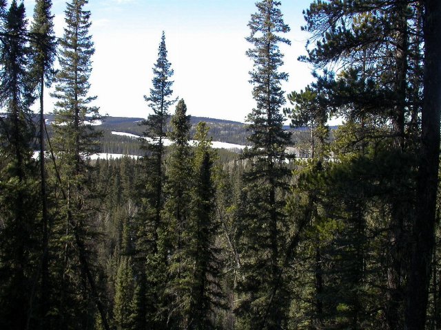 This photo shows Wildhay Glacial Cascades Natural Area, north from Hinton, AB. The terrain and cover here is typical for one of the intact wild areas in the southern portion of the Clear Hills and Western Alberta Uplands ecoregion. Photo © Alberta Parks, Copyright, All Rights Reserved, Source.