
Home » Regions » North America » Northwestern Forested Mountains » Western Cordillera » Cypress Uplands
Cypress Uplands
Last updated: October 3rd, 2023
Page contents
↑About the Cypress Uplands
The Cypress Uplands are an isolated region of higher-elevation hills rising out of the flat landscape of southeastern Alberta and southwestern Saskatchewan.This region's climate is borderline between the warmer end of a subarctic climate and the colder, drier end of a humid continental climate. The climate is both colder and wetter than that of the surroundings; although the difference is relatively subtle, because the precipitation levels here are near the transition point between grassland and coniferous forest, small changes in elevation drive major changes in vegetation cover. Rainfall gradually increases with elevation, mostly varying from about 325-450mm (13-18in).
The vegetation here represents an island of montane open forests typical of the lower slopes of mountainous regions farther west, surrounded by a broad landscape of prairie grasses. Lodgepole pine (Pinus contorta), white spruce (Picea glauca), and quaking aspen (Populus tremuloides) are dominant, and various other deciduous trees and shrubs are also found here. The name "Cypress" likely stems from French Canadian explorers who used the word "cyprès" innacurately to refer to pine forests. A number of plants absent from the surrounding praries occur here, including larkspur, meadow deathcamas (Toxicoscordion venenosum), and lupine (Lupinus sp.) Lower elevations transition into the surrounding prairie with dominant vegetation of mountain rough fescue (Festuca campestris) and wheatgrass. This grass cover is more typical of the foothills of mountains farther west. Warmer, south-facing slopes at lower elevations feature plains rough fescue (Festuca hallii), which is dominant in surrounding prairie regions.
Prior to European colonization, nomadic Native Americans spent the winter here, benefitting from the increased shelter of the terrain and abundance of game, which was also attracted here by the greater shelter and food. In 1873, some European Americans massacred some of the Assiniboine people here. Fort Walsh was built here, and was the site of attempts to mediate with Sioux refugees fleeing violence across the US border; the fort was abandoned shortly thereafter when the Sioux returned to the US, and is now a national historic site.
Presently, the lower elevations in this region are more intensively utilized, with free-range livestock grazing being the dominant land use; there are small amounts of cropland that produce cereal grains. The higher-elevation, forested areas are utilized for recreation and hunting. There are some towns around the lower-elevation borders of this region, the largest of which is Eastend, SK, located along the Frenchman river. The only town in the more central, forested area is Elkwater, AB which has under 100 people. The Nekaneet Reserve of the Nekaneet Cree Nation is also located here. There are some towns on the outskirts of this region, in open areas where grasslands are more dominant.
This is one of the better-preserved ecoregions anywhere in North America, with as much as 75% of the unique habitats here mostly intact. However, this region has been threatened by an increase in agriculture, oil and gas explonation, and residential development in the region. Although all such land uses are still rare, all have been on the increase.
This region is entirely surrounded by the West-Central Semi-Arid Prairies, a lower-elevation, flatter, more arid region dominated by grassland. The border is not necessarily well-defined as the terrain slopes up gradually into this region.
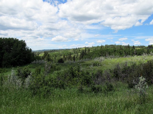 This photo shows the patchy, irregularly hilly landscape typical of the border of the Cypress Uplands, in which prairies transition to open coniferous forests. Photo © daryl_mitchell (Flickr), CC BY-SA 2.0, Source.