
Home » Regions » North America » Northwestern Forested Mountains » Western Cordillera
Western Cordillera
Last updated: October 13th, 2023
To check where a specific point lies, you can look it up in our Ecoregion Locator.
↑Map Legend & Subregion List
This list will help you navigate the regions in case you have problems with viewing or clicking the interactive map above.
| Name | † | Color on Map | CEC Code‡ |
| Cascades | ✓ | 6.2.7 | |
| Blue Mountains | ✓ | 6.2.9 | |
| Northern Rockies | ✓ | 6.2.3 | |
| Idaho Batholith | ✓ | 6.2.15 | |
| Middle Rockies | ✓ | 6.2.10 | |
| Wasatch and Uinta Mountains | ✓ | 6.2.13 | |
| Southern Rockies | ✓ | 6.2.14 | |
| Canadian Rockies | ✓ | 6.2.4 | |
| Sierra Nevada | ✓ | 6.2.12 | |
| North Cascades | ✓ | 6.2.5 | |
| Klamath Mountains/California High North Coast Range | ✓ | 6.2.11 | |
| Eastern Cascades Slopes and Foothills | ✓ | 6.2.8 | |
| Skeena-Omineca-Central Canadian Rocky Mountains | ✓ | 6.2.1 | |
| Chilcotin Ranges and Fraser Plateau | ✓ | 6.2.2 | |
| Cypress Uplands | ✓ | 6.2.6 |
† Status: ✓ = Complete ○ = Needs Image … = Incomplete ∅ = Stub Only
‡ This code refers to the CEC's Level 3 ecoregion codes for North America, see here.
↑Progress
Partially Complete | With Images | Complete w/ Images |
Get involved! You can help our ecoregion articles progress faster. Contact us if you have any additions or corrections to any of these articles. You can also donate to support our ongoing work.
↑About the Western Cordillera
The Western Cordillera is a mountainous region in Western North America covering most of the Rocky Mountains. The region extends from British Columbia and southwestern Alberta, through several discontinuous pieces in most states of the western U.S., with the southernmost parts of this region extending into California and northern New Mexico.Topography here tends to be steep, reaching heights over 14,440 feet (4400m) in Colorado, with elevations over 10,000 feet (3000m) occurring across the region. The entire north of this region, into northern Washington and Montana, was glaciated, and the rest of this region had isolated glaciers at the highest elevation. Thus in the north, side-slopes and mid-elevation plateaus have a disrupted drainage network with numerous lakes throughout, huge outwash channels, and numerous glacial features, and the south has some such features at higher elevations. But in the south, lower-to-mid levations feature a water-dissected landscape.
The climate varies considerably, both with changing altitude, and changes in microclimate on different-facing slopes. Precipitation is mostly generated from orographic lift, as moisture-laden air masses from the Pacific move west-to-east, cooling as they ascend mountains. Snowfall followed by melting supplies much of the moisture for streams and rivers which flow out of this region into other, more arid areas of low elevation. Precipitation is seasonal throughout most of the region, but the patterns of seasonality vary regionally, owing to different sources of seasonality: the west of the region is affected by the north-south movement of the high pressure zone off the West Coast, and follows a similar pattern to West Coast weather, with wetter winters and drier summers. The south is more affected by the North American monsoon, bringing some moisture in summer, which balances to have more constant year-round precipitation. The north is affected more by the lower moisture content of cold air masses in winter, and the east more by irregular movements of air masses on the Great Plains.
The classification of the climate ranges from arctic and subarctic at the highest elevations, through alpine climates, to humid continental climates at mid elevations and semi-arid continental climates the lowest elevations. As one ascends in elevation, temperatures become cooler, but temperature swings more extreme, and precipitation increases. The westernmost portions of this region, with more Pacific influence, have higher rainfall at similar elevations, more moderate temperatures, and more predictable weather day-to-day. The eastern portions, on the other hand, average drier and also have more continental influence, not only with more extreme weather across the board, but more week-to-week variability, including some prolonged hot, cold, wet, or dry spells resulting from the motion of different air masses across open parts of the continent.
Vegetation cover here ranges from minimal to lush. Barren and snow-capped mountains with numerous rock outcroppings are found the highest elevations, through coniferous forest to mixed forest at lower elevations, opening again to grass or scrubland at the lowest elevations. Although the species diversity in many of these specific habitats is lower, the region as a whole is high in biodiversity owing to the great diversity of climate and cover type. The island-like nature of many of these regions, particularly in the south, surrounded by dissimilar ecosystems, leads to a lot of endemic species, although fewer than in the Temperate Sierras farther south. At the same time, many cold-tolerant species are found here that also occur across a wide range of boreal forest in the Northern Forests and Taiga regions. The richest forest growth occurs at mid elevations, high enough to provide sufficient rainfall, but not so high that cold temperatures and poorly-developed soil stunt plant growth.
Most of this region is surrounded by more arid areas at lower elevations, mostly the Cold Deserts of the interior west. To the east, at lower elevations, lies the Great Plains, more specifically the West-Central Semi-Arid Prairies in the northern U.S. and the South Central Semi-Arid Prairies in the south. However, in Canada, the east of this region is bordered by the still-forested Boreal Plain, and this border shares many plant species in common as both regions have sufficient moisture to support forests. The southernmost border of this region on the West Coast borders the wetter and milder Marine West Coast Forest, and farther south, the drier but milder Mediterranean California. The border with the Marine West Coast Forest is more gradual (except where separated by very high mountains in Canada) and there are more plant species shared in common between these areas as well.
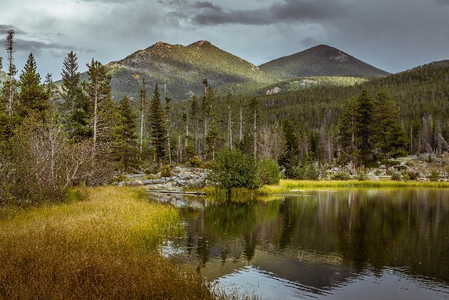 This lake at over 8,800ft in elevation shows a landscape typical of the southern parts of the Western Cordillera, with coniferous forest that opens into sparser cover with exposed rock outcroppings at higher elevations. Lakes like this are widespread in the glaciated parts of this region. Photo © Christian Collins, CC BY-SA 2.0, Source.
Plant Lists & In-Region Search
List Native Plants - List All Plants
Warning! This region extends outside the lower 48 US. We have only completed range maps for all plants in the lower 48 US; these lists and searches may thus have omissions for species which only occur in the portion of this region outside the lower 48 US.