
Home » Regions » North America » Northwestern Forested Mountains
Northwestern Forested Mountains
Last updated: July 21st, 2020
To check where a specific point lies, you can look it up in our Ecoregion Locator.
↑Map Legend & Subregion List
This list will help you navigate the regions in case you have problems with viewing or clicking the interactive map above.
| Name | † | Color on Map |
| Boreal Cordillera | ✓ | |
| Western Cordillera | ✓ |
† Status: ✓ = Complete ○ = Needs Image … = Incomplete ∅ = Stub Only
↑Progress
Partially Complete | With Images | Complete w/ Images |
Get involved! You can help our ecoregion articles progress faster. Contact us if you have any additions or corrections to any of these articles. You can also donate to support our ongoing work.
↑About the Northwestern Forested Mountains
The Northwestern Forested Mountains region extends over a large distance from central North America, northwest into Alaska, with the bulk of the region in the pacific northwest, slightly inland from the coast.The region is characterized by precipitation generated by orographic lift, leading to high local variation in rainfall and moisture availability. The region becomes moister and more moderate towards the northwest. Inland areas farther south are drier but have more moderate temperatures due to their more southerly location. This pattern leads winter low temperatures to vary less over long distances than one might expect based on latitude alone.
Snowmelt also plays a key role in moisture availability throughout this region, as high elevations receive both more total precipitation and a greater portion of their precipitation as snowfall; snowmelt releases water in spring, supplying it to lower-elevation regions.
In the Pacific Northwest, towards the ocean this region transitions to the Marine West Coast Forest, which has more moderate and more consistently wet temperatures. In the inland West, as one moves to lower altitudes, this region transitions to Desert, and further east, to the slightly less arid Great Plains. This region is mostly separated geographically from the Temperate Sierras, a warmer and more southerly mountainous region. What little transitional zone exists between these regions consists of isolated mountains separated by significant stretches of desert.
In this region, winter temperatures are quite cold due to altitude, even towards the south of this region. Soil tends to be poor due both to the steep topography and cool temperatures that slow decomposition of organic matter. This region shares much in common with the Northern (Boreal) Forests that occur across much of Canada, even in flatter regions and at lower altitudes. Many plant species are found in both regions, having ranges that stretch in an L-shape eastward along the boreal forest and south along the rocky mountains.
Owing to the steep topography, most of this region is sparsely populated by humans, with a total population of about 800,000 spread over more than 680,000 square miles, leading to a population density of barely more than 1 person per square mile over the region as a whole; larger settlements tend to be at lower altitudes and in flatter areas. In spite of the low permanent population, this region is a popular tourist destination for hiking, skiing, and other forms of outdoor recreation. It is also heavily utilized for forestry and mining.
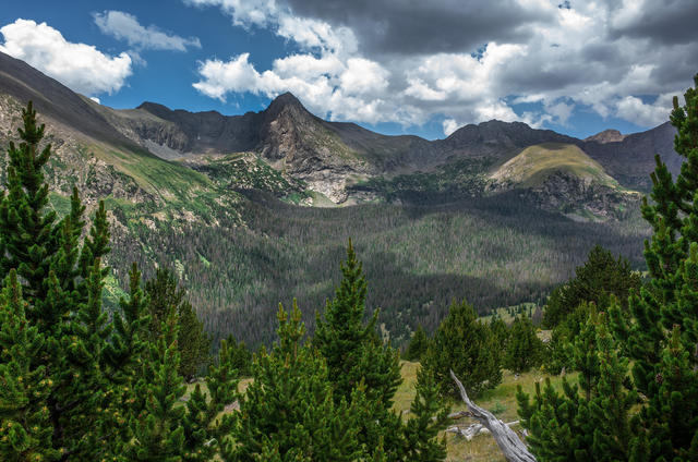 This photo from Custer County, CO, shows how sharply the vegetation in mountainous regions can change with altitude. Photo © Adam Meek, CC BY 2.0
Plant Lists & In-Region Search
List Native Plants - List All Plants
Warning! This region extends outside the lower 48 US. We have only completed range maps for all plants in the lower 48 US; these lists and searches may thus have omissions for species which only occur in the portion of this region outside the lower 48 US.