
Home » Regions » North America » Great Plains » South Central Semi-Arid Prairies » Cross Timbers » Northern Cross Timbers
Northern Cross Timbers
Last updated: January 30th, 2025
Page contents
↑About the Northern Cross Timbers
The Northern Cross Timbers are the northernmost portion of the Cross Timbers, located at the east-central portion of the South Central Semi-Arid Prairies, mostly in Oklahoma and extending slightly into Kansas. Owing to the topography and limestone substrates, this region has richer tree growth and more forest cover than much of the Great Plains. It is also a region of great diversity of vegetation cover and soil types.The terrain here is varied, with rolling hills, cuestas (ridges with a steep slope on one side and gentle slope on the other), and ledges. This region is underlain by sandstone, shale, and limestone, which in many places are covered in decomposition residuum formed by thorough weathering of the underlying rocks. This residuum varies in both texture and mineral content, from silty clay, clayey silt, through clay-loam, to sandy loam and sand. Soil pH is highly variable, but in general, acidic soils are more common than areas to the north, west, and south, whereas alkaline soils are also more common than areas to the east. Rock outcroppings are common throughout, typically driven by the distribution of resistant sandstone, which sometimes protects outcroppings of other rocks underneath. Sandstone blocks and boulders are common on ridges, hilltops, and slopes. The diversity of parent rocks, topography, and degree of weathering of the material, combined with the diversity of vegetation cover, leads this region to have great diversity in surface soils. Many of the soils are prone to erosion if vegetation is disturbed.
There are numerous streams throughout, but many are seasonal or intermittent. Stream flow varies irregularly both from season-to-season, and year-to-year. Most streams flow over sandy bottoms, but there are areas where they flow over bedrock, or gravel or larger rocks, and in places they can form deep pools. Smaller pools can be ephemeral, but, especially where constrained by larger, impermeable sandstone blocks, isolated perennial pools can form.
The vegetation cover here is extraordinarily diverse and historically, spanned the full range from closed-canopy forests to treeless tallgrass prairie, with the most widespread cover being savanna or open forests. Overall, the most common species throughout are post oak (Quercus stellata), blackjack oak (Quercus marilandica), and little bluestem (Schizachyrium scoparium), which is typical of the broader Cross Timbers region. Tallgrass prairie was dominant on drier sites with clayey soils derived from limestone or shale, and supported dominant vegetation of big bluestem (Andropogon gerardii), little bluestem, switchgrass (Panicum virgatum), and yellow indiangrass (Sorghastrum nutans), along with many other herbaceous plants. In areas with thin or shallow soil, there were small areas of shortgrass prairie. Bottomlands underlain by shale supported savanna with scattered, stunted trees. Sloping uplands with coarse-textured soils supported oak-hickory forest with post oak, blackjack oak, black hickory (Carya texana), black oak (Quercus velutina), common persimmon (Diospyros virginiana), eastern redbud (Cercis canadensis), smooth sumac (Rhus glabra), and winged sumac (Rhus copallinum).
Nowadays, the vegetation cover has changed considerably, and overall, forest cover has increased and prairie decreased. Much of the region is now covered by scrubby oak forests, and oak savannas. There are some prairies remaining; riparian forests remain more similar to their original state. Owing to fire suppression and suppression, eastern redcedar (Juniperus virginiana) has become common, especially in upland oak-hickory forests.
Land use here is diverse but not particularly intense. The land is a mosaic of woodland, wild grasslands, rangeland, and pastureland, with small amounts of cropland. Farmland here is declining and there are large areas of recently-abandoned farmland. There are extensive oil fields here, but oil drilling is also on the decline. Waste from oil drilling, including brine and mud, have led to increased salinity in many streams. There are a number of reservoirs of varying sizes constructed by damming, the largest of which is Keystone Lake on the Arkansas River, followed by Skiatook Lake, and the smaller Birch, Hulah, and Heyburn lakes. These reservoirs flooded and destroyed bottomland habitats as well as lower slopes.
Most of this region is sparsely populated. The far north of this region contains the westernmost limits of the Tulsa metropolitan area, including the communities of Sand Springs, Oakhurst, Prattville, Sapulpa, and Hilton. Outside of this area, the next largest city here is Ada, followed by the smaller city of Seminole, and the even smaller town of Pawhuska, all in Oklahoma. The Seminole Nation is located entirely within this region; the Seminole people arose in the 1700's in Florida as Native Americans from various groups, as well as fleeing slaves, combined to form a new cohesive culture. The Seminole lived in Florida for some time but were forcibly relocated to this area.
The narrow, northern portion of this region is bordered to the east by the Osage Cuestas and the west by the Flint Hills. The broader, southern portion of this region is surrounded to the northwest, west, and southwest by the Cross Timbers Transition, and bordered to the southeast by the Lower Canadian Hills. In the very east of the region, there is also a brief border to the southeast with the Arkansas Valley Plains. At the southernmost end of the region, there is a small border to the southeast with the Arbuckle Uplift, and an even smaller border to the southwest with the Arbuckle Mountains, and north of that, to the west with the Northwestern Cross Timbers.
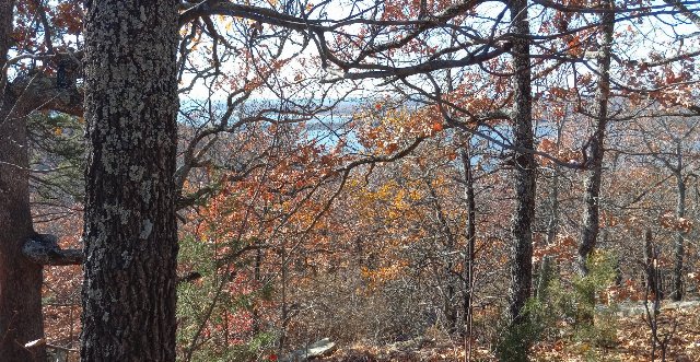 This landscape shows an overlook of Keystone Lake on the Arkansas River from Keystone Ancient Forest, Oklahoma. This is one of the few old growth forests in this region, with some trees from 300 to 500 years of age, although most of the vegetation is much younger. As this region is towards the drier end of where forests can survive, the trees tend to be shorter and the canopy more open than forests farther east. Photo © J. Mahurin, CC BY 4.0.
Plant Lists & In-Region Search
We do not yet have data to generate plant lists for a region as fine-tuned as this one. However you can move up to the broader Cross Timbers and generate lists for that region: native plants or all plants. Or search that region's plants here: