
Home » Regions » North America » Eastern Temperate Forests » Ozark, Oauchita-Appalachian Forests » Arkansas Valley » Scattered High Ridges and Mountains
Scattered High Ridges and Mountains
Last updated: February 18th, 2021
Page contents
↑About the Scattered High Ridges and Mountains
The Scattered High Ridges and Mountains are are region representing isolated high-elevation areas of the Arkansas Valley, mostly located in Arkansas but extending slightly into eastern Oklahoma.This region consists of mountains, high ridges, and small plateaus that stand out markedly from their flatter surroundings. The landscape is diverse. Many of the plateaus are relatively unbroken, and in places, there is a terraced appearance to the landscape, as erosion-resistant layers form relatively flat regions surrounded by steep slopes descending to the next resistant layer. In other areas, where the most erosion-resistant layers have eroded away, the plateaus are dissected and the peaks and ridges have rounder tops. Elevations range from 400 feet to a peak of 2,753 feet (Mount Magazine, the highest point point between the Appalachians and Rocky Mountains), with local relief ranging from 50 to 1,000 feet, and plateaus can be found at elevations ranging from 1,000 to 2,600 feet. The bedrock is mostly sandstone and shale, and there is significant colluvium, coarse, unsorted sediments of the same rock that have been moved downhill by mass wasting, often along the steep slopes.
The climate here is humid and subtropical; precipitation varies significantly by elevation, and also decreases to the west, ranging from 46-62 inches annually throughout this region. Precipitation is seasonal and bimodal, being highest in May, lowest in winter and late summer, and also higher in late fall. The frost-free growing season ranges from 190-210 days. In spite of the high total rainfall, the dry summers and warmer temperatures can combine to create many environments where plant growth is limited by moisture availability.
This region supports a diverse array of forest types owing to the large number of microclimates throughout. Original forest cover here is poorly known. This area was probably originally covered mostly in oak-hickory forest and oak-hickory-shortleaf pine forest, but with considerable diversity from site to site.
As most of it is too steep to farm, this region is still mostly forested. Some land on gentler-sloping sites and some of the lower plateaus is utilized for pasture or hay. There are some smaller towns, mostly at lower elevations, but most of this region is sparsely populated. Current vegetation cover is a mix of closed-canopy forest, open forest, and savanna. Dominant trees include fire-tolerant upland oaks, especially post oak (Quercus stellata), along with hickories, loblolly pine (Pinus taeda), and shortleaf pine (Pinus echinata). Mount Magazine has a unique drought-adapted scrubland on its relatively flat top. North-facing slopes at mid-to-high elevations support more mesic forest communities, including beech-maple forests.
This region is mostly surrounded by the lower, flatter Arkansas Valley Plains. In one spot it directly borders the Arkansas River Floodplain, with steep cliffs. There is also an area to the south where it directly borders the Fourche Mountains. At the far west, it borders the Lower Canadian Hills. In the east, a section of it is bordered to the north by the still hilly but slightly lower-elevation and less rugged Arkansas Valley Hills.
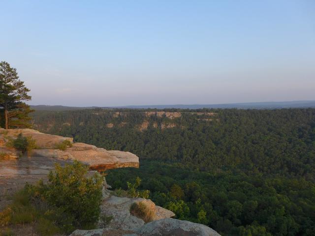 This photo taken from Red Bluff Drive in Petit Jean State Park in Arkansas shows the scattered high ridges and mountains of the Arkansas Valley, long, high ridges and plateaus with extensive bedrock outcroppings and often steep slopes, and extensive forest on the flatter terrain. Photo © Robert Thigpen, CC BY-SA 2.0, Source.
Plant Lists & In-Region Search
We do not yet have data to generate plant lists for a region as fine-tuned as this one. However you can move up to the broader Arkansas Valley and generate lists for that region: native plants or all plants. Or search that region's plants here:
↑References
1. Woods A.J., Foti, T.L., Chapman, S.S., Omernik, J.M., Wise, J.A., Murray, E.O., Prior, W.L., Pagan, J.B., Jr., Comstock, J.A., and Radford, M. "Ecoregions of Arkansas (Poster)", U.S. Geological Survey, Reston, VA (2004) Web.