
Home » Regions » North America » Eastern Temperate Forests » Ozark, Oauchita-Appalachian Forests » Arkansas Valley » Arkansas River Floodplain
Arkansas River Floodplain
Last updated: February 18th, 2021
Page contents
↑About the Arkansas River Floodplain
The Arkansas River Floodplain is a bottomland region along the Arkansas river, mostly located within Arkansas, but extending slightly into eastern Oklahoma. It is discontinuous, separated into four pieces, because the river alternates from having a floodplain in some places, to directly cutting through steep cliffs with little or no floodplain in other places. Two of these interruptions are natural, but two are due to dams which created two reservoirs, Lake Dardanelle in Arkansas, and the Robert S. Kerr reservoir in Oklahoma, both of which buried parts of this region under water.This region is fairly level, with floodplains and low terraces, natural levees, and abundant oxbow lakes, point bars, low, marshy lands, and backswamps, silt- and clay-rich bottomlands formed by past flooding events. This region is entirely underlain by deposits transported by the river.
The original vegetation of this area is not well-known, but was probably typical of southern floodplain forests, a mixed deciduous forest with bur oak (Quercus macrocarpa) and other bottomland oaks, American sycamore (Platanus occidentalis), American sweetgum (Liquidambar styraciflua), various willows, eastern cottonwood (Populus deltoides), green ash (Fraxinus pennsylvanica), pecan (Carya illinoinensis), common hackberry (Celtis occidentalis), elm, and understory grasses.
Most of this region has been cleared and drained. Areas that flood more frequently are mainly used for pastureland or hay production, whereas regions less prone to flooding grow soybeans, corn, rice, and small grains. There are a few remnants of deciduous forest on the most frequently-flooded or poorly-drained sites. Significant portions of this region have been entirely eliminated by the creation of the two large reservoirs. A third reservoir, Murray Lake, somewhat reduced the floodplain, but left some remaining on both banks of the river.
There are several large tracts of protected land here. Fairly centrally, Holla Bend National Wildlife Refuge preserves a large area south of the river; this area was artificially constructed by an Army Corps of Engineers project that channelized the river and created an artificial oxbow lake where the old channel had been. Across from this, the Galla Creek State Wildlife Management Area and the Sweeden Island Recreation Area preserve a smaller tract of land. At the far west of this region, Sequoyah National Wildlife Refuge is partly located within this region, and preserves another large tract of land. There is also a small protected area of forest at Fletcher Bend Public Use Area.
Most of this region is sparsely populated, because most urbanization in the broader region has been carried out on higher ground that is less flood-prone. However, the southeasternmost end of this region meets the Little Rock metro area, and this portion is heavily urbanized. Part of the city of Van Buren, and the entire town of Dardanelle are also located within this region.
This region is mostly surrounded by the Arkansas Valley Plains, except for one brief spot (northeast from Petit Jean State Park) where it directly borders the Scattered High Ridges and Mountains, in an abrupt border marked by cliffs. The western end of this region, a small fragment, directly borders the Osage Cuestas and the Lower Boston Mountains.
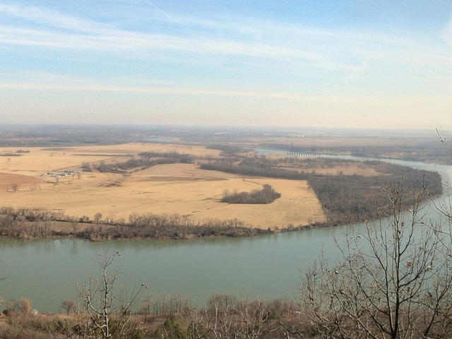 This photo of the Arkansas River, taken from Petit Jean State Park, shows one stretch of its floodplain, with some of the land used for agriculture but some left as wild forest. Crop of a photo © zak.holder@ymail.com (Flickr), CC BY 2.0, Source.
Plant Lists & In-Region Search
We do not yet have data to generate plant lists for a region as fine-tuned as this one. However you can move up to the broader Arkansas Valley and generate lists for that region: native plants or all plants. Or search that region's plants here:
↑References
1. Woods A.J., Foti, T.L., Chapman, S.S., Omernik, J.M., Wise, J.A., Murray, E.O., Prior, W.L., Pagan, J.B., Jr., Comstock, J.A., and Radford, M. "Ecoregions of Arkansas (Poster)", U.S. Geological Survey, Reston, VA (2004) Web.