
Home » Regions » North America » Northern Forests » Atlantic Highlands » Northeastern Highlands » Western New England Marble Valleys
Western New England Marble Valleys
Last updated: September 11th, 2020
↑About the Western New England Marble Valleys
The Western New England Marble Valleys are a narrow, irregularly-shaped set of valleys found in the far east part of New York State, northwestern Connecticut, Western Massachusetts, and southwestern Vermont. The regions mostly extend north-south, and tend to be surrounded by areas of higher elevation. These valleys include the Berkshire or Stockbridge valley in Massachussets, and the smaller Vermont valley.This region is mostly underlain by calcitic and dolomitic marble, water-soluble rocks that are easily eroded, producing the low, flat topography in an otherwise rugged, mountainous region. However, folding and faulting has caused some erosion-resistant rocks, including schist, gneiss, and quartzite, to be intermixed in this region, where they often form outcroppings and contribute to a slight irregularity in the landscape. The low elevations lead this region to have markedly milder temperatures and lower precipitation than the surrounding regions. Glacial drift is abundant, having accumulated here more than in nearby uplands. Elevations here range from 500 to 1,900 feet (152-579m) Soils here tend to be deep, coarse, and well-drained.
Natural forest cover ranges from northern hardwoods to transitional (between northern hardwood and oak-hickory forests). Originally this area was almost completely forested, with a few open wetlands. Some of these wetlands still exist.
This area has more agriculture than any of the surrounding uplands, which have virtually none. The wide, flat valley bottoms contain abundant farms interspersed with small fragments of forest; forest cover increases as one ascends to higher elevations. The region is not densely populated, although more populous than the surroundings. The largest city is Pittsfield, MA.
Throughout much of this region it is bordered to the east by the Green Mountains/Berkshire Highlands and to the west by the Taconic Mountains. At the south a small region is bordered to the east by the Lower Berkshire Hills, and south of that, by the Berkshire Transition, and to the west by the Taconic Foothills. The very north of this region transitions gradually to the Champlain Lowlands, a region covered by glacial lake sediments.
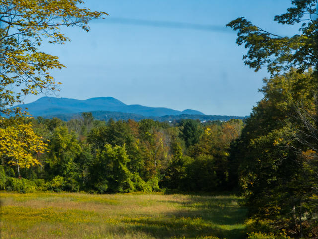 This photo shows a landscape near Pittsfield, MA, with Mt. Greylock in the background. The scene, typical of the Marble Valleys, is low and flat, but surrounded by mountains. This is a crop of a photo © Jim Lukach, CC BY 2.0, Source.
Plant Lists & In-Region Search
We do not yet have data to generate plant lists for a region as fine-tuned as this one. However you can move up to the broader Northeastern Highlands and generate lists for that region: native plants or all plants. Or search that region's plants here:
↑References
1. Griffith, G.E., Omernik, J.M., Bryce, S.A., Royte, J., Hoar, W.D., Homer, J.W., Keirstead, D., Metzler, K.J., and Hellyer, G. "Ecoregions of New England (Poster)", U.S. Geological Survey (2009) Web.
2. Bryce, S.A., Griffith, G.E., Omernik, J.M., Edinger, G., Indrick, S., Vargas, O., and Carlson, D. "Ecoregions of New York (Poster)", U.S. Geological Survey (2010) Web.