
Home » Regions » North America » Northern Forests » Atlantic Highlands » Northeastern Highlands » Green Mountains/Berkshire Highlands
Green Mountains/Berkshire Highlands
Last updated: November 13th, 2021
Page contents
↑About the Green Mountains/Berkshire Highlands
The Green Moutains and Berkshire Highlands are a region oriented north-south, mostly located in western Vermont, with a significant portion in Western Massachusetts, and a tiny part stretching north into Quebec. This region is a single geologically and ecologically well-defined, but the northern and southern portions of it are locally referred to with two distinct names. The portion of this region located in Vermont is typically referred to as the "Green Mountains" whereas the portion in Massachusetts is typically referred to as the "Berkshires" or "Berkshire Mountains".This region consists of rugged, steep mountains. Elevations range from 600-3,369 feet and local relief ranges from 1,000-2,500 feet; this region excludes the highest elevations, which are separated into the Upper Montane / Alpine Zone. The underlying geology is complex, but consists mostly of metamorphic rocks, with a thin and discontinuous layer of glacial till. Bedrock is exposed in many areas. Soils in most areas are acidic, coarse, well-drained, and the surface layer is highly leached, but a few areas have narrow bands of calcium-rich rocks, leading to local soils more buffered against acidity. There are also a few bands of serpentine, which inhibit plant growth.
The area has a humid continental climate, considerably colder than surrounding lower-elevation areas, but also varying considerably both by elevation and over the north-south length of this region. The frost-free growing season ranges from 90-135 days.
Lower slopes support northern hardwood or mesic red oak-northern hardwood forests, with dominant trees being sugar maple (Acer saccharum), American beech (Fagus grandifolia), yellow birch (Betula alleghaniensis), and northern red oak (Quercus rubra). There are some areas of northern hardwoods-hemlock-white pine forest, with the addition of eastern hemlock (Tsuga canadensis) and eastern white pine (Pinus strobus). Richer sites feature northern hardwoods with the addition of white ash (Fraxinus americana), American basswood (Tilia americana), butternut (Juglans cinerea), and sweet birch (Betula lenta). Mid-slopes and low summits feature montane forests of yellow birch and red spruce (Picea rubens), with some sugar maple, red maple (Acer rubrum), and American beech. Plateau witlands have spruce-fir-tamarack swamp, with red spruce, black spruce (Picea mariana), balsam fir (Abies balsamea), tamarack (Larix laricina), red maple, and mountain holly (Ilex montana). The highest elevations have some subalpine balsam fir-birch forest, and a few small areas of spruce-fir forest.
Like most of New England, this region is nearly all second-growth forest, but there is a small portion of old-growth forest left at Gifford Woods State Park, featuring sugar maple, beech, yellow birch, white ash, and hemlock.
This area is sparsely populated, but there are a few towns, including Killington, Waterbury, and Stowe in Vermont, and Charlemont, MA. There is a small amount of agriculture, mostly in valley and lower, flatter areas, mostly livestock grazing, dairy farming, and hay production. In the rest of the region, there is forestry, maple syrup production, and tourism and recreation. This region has a significant portion of public land, including both national forest, state forests, and state parks.
This region is bordered to the east by the slightly lower, slightly less rugged Vermont Piedmont and to the northeast by the Northern Piedmont. The south and central portions of this region are bordered to the west by the low-lying, agriculturally-fertile Western New England Marble Valleys. The southern end of this region, in Masachusetts, is bordered to the south by the Lower Berkshire Hills and to the southeast by the Berkshire Transition. The northern end of this region is bordered to the west by the Green Mountain Foothills, and south of that, there is a region where it opens up directly to the west to the Champlain Lowlands.
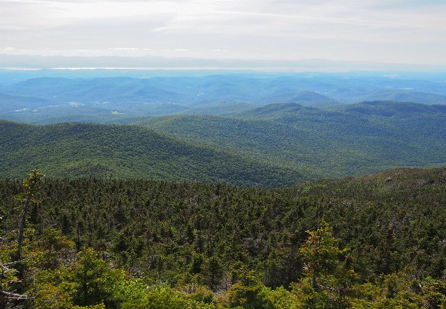 This view from Camels Hump, Vermont, shows a forested landscape typical of the Green Mountains, with fairly rugged mountains, but with most summits staying below the tree line. Photo © Wesley Carr, CC BY 2.0, Source.
Plant Lists & In-Region Search
We do not yet have data to generate plant lists for a region as fine-tuned as this one. However you can move up to the broader Northeastern Highlands and generate lists for that region: native plants or all plants. Or search that region's plants here:
↑References
1. Griffith, G.E., Omernik, J.M., Bryce, S.A., Royte, J., Hoar, W.D., Homer, J.W., Keirstead, D., Metzler, K.J., and Hellyer, G. "Ecoregions of New England (Poster)", U.S. Geological Survey (2009) Web.