
Home » Regions » North America » Northern Forests » Atlantic Highlands » Northeastern Highlands » Berkshire Transition
Berkshire Transition
Last updated: April 9th, 2021
↑About the Berkshire Transition
The Berkshire Transition represents an area in northwestern Connecticut and the southern half of western Massachussets that is transitional between the lower-elevation regions to the south and east, and the higher-elevation regions farther northwest. It shares some characteristics in common with the southern end of the Vermont Piedmont, and others with the Glaciated Reading Prong to the southwest, a region it does not directly border.The underlying geology is diverse, consisting of a mix of limestone and other calcium-rich bedrock, schist, quartzite, and some gneiss. Some areas have dense glacial till, but the presence and amount of till is inconsistent. Variation in bedrock creates changes in terrain as well as soil type and stream alkalinity. Soils formed on glacial till are poorly-drained. Elevations here range from 400 to 1,700 feet (122-518m)
Natural forest cover here was and still is diverse, owing both to differences in slope aspect and soil type. Dry to mesic north-facing slopes and ravines supported northern hardwoods-hemlock-white pine forests, with dominant trees being sugar maple (Acer saccharum), white ash (Fraxinus americana), yellow birch (Betula alleghaniensis), American beech (Fagus grandifolia), black cherry (Prunus serotina), northern red oak (Quercus rubra), bitternut hickory (Carya cordiformis), eastern hemlock (Tsuga canadensis), and eastern white pine (Pinus strobus). Mesic mid slopes supported a transitional forest with northern red oak and sugar maple, beech, sweet birch (Betula lenta), and some white pine and hemlock. Warmer sites supported oak-hemlock-white pine forest, with white oak (Quercus alba), chestnut oak (Quercus montana), northern red oak, sweet birch, black cherry, and red maple (Acer rubrum), with some hemlock and white pine. Some of the driest ridgetops supported scrubby growth of pitch pine (Pinus rigida), northern red oak, black oak (Quercus velutina), and scarlet oak (Quercus coccinea). Slopes along streams and adjacent terraces supported red maple, silver maple (Acer saccharinum), American elm (Ulmus americana), American basswood (Tilia americana), sugar maple, shagbark hickory (Carya ovata), and black cherry.
The original forests were mostly cleared by European settlers, and for a while, most of the land was cultivated, but agriculture has been declining here for some time. Some agriculture remains, although less than in flatter, lower-elevation regions. The area is mostly sparsely populated; Torrington, CT is the only city of any significant size. Most of the region is currently forested, although almost none of it is old-growth. A tiny (42-acre) preserve containing a small amount of old growth exists at Cathedral Pines in Cornwall, CT. The forest composition has changed somewhat, with American elm having been reduced due to Dutch elm disease, and now white ash is threatened by the emerald ash borer. Forests here are in different stages of succession, but on the whole early-successional species such as black cherry, red maple, paper birch (Betula papyrifera), and quaking aspen (Populus tremuloides) are more common nowadays.
This region is bordered to the east by the much flatter, lower-elevation, and more fertile Connecticut Valley and to the south by the slightly flatter and lower-elevation Southern New England Coastal Plains and Hills. At the north, this region is bordered by the geologically similar but climactically colder Vermont Piedmont. In the south of this region, it is bordered to the west by the low-lying Western New England Marble Valleys, but farther north it is bordered by the higher-elevation Lower Berkshire Hills, and north of that, by the Green Mountains/Berkshire Highlands.
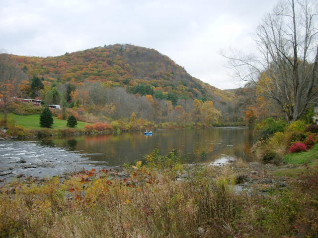 This photo shows the housatonic river in West Cornwall, CT, winding through a hilly landscape covered in mostly-deciduous forests, typical of this region. This is an edit (adjusting colors/lighting) of a photo © Doug Kerr, CC BY-SA 2.0, Source.
Plant Lists & In-Region Search
We do not yet have data to generate plant lists for a region as fine-tuned as this one. However you can move up to the broader Northeastern Highlands and generate lists for that region: native plants or all plants. Or search that region's plants here:
↑References
1. Griffith, G.E., Omernik, J.M., Bryce, S.A., Royte, J., Hoar, W.D., Homer, J.W., Keirstead, D., Metzler, K.J., and Hellyer, G. "Ecoregions of New England (Poster)", U.S. Geological Survey (2009) Web.
2. Bryce, S.A., Griffith, G.E., Omernik, J.M., Edinger, G., Indrick, S., Vargas, O., and Carlson, D. "Ecoregions of New York (Poster)", U.S. Geological Survey (2010) Web.