
Home » Regions » North America » Northern Forests » Atlantic Highlands » Northeastern Highlands » Western Maine Foothills
Western Maine Foothills
Last updated: August 24th, 2020
Page contents
↑About the Western Maine Foothills
The Western Maine Foothills is an inland region in western Maine representing a transition from higher-elevation and more rugged areas to the northwest and lower, flatter areas to the southeast.This region consists of open, low mountains and foothills of the higher mountains to the northwest. Elevations range from 400 to 3,187 feet with local relief of 400-2,000 feet. There are moderate to high-gradient streams, and some small to medium lakes and wetlands scattered throughout. The bedrock consists of metamorphosed sandstone and finer-grained sedimentary rocks, with significant intrusions of igneous rocks, which are in turn covered in sandy glacial till and, in the south, some thin glacial drift as well. Soils here tend to be coarse-textured, acidic, and with a surface layer highly leached of nutrients. Except in low, flat areas, the region is poorly suited to agriculture, and the wild ecosystems here support less diversity of woody plants than areas south and east.
This region has vegetation intermediate between temperate and boreal forests. Original cover was probably a mix of several forest types at low-to-mid elevations: northern hardwood forest featured Sugar Maple (Acer saccharum), American Beech (Fagus grandifolia), and Yellow Birch (Betula alleghaniensis), and red oak-northern hardwood-white pine forest, had those same species along with Northern Red Oak (Quercus rubra) and Eastern White Pine (Pinus strobus). There were also white pine - mixed conifer forests, with white pine, red spruce (Picea rubens), Eastern Hemlock (Tsuga canadensis) and Red Maple (Acer rubrum), and hemlock forests with hemlock as dominant tree, along with red spruce, northern red oak, and red maple. Coves and richer, more sheltered sites featured sugar maple, yellow birch, American Basswood (Tilia americana), and various ash species (white, green, black). The highest-elevation sites were covered with red spruce, Balsam Fir (Abies balsamea), and birches.
This region is still mostly forested; there is significant forestry, including pulp and paper production. There is also some recreation, and a small amount of pasture and cropland, mostly in the larger river valleys. This region is mostly sparsely populated; the town of Farmington lies along the southeastern border of this region; the largest town entirely contained in this region is Rumford, whose economy revolves around a paper mill and ski resort.
To the south, this region borders the Sebago-Ossipee Hills and Plains. To the northwest lie the higher-elevation and more rugged White Mountains/Blue Mountains. To the east lies the Central Maine Embayment, and in the far northeast there is a small border with the Quebec/New England Boundary Mountains.
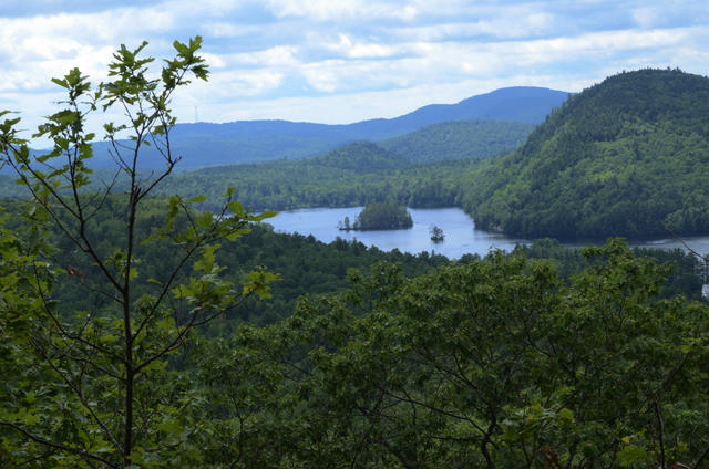 This photo, taken from the View from Lapham Ledge near Woodstock, Maine, shows rugged, steep hills that cover this region. These forests have significant portions of red oak. Photo © Mark Nenadov, CC BY 2.0, Source.
Plant Lists & In-Region Search
We do not yet have data to generate plant lists for a region as fine-tuned as this one. However you can move up to the broader Northeastern Highlands and generate lists for that region: native plants or all plants. Or search that region's plants here:
↑References
1. Griffith, G.E., Omernik, J.M., Bryce, S.A., Royte, J., Hoar, W.D., Homer, J.W., Keirstead, D., Metzler, K.J., and Hellyer, G. "Ecoregions of New England (Poster)", U.S. Geological Survey (2009) Web.