
Home » Regions » North America » Northern Forests » Atlantic Highlands » Northeastern Highlands » Quebec/New England Boundary Mountains
Quebec/New England Boundary Mountains
Last updated: July 25th, 2020
Page contents
↑About the Quebec/New England Boundary Mountains
The Quebec/New England Boundary Mountains are a mountain range that extend along the boundary between Quebec and New England, from northeastern Vermont and northern New Hampshire and into central Maine, and in bordering regions of Quebec. This region overlaps partly with what is called the Longfellow Mountains, a name attributed by the Maine legislature in 1959.This region consists of open, low mountains with numerous large lakes and ponds. Elevations are slightly lower and slopes slightly less steep than the White Mountains to the south. The underlying geology is complex, with bedrock consisting of weakly-metamorphosed sedimentary rocks of various types, igneous intrusions, and ancient formations of precambrian gneiss. Atop this is sandy-loamy glacial till, gravely outwash, and drift.
The climate is towards the colder end of a humid continental climate, and is the coldest of any part of New England; the frost-free season ranges from 85-125 days. Because of the cold winter temperatures, less total precipitation falls in winter, but moisture availability is high year-round.
This region was naturally covered mostly in coniferous and mixed forests, with some deciduous forests. Lowlands had spruce-fir forest with red spruce, balsam fir, paper birch, yellow birch, and eastern white pine. Poorly drained areas featured northern white cedar swamps, and black spruce and tamarack in bogs. Low and mid elevations supported northern hardwood forests with sugar maple, American beech, and yellow birch.
High elevations had a slightly different spruce-fir forest, with red spruce (Picea rubens), balsam fir (Abies balsamea), mountain paper birch (Betula cordifolia), paper birch (Betula papyrifera), and yellow birch (Betula alleghaniensis), and an understory including striped maple (Acer pensylvanicum), mountain maple (Acer spicatum), velvetleaf huckleberry (Vaccinium myrtilloides), bunchberry dogwood (Cornus canadensis), creeping snowberry (Gaultheria hispidula), woodferns (Dryopteris sp.), mountain woodsorrel (Oxalis montana), canada mayflower (Maianthemum canadense), and an abundance of mosses and liverworts. The highest elevations featured fir-birch subalpine forests, with balsam fir, heartleaf birch, and mountain ash (Sorbus sp.)
This area is still extensively forested, mostly in second-growth forests. There is almost no agriculture here, only a tiny amount in the southernmost part of this region. Land use is mostly forestry, recreation, hunting and fishing, and maple syrup production. The region is sparsely populated, with only a few villages centered around tourism and industry. The eastern portion of this region contains many protected public lands. The massive Baxter State Park is mostly included within this region, and contains one of the largest old-growth forests in the eastern U.S., mostly of balsam fir.
The southwestern portion of this region, in Vermont, is bordered to the west and south by the Northern (Vermont) Piedmont. The northernmost end of the Northern Connecticut Valley cuts through this region along the border of Vermont and New Hampshire. There is a small border with the White Mountain Foothills to the south, but most of this region is bordered to the south by the White Mountains/Blue Mountains.
In the eastern portion of this region, there are small borders to the south with the Western Maine Foothills and Central Maine Embayment, but most of the region is bordered to the southeast by the Central Foothills. At the far northeast, this region borders the Aroostook Hills, and west of that, there are two borders with the St. John Uplands to the north, and between them, this region partly surrounds the irregularly-shaped Moosehead-Churchill Lakes. The highest elevations of this region are treated separately as part of the Upper Montane/Alpine Zone.
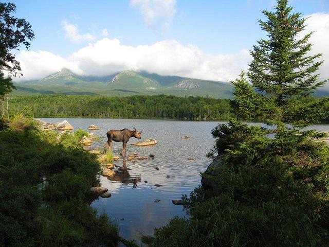 This photo shows Sandy Stream Pond in Baxter State Park. The landscape of ponds or lakes surrounded by hills and mountains is typical of this region. Photo © Elizabeth Byrd Wood, CC BY-SA 2.0, Source.
Plant Lists & In-Region Search
We do not yet have data to generate plant lists for a region as fine-tuned as this one. However you can move up to the broader Northeastern Highlands and generate lists for that region: native plants or all plants. Or search that region's plants here:
↑References
1. Griffith, G.E., Omernik, J.M., Bryce, S.A., Royte, J., Hoar, W.D., Homer, J.W., Keirstead, D., Metzler, K.J., and Hellyer, G. "Ecoregions of New England (Poster)", U.S. Geological Survey (2009) Web.