
Home » Regions » North America » Northern Forests » Atlantic Highlands » Northeastern Highlands » Sebago-Ossipee Hills and Plains
Sebago-Ossipee Hills and Plains
Last updated: July 30th, 2020
Page contents
↑About the Sebago-Ossipee Hills and Plains
The Sebago-Ossipee Hills and Plains are a relatively large, roundish region extending from eastern New Hampshire, northeast into southwestern Maine. This region can be seen as transitional between the Northeastern Highlands, which it is included as part of, and the milder Northeastern Coastal Zone to the southeast.This region consists of glaciated rolling plains, with some hills and low mountains. There are also numerous glacial features, including kames and eskers, and numerous wetlands and lakes, including the large Sebago Lake in Maine and Lake Winnipesaukee in New Hampshire (and the surrounding Lakes Region). Elevations mostly range from 300-1,200 feet, but peaks reach up to 2,875 feet. Local relief ranges from 250-1,800 feet. Soils here tend to be well-drained and drier than most of the Northeast Highlands.
This region was originally mostly covered in transitional white pine-mixed hardwood forests. Overall, this region supported more oaks and some pine species absent from cooler, higher-elevation regions to the north and west.
White pine-mixed conifer forests featured eastern white pine (Pinus strobus), red spruce (Picea rubens), eastern hemlock (Tsuga canadensis), and red maple (Acer rubrum). There was some red oak-northern hardwoods-white pine forest, and some beech-birch-maple forest, featuring American beech (Fagus grandifolia), yellow birch (Betula alleghaniensis), and sugar maple (Acer saccharum), with some paper birch (Betula papyrifera) and striped maple (Acer pensylvanicum). There was also oak-pine forest, with northern red oak (Quercus rubra), eastern white pine, and red maple, and some red pine-white pine-balsam fir forest, as well as some pitch pine-scrub oak woodlands. Floodplains featured silver maple (Acer saccharinum) floodplain forests.
This region is currently largely forested, but there is still scattered pastureland and cropland, with the largest concentration near Fryeburg, ME. The forest cover reflects a large-scale abandonment of agriculture, typical of New England. There is also rural residential development here, as well as recreation and tourism, and forestry. This lakes of this region are an important source of drinking water, with Sebago Lake providing drinking water for nearly one-sixth of Maine's population.
This area shares borders with many different regions. In Maine, it is bordered to the north by the Western Maine Foothills. It has a slightly longer border to the northwest, over most of its length, with the much higher-elevation and colder White Mountains/Blue Mountains. To the west, there is a small border with the White Mountain Foothills, and south of that, the Sunapee Uplands. There is a slightly longer border to the southwest with the Worcester/Monadnock Plateau, and to the southeast with the Gulf of Maine Coastal Plain. At the eastern portion of this region, there is also a small border to the southeast directly with the Gulf of Maine Coastal Lowland.
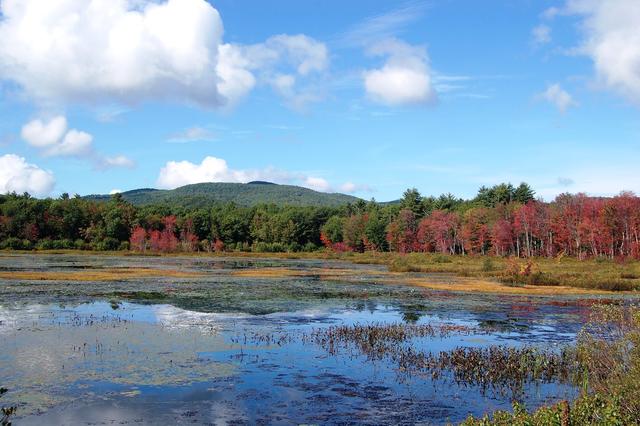 This photo shows a lake and surrounding landscape near Hiram, Maine. This region is hilly and has numerous wetlands and lakes of glacial origin. The forest edge shows numerous white pines and hardwoods, already changing color in mid-September. Photo © InAweofGod'sCreation (Flickr), CC BY 2.0, Source.
Plant Lists & In-Region Search
We do not yet have data to generate plant lists for a region as fine-tuned as this one. However you can move up to the broader Northeastern Highlands and generate lists for that region: native plants or all plants. Or search that region's plants here:
↑References
1. Griffith, G.E., Omernik, J.M., Bryce, S.A., Royte, J., Hoar, W.D., Homer, J.W., Keirstead, D., Metzler, K.J., and Hellyer, G. "Ecoregions of New England (Poster)", U.S. Geological Survey (2009) Web.