
Home » Regions » North America » Eastern Temperate Forests » Mixed Wood Plains » Northeastern Coastal Zone » Boston Basin
Boston Basin
Last updated: August 26th, 2020
Page contents
↑About the Boston Basin
The Boston Basin is a geologically well-defined area that mostly coincides with the Boston metro area. It is located entirely within Massachusetts.This area is underlain by sedimentary rocks, mostly argillite and conglomerate, contrasting with the metamorphic rocks of neighboring regions. This substrate is more easily eroded than the surroundings, and has resulted in the erosion of a basin that is open to the ocean, with more estuaries, bays, and islands than are in the bordering coastal areas. The geology here is diverse; in addition to sedimentary rocks there are some metamorphic and volcanic rocks, and atop the bedrock, glacial till of sand and gravel. The topography is flatter towards the center of this region, and hillier around the border of this region. Much of the region consists of irregular plains, moving into rolling hills around the periphery.
The climate is intermediate between a humid continental climate and a humid subtropical climate. Precipitation is high year-round, roughly equally distributed throughout the year but highest in March. The low altitude and proximity to the ocean has a moderating effect on the climate, and its location makes it particularly susceptible to Nor'easters, winter storms originating in the north Atlantic. Urban heat island effect makes this region consistently warmer than it would naturally be, allowing more southerly species to persist and thrive here. The frost-free growing season is 210-220 days, the longest anywhere in New England. This region also is among the sunniest locations in New England, receiving more total sunshine than areas to the west and southeast.
This area is heavily urbanized and little forest remains. Remaining forest is mostly oak-hickory forest, or white pine-oak forest, featuring white oak (Quercus alba), northern red oak (Quercus rubra), black oak (Quercus velutina), and scarlet oak (Quercus coccinea). Coastal areas support some maritime shrubland, with huckleberry, northern bayberry (Morella pensylvanica), and eastern redcedar (Juniperus virginiana). Coastal dunes feature American beachgrass (Ammophila breviligulata), seaside goldenrod (Solidago sempervirens), and beach pea (Lathyrus japonicus). Salt marshes feature smooth cordgrass (Spartina alterniflora), saltmeadow cordgrass (Spartina patens), and saltgrass (Distichlis spicata). The islands in the Boston harbor are mostly dominated by introduced species, and this area in general has a greater portion of introduced species because of the influence of escaped landscaping plants and the smaller portion of intact wild areas. Forest cover is greatest in the lower-density suburban areas around the borders of this area.
This region is bordered both to the north and south along the coast by the less intensely urbanized Gulf of Maine Coastal Lowland. To the southwest, the region borders the more rugged and sparsely-populated Southern New England Coastal Plains and Hills. To the west and northwest, this region borders the Gulf of Maine Coastal Plain.
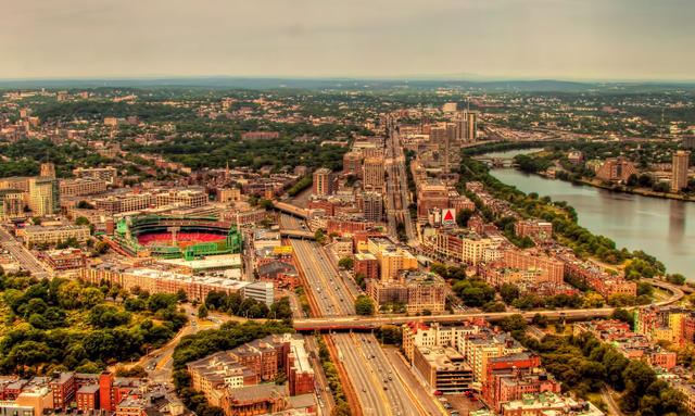 The city of Boston takes up much of the Boston Basin; what little wild greenspace remains is mostly around the edge of the basin, visible as the portion of green increases in the distance. Photo © Navaneeth KN, CC BY 2.0, Source.
Plant Lists & In-Region Search
We do not yet have data to generate plant lists for a region as fine-tuned as this one. However you can move up to the broader Northeastern Coastal Zone and generate lists for that region: native plants or all plants. Or search that region's plants here:
↑References
1. Griffith, G.E., Omernik, J.M., Bryce, S.A., Royte, J., Hoar, W.D., Homer, J.W., Keirstead, D., Metzler, K.J., and Hellyer, G. "Ecoregions of New England (Poster)", U.S. Geological Survey (2009) Web.