
Home » Regions » North America » Eastern Temperate Forests » Mixed Wood Plains » Northeastern Coastal Zone » Southern New England Coastal Plains and Hills
Southern New England Coastal Plains and Hills
Last updated: February 27th, 2020
↑About the Southern New England Coastal Plains and Hills
The Southern New England Coastal Plains and Hills is a region in New England, making up much of the southern part of the Northeastern Coastal Zone. It extends through a tiny part of New York State, through most of Connecticut, northwestern Rhode Island, and southeastern Massachussets. It does not extend the whole way to the coast in any area.This region is a hilly, irregular plain, underlain by metamorphic bedrock (gneiss and schist), and shaped by glaciation and covered in glacial till and outwash. The climate is humid and continental, with four well-defined seasons and roughly equal precipitation year-round. Precipitation is quite high, especially for a climate as cold as this one. Relative to the coastal zone to the south, precipitation is slightly higher and temperatures slightly less moderate, but this region is markedly warmer than more mountainous areas farther inland.
Original forest cover here was a mix of oaks, American chestnut (Castanea dentata), eastern hemlock (Tsuga canadensis), and eastern white pine (Pinus strobus). These forests were nearly all cleared, and the area was extensively used for agriculture and grazing. Recently, however, agriculture has declined, but urbanization and suburban residential development has increased, and some land has also reverted to forest. This land tends to have less urban development than the bordering coastal zone to the south and east, and less than in the Connecticut Valley, but more than in mountainous areas farther inland. The largest cities are Waterbury, CT and Danbury, CT, and there is also some more diffuse suburban development in the portion of this region between Boston, MA and Providence, RI.
A small amount of old growth, mostly hemlock and some eastern white pine, can be found at the White Memorial Foundation Conservation Center near Litchfield, CT.
This region is bordered to the south by the Long Island Sound Coastal Lowland. It is separated into two pieces by the Connecticut Valley. It also borders the Narragansett/Bristol Lowland to the southeast, and the Gulf of Maine Coastal Lowland to the east along the coast. West of that, it is bordered to the north by the Boston Basin and inland of that by the Gulf of Maine Coastal Plain. Between there and the Connecticut Valley it is bordered to the north by the Lower Worcester Plateau/Eastern Connecticut Upland. West of the Connecticut Valley it is bordered to the north by the Berkshire Transition, and at its westernmost part it is bordered to the north by the Glaciated Reading Prong / Hudson Highlands and to the west by the Glaciated Triassic Lowlands.
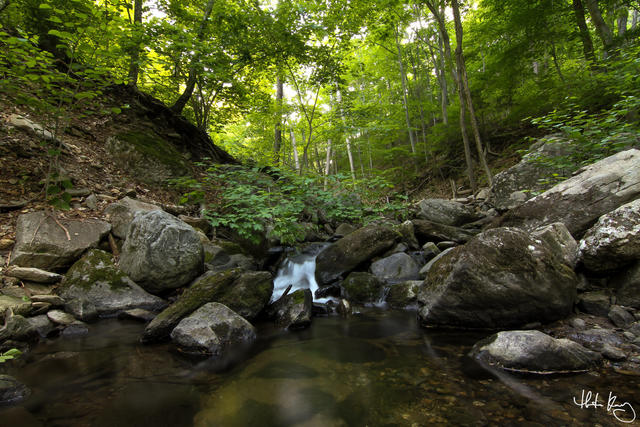 This photo shows a stream at Indian Well State Park in Connecticut. The rocky soils, hilly topography, and rich deciduous forests are typical of this region. Photo © Trenten Kelley, CC BY-ND 2.0, Source.
Plant Lists & In-Region Search
We do not yet have data to generate plant lists for a region as fine-tuned as this one. However you can move up to the broader Northeastern Coastal Zone and generate lists for that region: native plants or all plants. Or search that region's plants here:
↑References
1. Griffith, G.E., Omernik, J.M., Bryce, S.A., Royte, J., Hoar, W.D., Homer, J.W., Keirstead, D., Metzler, K.J., and Hellyer, G. "Ecoregions of New England (Poster)", U.S. Geological Survey (2009) Web.
2. Bryce, S.A., Griffith, G.E., Omernik, J.M., Edinger, G., Indrick, S., Vargas, O., and Carlson, D. "Ecoregions of New York (Poster)", U.S. Geological Survey (2010) Web.