
Home » Regions » North America » Northern Forests » Atlantic Highlands » North Central Appalachians » Glaciated High Allegheny Plateau
Glaciated High Allegheny Plateau
Last updated: February 23rd, 2021
Page contents
↑About the Glaciated High Allegheny Plateau
The Glaciated High Allegheny Plateau is a small portion of the high Allegheny Plateau, towards its easternmost end, that was glaciated in the recent Wisconsin glaciation. It is located entirely within Pennsylvania, extending east from the north-central part of the state in five finger-shaped bulges with lower-elevations in between them.Like its unglaciated counterpart, this region is a deeply-dissected plateau, but it has had its terrain smoothed somewhat by glaciation. The underlying substrate consists of erosion-resistant sedimentary rocks underneath acidic glacial drift. The drift creating soils that are rocky, acidic, and low in nutrients. Ridges are mostly made of sandstone. Glacial melt created some natural lakes, and lakes and wetlands are more common here than regions to the west.
The climate here is a humid continental climate, slightly warmer and with slightly lower precipitation than the areas to the west, but still with a short growing season. Precipitation is lowest in the northwest of this region and highest in the southeast. The poor soil, steep topography, and short growing season make this region poorly-suited to Western agriculture.
Original vegetation cover was mostly northern hardwood forests, with some bogs, swamps, and marshes.
This area has little agriculture, and in general, little human land use. There is some recreational hunting, with significant Pennsylvania state game lands in this region. This area is sparsely populated, although there are a few towns located in valleys.
This region is bordered to the northeast and interspersed with the lower-elevation, warmer, and more arable Glaciated Low Allegheny Plateau. To the southwest it borders the Unglaciated High Allegheny Plateau. In a few spots, it shares small borders to the south with the Northern Dissected Ridges and Knobs.
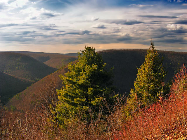 This photo shows the Pine Creek Gorge in Tioga County, from the Mid State Trail at Gillespie Point, which illustrates the typical landscape in this region. The hills are steep but smooth, and the forests are mostly deciduous but with some conifers. Photo © Nicholas A. Tonelli, CC BY 2.0, Source.
Plant Lists & In-Region Search
We do not yet have data to generate plant lists for a region as fine-tuned as this one. However you can move up to the broader North Central Appalachians and generate lists for that region: native plants or all plants. Or search that region's plants here:
↑References
1. Woods, A.J, Omernik, J.M., Brown, D.D. "Level III and IV Ecoregions of Delaware, Maryland, Pennsylvania, Virginia, and West Virginia", U.S. Environmental Protection Agency: National Health and Environmental Effects Research Laboratory, Corvallis, OR (1999) Web.