
Home » Regions » North America » Northern Forests » Atlantic Highlands » North Central Appalachians » Unglaciated High Allegheny Plateau
Unglaciated High Allegheny Plateau
Last updated: February 23rd, 2021
↑About the Unglaciated High Allegheny Plateau
The Unglaciated High Allegheny Plateau is a large region in northern Pennsylvania, extending slightly into southwestern New York state. It represents most of the high Allegheny plateau, as only a small portion of it to the northeast was glaciated in the recent Wisconsin glaciation.The terrain here is rugged, consisting of a deeply dissected plateau with rounded hills, low mountains, and narrow valleys. Hilltop elevations tend to increase towards the north of this region. Although not directly glaciated, this region was affected by glacial melt water, which cut some deep valleys, creating local relief up to 1,300 feet (just under 400m) in some areas. The westernmost portions were glaciated in at least two, older glacial periods. Soils throughout the region tend to be rocky, nutrient-poor, and acidic.
The climate is a humid continental climate; compared to the surroundings, precipitation is higher, temperaures are cooler, and the growing season shorter. Precipitation here is seasonal, with more total rain falling in summer, but tending to be concentrated in large storms; rainy or snowy days are more common in winter, but tend to drop less total precipitation. Precipitation is highest towards the west, owing to moisture from the great lakes and the west-to-east motion of most weather systems here.
The original forest cover here was mostly northern hardwood forest, with sugar maple (Acer saccharum), yellow birch (Betula alleghaniensis), American beech (Fagus grandifolia), and eastern hemlock (Tsuga canadensis) as dominant trees. Conifers were present, and more common at higher elevations, but not dominant. There were naturally some bogs, and some Appalachian oak forest on warmer, drier sites such as south-facing slopes at lower elevations, more common around the warmer perimeters of this region.
Extensive agriculture and burning removed most of the original forest, but there are a few tracts of old growth forest remaining. Due to the cold climate and poor soils, agriculture was abandoned faster and more completely here than in surrounding regions. The forest cover has regrown, now almost entirely covering this region, but its composition is different, with dominant trees now being oaks, maples, and a mix of other hardwoods, with some eastern hemlock, pitch pine (Pinus rigida), and eastern white pine (Pinus strobus). There is significant protected public land here: Allegheny National Forest covers over 500,000 acres here, and there are numerous state forests and state game lands.
Oil wells are common in this region, which makes up about half of Pennsylvania's total oil production. There is also some surface coal mining in the south, although less than in other regions. Valleys in the northeast have a small amount of agriculture, but overall agriculture here is minimal. Pollution from oil wells and mine drainage is a major problem in some localities. This region is also used for hunting and recreation, but less intensely than other parts of the state, owing to its greater distance from population centers. Most of the region is sparsely populated but there are some small cities and towns, the largest of which are St. Mary's, followed by Warren and Bradford.
The eastern portion of this region is bordered to the northeast by its glaciated counterpart, the Glaciated High Allegheny Plateau, and to the south by the Northern Dissected Ridges and Knobs. Farther northwest, this region is bordered to the northeast by the Glaciated Allegheny Hills. To the northwest, this region borders the low, flat Low Lime Drift Plain. To the southwest, it borders the slightly lower, less rugged Pittsburgh Low Plateau, and east of that, the Uplands and Valleys of Mixed Land Use.
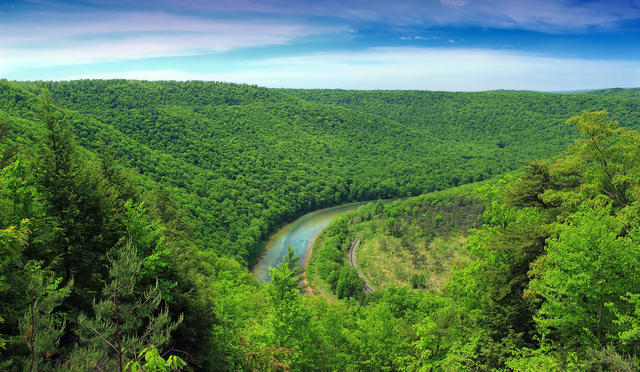 This view of the West Branch Susquehanna River in Sproul State Forest, Centre County shows a forested landscape typical of the unglaciated high Allegheny plateau. Photo © Nicholas A. Tonelli, CC BY 2.0, Source.
Plant Lists & In-Region Search
We do not yet have data to generate plant lists for a region as fine-tuned as this one. However you can move up to the broader North Central Appalachians and generate lists for that region: native plants or all plants. Or search that region's plants here:
↑References
1. Bryce, S.A., Griffith, G.E., Omernik, J.M., Edinger, G., Indrick, S., Vargas, O., and Carlson, D. "Ecoregions of New York (Poster)", U.S. Geological Survey (2010) Web.
2. Woods, A.J, Omernik, J.M., Brown, D.D. "Level III and IV Ecoregions of Delaware, Maryland, Pennsylvania, Virginia, and West Virginia", U.S. Environmental Protection Agency: National Health and Environmental Effects Research Laboratory, Corvallis, OR (1999) Web.