
Home » Regions » North America » Eastern Temperate Forests » Mixed Wood Plains » Northern Allegheny Plateau » Glaciated Low Allegheny Plateau
Glaciated Low Allegheny Plateau
Last updated: March 27th, 2021
↑About the Glaciated Low Allegheny Plateau
The Glaciated Low Allegheny Plateau, sometimes referred to just as the Glaciated Low Plateau, is a region extending through much of southern upstate New York, and well into Pennsylvania.This region is a dissected plateau smoothed by glaciation, and consists mostly of low, rolling hills, open, wide valleys, some glacial lakes, and relatively abundant bogs and marshes. Peak elevations range from 1,300-1,800 ft (395-550m) which is lower than most of the surrounding regions. The bedrock here consists of a mixture of shale, siltstone, sandstone, and conglomerate, but in most of the region the bedrock is covered with glacial till, with some deposits that originated under glacial lakes or as outwash. Soils tend to be leached of minerals, rocky, and often poorly-drained. The underlying substrates here are often low in permeability and often easily eroded, leading streams here to be prone to both flooding and scouring.
The region has a humid continental climate, but milder than many of the surrounding regions. The growing season ranges from 100-160 days, reflecting the large geographic span of this region. Elevation is lowest and climate warmest where the Susquehanna river cuts through this region. This ancient river, which predates not only glaciation but the formation of the Appalachians, provides a corridor along which more southerly species have been able to move north.
Original forest cover was transitional between Appalachian oak forest on the warmer sites, and northern hardwood forest at the cooler sites. Appalachian oak forest was found throughout on drier south- and west-facing slopes, especially at lower elevations, towards the south of the region, and in the area closest to the Susquehanna river. Northern hardwood forest was found on cooler north- and east-facing slopes, and became more widespread in the north of this region and at higher elevations. Dominant trees throughout the region included American chestnut (Castanea dentata), white oak (Quercus alba), and black oak (Quercus velutina) on drier sites, and northern hardwood forests contained sugar maple (Acer saccharum), American beech (Fagus grandifolia), eastern white pine (Pinus strobus), and eastern hemlock (Tsuga canadensis).
Currently this region has significant farmland, more than most of the surrounding regions. This area is more suitable for dairy farming and livestock production than production of most crops. There are many dairy farms, and some production of hay, corn silage, and oats. Agriculture here though is on the decline, although not as quickly as in nearby regions, and some land is reverting to forest. Most of this area is sparsely populated, but in New York state the two small cities of Binghamton and Elmira are located here. Significant forest remains, but forest cover is patchy. Forest is more common on steeper slopes, but there are significant areas of both ridgetops and valleys covered in forests. Forests are highly fragmented in areas, but there are larger, intact tracts of forest in others. There are significant areas of protected land here, including, in Pennsylvania, State Game Lands Nos 123 and 206 and Lackawanna State Park, and in New York State, Danby, Shindagin Hollow, Hammond Hill, James Kennedy, Tuller Hill, Taylor Valley, Cuyler Hill, Lincklaen, Bucks Brook, Ostelic, Beaver Meadow, Pitcher Springs, Perkins Pond, Pigeon Hill, New Michigan, and Balsam Swamp State Forests, as well as Pharsalia Wildlife Management Area, and numerous other state forests.
The forest cover has changed considerably from its original composition. American chestnut has been virtually eliminated by the chestnut blight, and replaced with various oaks. Most of the forests here are in earlier stages of succession; red maple (Acer rubrum) and black cherry (Prunus serotina) are now dominant on many sites, and there is much less hemlock and somewhat less beech. Low-lying depressions with moisture supplied from groundwater support swamps with hemlock, red maple, yellow birch (Betula alleghaniensis), and tupelo (Nyssa sylvatica), and understories of highbush blueberry (Vaccinium corymbosum), great laurel (Rhododendron maximum), and cinnamon fern (Osmunda cinnamomea).
Because of this region's large size and expansion quite far in many directions, it borders many other ecoregions. The southwest of this region is interspersed with five U-shaped lobes of the Glaciated High Allegheny Plateau, a region that is higher-elevation, steeper, and less suitable for agriculture and thus mostly forested nowadays. Beyond that region, and directly bordering this region in places at the limit of glaciation is the Unglaciated High Allegheny Plateau, also high-elevation and forested. The northwestern portion of this region is bordered to the south and southwest by the also unglaciated but lower-elevation Glaciated Allegheny Hills, a region that has some agriculture. The far west of this region is bordered to the west by the generally-flatter Low Lime Drift Plain, and to the north by the Cattaraugus Hills. Most of this region is bordered to the north by the Finger Lakes Uplands and Gorges, except in the east where it is bordered to the north by the Mohawk Valley. The easternmost end of this region borders the Hudson Valley. Both of these regions are lower, flatter, and more agricultural. In the east, this region borders the Catskills Transition to the south. The central and southern portions of this region partly surround the more poorly-drained Delaware-Neversink Highlands to the east.
The southeasternmost portion of this region borders several different regions of the Ridge and Valley system of the Appalachians to the south: in the west, a brief border with the Northern Dissected Ridges and Knobs, east of that, a somewhat longer border with the Northern Shale Valleys, and farther east, an even longer border with the Northern Sandstone Ridges that surround the area from Scranton, PA to Wilkes-Barre, PA. The border with the sandstone ridges is abrupt and immediately evident, but the other two borders are less dramatic.
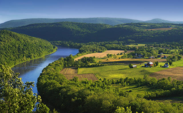 This landscape showing farming on lower, flatter areas contrasting with forested hills is typical of what the glaciated low Allegheny plateau looks like nowadays. Photo © Nicholas A. Tonelli, CC BY 2.0.
Plant Lists & In-Region Search
We do not yet have data to generate plant lists for a region as fine-tuned as this one. However you can move up to the broader Northern Allegheny Plateau and generate lists for that region: native plants or all plants. Or search that region's plants here:
↑References
1. Bryce, S.A., Griffith, G.E., Omernik, J.M., Edinger, G., Indrick, S., Vargas, O., and Carlson, D. "Ecoregions of New York (Poster)", U.S. Geological Survey (2010) Web.
2. Woods, A.J, Omernik, J.M., Brown, D.D. "Level III and IV Ecoregions of Delaware, Maryland, Pennsylvania, Virginia, and West Virginia", U.S. Environmental Protection Agency: National Health and Environmental Effects Research Laboratory, Corvallis, OR (1999) Web.