Home » Regions » North America » Eastern Temperate Forests » Ozark, Oauchita-Appalachian Forests » Blue Ridge » New River Plateau
New River Plateau
Last updated: July 25th, 2020
↑About the New River Plateau
The New River Plateau, referred to in some documents as the Interior Plateau of the Blue Ridge (not to be confused with the Interior Plateau of the central U.S., much farther west), is a high, hilly plateau nestled between higher-elevation ridges of the Blue Ridge mountains. It extends northeast-southwest, more east-west than north-south, and is located mostly in western Virginia but extends significantly into North Carolina as well. The region is named for the New River, which begins in this region and winds northeast, eventually leaving it to the north to flow into the Ohio river much farther northwest.This region is a high, hilly plateau with scattered isolated knobs and ridges. Elevations are mostly between 2,500-3,500 feet, with crest and peak elevations reaching 4,500 feet (1,372 m). Local relief is relatively low, 200 feet in most places. This region's topography is heterogeneous: flatter in some places, with gently rolling hills, and with steeper gorges and more sharply-dissected terrain in other places. The bedrock is metamorphic, including quartzite, graywacke, and conglomerate, and there are also outcroppings of gneiss and schist. Soils are variable, based on underlying rock type, but tend to be rocky and shallow.
This region was originally almost entirely forested. Much of this region was Appalachian oak forest, with northern red oak (Quercus rubra) and white oak (Quercus alba) dominant among numerous other oaks. Moister, cooler sites supported a more northern hardwood or hemlock-northern hardwood forest with American beech (Fagus grandifolia), yellow birch (Betula alleghaniensis), eastern hemlock (Tsuga canadensis), and tuliptree (Liriodendron tulipifera), and drier sites featured Oak-Hickory-Pine forest with hickories, longleaf pine (Pinus palustris), shortleaf pine (Pinus echinata), loblolly pine (Pinus taeda), white oak, and post oak (Quercus stellata). Like most of the Blue Ridge, American chestnut (Castanea dentata) was once an important component of the forests here.
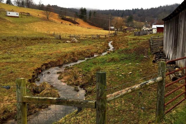
Land use here is mixed; because of the flatter terrain, this region has more agriculture and residential development than most of the Blue Ridge. There is pastureland, orchards, cropland, livestock and dairy farms, and Christmas tree farms. Agriculture is concentrated on the flatter sites; the more rugged terrain is mostly forested. As such, the forests here are mostly in large, unbroken tracts interspersed with large areas of cleared land.
To the northwest lies a narrow ridge of the Southern Sedimentary Ridges, which reaches significantly higher elevations and is much more rugged relative to this region. To the southeast and also surrounding this region to the south and west of the southern end, are the Southern Crystalline Ridges and Mountains, but this border consists of a plateau escarpment, as along the length of this region, those mountains are all at lower elevations than this plateau. Along most of this region, the border is abrupt and well-defined, but in the southernmost parts, the border is indistinct and the transition between these two regions is more gradual and ill-defined. In the far southwest of this region there is also a small border to the west with the Amphibolite Mountains.
 This photo taken in Independence, Virginia, shows a landscape typical of the New River Plateau, with pastureland on the lower, flatter terain, and forest on the steeper uplands. The soil is visibly rocky and shallow and the terrain is irregularly hilly. Photo © Joe Haupt, CC BY-SA 2.0, Source.
Plant Lists & In-Region Search
We do not yet have data to generate plant lists for a region as fine-tuned as this one. However you can move up to the broader Blue Ridge and generate lists for that region: native plants or all plants. Or search that region's plants here:
↑References
1. Woods, A.J, Omernik, J.M., Brown, D.D. "Level III and IV Ecoregions of Delaware, Maryland, Pennsylvania, Virginia, and West Virginia", U.S. Environmental Protection Agency: National Health and Environmental Effects Research Laboratory, Corvallis, OR (1999) Web.
2. Comstock, J.A.; Griffith, G.E.; Omernik, J.M. "Ecoregions of North Carolina: Regional Descriptions", (2002) Web.


