
Home » Regions » North America » Eastern Temperate Forests » Ozark, Oauchita-Appalachian Forests » Blue Ridge » Southern Crystalline Ridges and Mountains
Southern Crystalline Ridges and Mountains
Last updated: July 21st, 2020
↑About the Southern Crystalline Ridges and Mountains
The Southern Crystalline Ridges and Mountains, also referred to as the Southern Igneous Ridges and Mountains are a major component of the Blue Ridge mountains of the Appalachians. This irregularly-shaped region extends from southern Virginia through North Carolina just into South Carolina and Georgia, but the bulk of the region is located within North Carolina. The northernmost portion in Virginia is thin and scattered.This region consists of ridges and mountains separated by high gaps. Slopes are steep and mountain flanks are well-dissected. The crests and peaks reach up to 2,600-5,728 feet, with local relief ranging from 1,150-1,500 feet, some of the most rugged terrain in the Appalachians. The bedrock here is mostly coarse-grained metamorphic rocks mostly gneiss and schist, with some mafic and ultramafic (rich in iron and magnesium and low in silicate) igneous rock. Soils on metamorphic rocks tend to be well-drained, acidic loams, whereas soils derived from mafic and ultramafic rocks tend to be alkaline.
The climate here is cool and has very high precpitation, especially in the south and at the higher altitudes, with annual precipitation averaging over 90 inches annually in places. Although well inland from the ocean, this region is classified in the Koppen system as having an "Oceanic" climate, due to its cool, moderate temperatures and high rainfall. In many respects the climate here is similar to that in southern New England, and the combination of climate and rocky soils lead to numerous similarities in the natural vegetation.
Original vegetation was probably Appalachian oak forest at lower elevations, with a mix of oaks, as well as hickory, pine, tuliptree (Liriodendron tulipifera), birch, and maple. Appalachian cove forests were found on small, sheltered valleys, and higher elevations featuring northern hardwood forest of sugar maple (Acer saccharum), yellow birch (Betula alleghaniensis), American beech (Fagus grandifolia), and hemlock, including eastern hemlock (Tsuga canadensis) on more sheltered sites and carolina hemlock (Tsuga caroliniana) on rockier sites at highest elevations. American chestnut (Castanea dentata) was formerly dominant. The southernmost portions of this region also featured some mixed mesophytic forest, with buckeye, American basswood (Tilia americana), tuliptree, and American beech. The plants here include many species that are normally only found farther north.
Higher elevations and more rugged terrain are almost entirely forested, but at lower elevations, especially on flatter sites, there is a small amount of pastureland, apple orchards, cropland, and in the north, Christmas tree farms, usually growing Fraser fir (Abies fraseri), which occurs naturally only at the highest elevations in these mountains. Forests here are mostly second-growth forests, with old growth mostly limited to sites with steep slopes or other reasons for being commercially unviable. American chestnut has mostly been eliminated due to the blight, and replaced with chestnut oak (Quercus montana) and other oaks, but forest composition is otherwise presumed to be similar to its original state. Although a large portion of this region consists of protected public lands, there is still some logging in public lands. This area is mainly utilized for tourism and recreation, hunting, and forest products. Even in protected areas, global warming is threatening many species, pushing them to higher elevations as the climate warms, causing many local populations to become reduced or eliminated.
Within the Blue Ridge, this region shares irregular borders with many different regions, including the Southern Metasedimentary Mountains, the Broad Basins, which are interspersed throughout the Blue Ridge, the High Mountains encompassing the highest peaks, and the Southern Sedimentary Ridges. To the southeast, this region borders the Eastern Blue Ridge Foothills, and past that, the Northern Inner Piedmont over most of its length, and the Southern Inner Piedmont at the southern end.
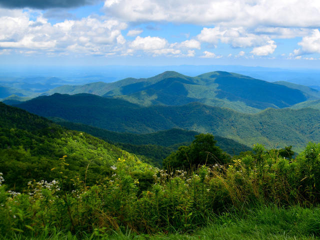 This photo, taken from the Green Knob Overlook on the Blue Ridge Parkway, shows the typical landscape of the Southern Crystalline Ridges and Mountains of the Blue Ridge mountains, with rugged, forested mountains with well-dissected flanks. Crop of a photo © Ron Cogswell, CC BY 2.0, Source.
Plant Lists & In-Region Search
We do not yet have data to generate plant lists for a region as fine-tuned as this one. However you can move up to the broader Blue Ridge and generate lists for that region: native plants or all plants. Or search that region's plants here:
↑References
1. Woods, A.J, Omernik, J.M., Brown, D.D. "Level III and IV Ecoregions of Delaware, Maryland, Pennsylvania, Virginia, and West Virginia", U.S. Environmental Protection Agency: National Health and Environmental Effects Research Laboratory, Corvallis, OR (1999) Web.
2. Griffith, G.E.; Omernik, J.M.; and Azevedo, S.H. "Ecoregions of Tennessee (Poster)", U.S. Geological Survey, Reston, VA (1998) Web.
3. Comstock, J.A.; Griffith, G.E.; Omernik, J.M. "Ecoregions of North Carolina: Regional Descriptions", (2002) Web.
4. Griffith, G.E., Omernik, J.M., Comstock, J.A., Lawrence, S., Martin, G., Goddard, A., Hulcher, V.J., and Foster, T. "Ecoregions of Alabama and Georgia (color poster with map, descriptive text, summary tables, and photographs)", U.S. Geological Survey, Reston, VA (2001) Web.