
Home » Regions » North America » Eastern Temperate Forests » Southeastern USA Plains » Piedmont » Northern Inner Piedmont
Northern Inner Piedmont
Last updated: March 19th, 2021
↑About the Northern Inner Piedmont
The Northern Inner Piedmont is the northeasternmost region of the Piedmont (treated as distinct from the Northern Piedmont), extending across about half the length of the Piedmont, along its northwesternmost border, but shaped irregularly and interspersed with other regions. It is mostly located in Virginia, with a significant portion in North Carolina.This region is a dissected upland with hills, irregular plains, and some isolated ridges, mountains, and monadnocks, which are isolated hills made of exposed bedrock, conspicuously standing out from their surroundings. Elevations typically range from 200 to 1,000 feet with relief of 200-1,000 feet, but monadnocks reach up to 2,000 feet with relief as high as 1,100 feet. The geology of this region is complex and varied: the underlying bedrock consists of heavily deformed and weathered gneiss, schist, and melange, with intrusions of plutons, igneous rock that crystalized slowly and thus tend to be hard and erosion-resistant. On top of this are clay-rich weathering products such as saprolite.
Soils in this region tend to be clayey and acidic, but there can be considerable variation due to differential weathering of the various substrates. Streambottoms are more silty and sandy than upstream in the Appalachians.
Originally, this area was probably covered in Oak-Hickory-Pine forest, dominated by hickory, shortleaf pine (Pinus echinata), loblolly pine (Pinus taeda), white oak (Quercus alba), and post oak (Quercus stellata). Nowadays, the forests are more pine-dominated, mainly loblolly and shortleaf pines. Especially in the south of this region, there is more Virginia pine (Pinus virginiana), and less shortleaf pine, than in areas to the southeast. Chestnut oak (Quercus montana) is common on more level uplands. In general, there are more plant species here that are also found in the mountains to the northwest, than areas to the southeast, and the flora here can be seen as transitional between the Appalachians and the rest of the Piedmont.
There is significant agriculture here, including production of livestock, dairy, and poultry, as well as corn, small grain, rye, tobacco, and hay. There is also significant forestry here; this region is considered higher-quality for timber production than the neighboring outer piedmont. This area is not densely populated; larger cities here include Lynchburg, and Danville, VA, and Hickory, NC, followed by the rather small cities of Martinsville, VA and Mt. Airy, NC. The far northern end of this region reaches the edge of the Washington, DC metro area and contains some of its suburbs.
To the southeast, this region is bordered by the Northern Outer Piedmont in the north and the Southern Outer Piedmont in the south. This border is ill-defined and subjective, and represents a gradual transition between different soil temperature regimes, different forest types, and changes in the aquatic ecosystems. In between these regions, however, there is a small border with the Carolina Slate Belt, which has more well-defined borders based on geoloogy. Also with well-defined borders, some of the Triassic Basins border or are contained within this region; these basins are also interspersed throughout neighboring regions of the Piedmont.
To the northwest this region is bordered by the Blue Ridge of the Appalachians. The first region, intruding into this one, is the Eastern Blue Ridge Foothills. Along the northwestern edge though there is a direct border with the Southern Crystalline Ridges and Mountains. Farther north, the northwestern border is with the Northern Igneous Ridges. The northernmost boundary of this region is a more gradual transition with the Piedmont Uplands of the Northern Piedmont. That area is geologically similar, and is distinguished by its cooler climate. This region also surrounds an isolated mountain range, the Sauratown Mountains, which is geologically part of the Blue Ridge but separated from it geographically.
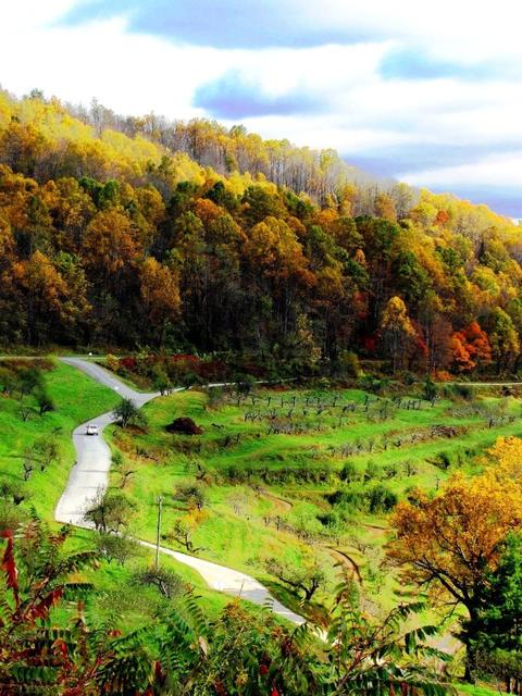 The Northern Inner Piedmont has both extensive agriculture and wild forest, and much of it is quite hilly like in this photo near Laurel Hill, Lincoln County, NC. Photo © moonjazz (Flickr), Public Domain, Source.
Plant Lists & In-Region Search
We do not yet have data to generate plant lists for a region as fine-tuned as this one. However you can move up to the broader Piedmont and generate lists for that region: native plants or all plants. Or search that region's plants here:
↑References
1. Woods, A.J, Omernik, J.M., Brown, D.D. "Level III and IV Ecoregions of Delaware, Maryland, Pennsylvania, Virginia, and West Virginia", U.S. Environmental Protection Agency: National Health and Environmental Effects Research Laboratory, Corvallis, OR (1999) Web.
2. Griffith, G.E., Omernik, J.M., Comstock, J.A., Lawrence, S., Martin, G., Goddard, A., Hulcher, V.J., and Foster, T. "Ecoregions of Alabama and Georgia (color poster with map, descriptive text, summary tables, and photographs)", U.S. Geological Survey, Reston, VA (2001) Web.
3. Comstock, J.A.; Griffith, G.E.; Omernik, J.M. "Ecoregions of North Carolina: Regional Descriptions", (2002) Web.