
Home » Regions » North America » Great Plains » West-Central Semi-Arid Prairies » Northwestern Glaciated Plains
Northwestern Glaciated Plains
Last updated: November 25th, 2025
To check where a specific point lies, you can look it up in our Ecoregion Locator.
↑Map Legend & Subregion List
This list will help you navigate the regions in case you have problems with viewing or clicking the interactive map above.
† Status: ✓ = Complete ○ = Needs Image … = Incomplete ∅ = Stub Only
‡ This code refers to the US EPA's Level 4 ecoregion codes for the continental U.S., see here.
↑Progress
Partially Complete | With Images | Complete w/ Images |
Get involved! You can help our ecoregion articles progress faster. Help us find photos of these regions. Contact us if you have any additions or corrections to any of these articles. You can also donate to support our ongoing work.
↑About the Northwestern Glaciated Plains
The Northwestern Glaciated Plains are a region located mostly in southeastern Alberta, southwestern Saskatchewan, and northern Montana, but also with a narrower section extending southeast through North Dakota, and south through South Dakota, barely reaching into Nebraska. Although the region is contiguous, there are several holes in it which reflect areas of higher elevation: the Cypress Uplands in the north, and a few isolated parts of the Middle Rockies farther south.The region has a mid-latitude steppe climate, also called a cold semi-arid climate. The climate is continental, characterized by sudden and sometimes extreme changes in temperature and/or moisture, driven by movement of large air masses across the flat regions of the continent. Precipitation is seasonal, with dry winters and a wet season peaking some time between May and June. The peak of precipitation tends to precede the peak of temperatures, with late summer being hotter and somewhat drier. Rainfall decreases to the west, but winter lows also are warmer, reflecting a greater distance from the interior of the continent where polar air masses tend to reach farther south during cold spells. Although the region slopes upward to the west, and higher elevations tend to be colder and wetter, the east-west effect overcomes the effect of elevation, and this region becomes warmer and drier moving westward. This effect explains the region's unusual shape, extending much farther north at its western end.
The terrain here is transitional between the flatter regions to the northeast, and the more rugged regions to the southwest. The terrain is irregular, with gentle, rolling hills interspersed with some more abrupt, steeper landforms, isolated in places and concentrated in regions of badlands in others. This region was almost entirely glaciated, and most of the landscape is glacial in origin. Features include moraine, outwash, and sediments that accumulated under glacial lakes. Glaciers disrupted drainage patterns, creating numerous small basins, which in places (the highest concentration in North Dakota) are filled with numerous lakes, ponds, and wetlands; shallower depressions dry up seasonally. The soils are mostly mollisols, rich soils that formed under prairies, with significant areas of entisols, less-developed soils where the original material is close to the surface. The combination of cold temperatures and dry conditions tends to hinder soil development. Entisols tend to be found on sites where erosion exposes lower layers of soil, and/or steeper terrain prevents accumulation of organic matter.
The vegetation cover here was transitional between mixed grass prairie and shortgrass prairie in the northwest. The dominant grasses were green needlegrass (Nassella viridula), blue grama (Bouteloua gracilis), western wheatgrass (Pascopyrum smithii), and slender wheatgrass (Elymus trachycaulus), and there were a number of herbaceous plants and shrubs, including some sagebrush (Artemisia sp.) Plains pricklypear (Opuntia polyacantha) was found on the driest sites, with some brittle pricklypear (Opuntia fragilis) and Missouri foxtail cactus (Escobaria missouriensis) in the south of the region. On the moistest sites, shaded valley slopes and river terraces, there were small areas with scrubby growth of aspen, willow, eastern cottonwood (Populus deltoides), and box elder (Acer negundo). Sites with high salt content in the soil, usually in endorheic basins that water drains into but does not flow out of, supported Nuttall's alkaligrass (Puccinellia nuttalliana), foxtail barley (Hordeum jubatum), greasewood (Sarcobatus vermiculatus), and other plants.
Very few areas of natural vegetation cover remain, and although the population here is sparse, most of the land is actively utilized. The dominant use is as rangeland for cattle grazing. There is some cropland, producing spring wheat and other cereal grains, as well as oilseed crops. Typically, cropland here is left fallow every other year as the soils and climate are not able to sustain continuous cultivation. There is significant waterfowl hunting as well. A number of rivers have been dammed, creating large reservoirs which are used both for water supply and recreation. The water from these reservoirs is primarily used for irrigation. One reservoir, the Val Marie Reservoir, has a Migratory Bird Sanctuary, as it is the only large permanent body of water in the region around it, and supports a large number of waterfowl.
There are a number of medium-sized cities, spaced far enough apart that the total population density through the region is low. Most of the population centers are located on the Canadian side of the border. These cities include Lethbridge, AB, Medicine Hat, AB, Saskatoon, SK, and Regina, SK. The largest city on the US side is Bismarck, ND. The larger population center of Calgary, AB is located outside this region to the west. There is a relatively dense network of roads through this region, especially relative to the low population density. As with much of the Midwest, the land is divided into a 1-mile square grid, although not every edge of the grid has a road on it. In much of the region, there are roads spaced somewhere between 1 to 5 miles apart, mostly located along the grid. There are some Native American reservations here, including Fort Belknap Reservation and Fort Peck Reservation in Montana. There is some protected public land here as well, including Grasslands National Park in Saskatchewan, Twin River Heritage Rangeland Natural Area in Alberta, and Chase Lake National Wildlife Refuge in North Dakota. Much of the lakes and wetlands in North Dakota are actively managed for waterfowl production for hunting, as part of the Waterfowl Production Areas of the US National Wildlife Refuge System.
To the southwest, at the limit of glaciation, this region is bordered by the Northwestern Great Plains, which tends to be more rugged, irregular, and drier. To the north and east, this region borders the Northern Glaciated Plains, which tends to be flatter, moister, and have a greater density of cropland. At the far southeastern end, this region is bordered to the south by the Nebraska Sand Hills. The north of this region completely surrounds the Cypress Uplands, a higher elevation area that is colder, wetter, and supports forests. Farther south, there are also a few isolated regions of the Middle Rockies surrounded by this region, specifically the Scattered Eastern Igneous-Core Mountains. The westernmost portion of this region also borders the Canadian Rockies to the west, a mountainous region that is much steeper and higher in elevations, and has higher rainfall that supports forests.
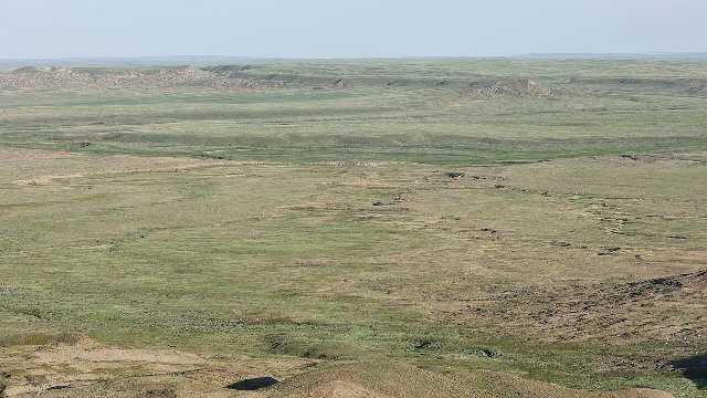 This aerial photo of Grasslands National Park shows one of the few intact natural grasslands of the Northwestern Glaciated Plains. Located relatively centrally in this region, this park preserves what is closest to the original vegetation of the region. Photo © Simon Pierre Barrette, Cephas on Wikipedia, CC BY-SA 4.0, Source.
Plant Lists & In-Region Search
List Native Plants - List All Plants
Warning! This region extends outside the lower 48 US. We have only completed range maps for all plants in the lower 48 US; these lists and searches may thus have omissions for species which only occur in the portion of this region outside the lower 48 US.