Home » Regions » North America » Eastern Temperate Forests » Mixed Wood Plains » Acadian Plains and Hills » Penobscot Lowlands
Penobscot Lowlands
Last updated: July 28th, 2020
Page contents
↑About the Penobscot Lowlands
The Penobscot Lowlands are a region in Maine, slightly inland from the coast, that is significantly lower and flatter than their surroundings. This region is characterized by soils formed on deep, fine sediments, and abundant flat, swampy areas.This region varies from flat to gently rolling terrain, with a few low hills. There are numerous wetlands, including both river floodplains, fens, and bogs. The
region is mostly covered with silt and clay of marine origin. There is some coarser sand and gravel, mostly along the Penobscot river, and there is some glacial till, although during the recent glacial period much of this region was underwater. The underlying metasedimentary bedrock, is deeply buried in most places. The climate here is moderate, among humid continental climates, due to the low elevation and proximity to the ocean.
This region is high in plant biodiversity. Originally this region was mostly covered with mixed coniferous-hardwood forest, with some open wetlands. Most of the area supported spruce-fir-northern hardwood forest, and there was some white pine-northern hardwood forest. Wooded bogs supported northern white-cedar (Thuja occidentalis), black spruce (Picea mariana), and red spruce (Picea rubens). Wet meadows and fens were more open, with grasses and sedges and there were also shrub thickets of willow and alder, and shrub heaths with rhodora (Rhododendron canadense), leatherleaf (Chamaedaphne calyculata), and bog Labrador tea (Ledum groenlandicum). Floodplains of streams and rivers supported forests of red maple (Acer rubrum), silver maple (Acer saccharinum), northern red oak (Quercus rubra), bur oak (Quercus macrocarpa), and black ash (Fraxinus nigra).
This area remains mostly forested. Northern hardwood and spruce-northern hardwood forest are the most common forest types, and there are also many second-growth eastern hemlock (Tsuga canadensis) forests, which also feature sugar maple (Acer saccharum), large-tooth aspen (Populus grandidentata), paper birch (Betula papyrifera), and eastern white pine (Pinus strobus). Low ridges support some areas of red pine (Pinus resinosa). There is some forestry, as well as hunting and fishing. There is some protected land, including Sunkhaze Meadows National Wildlife Refuge, as well as a small amount of Native American lands belonging to the Penobscot people, after whom this region is named. Overall, this region is more sparsely populated and less developed than areas to the west and south. Bangor is the largest city here. There is a small amount of urbanization and low-density suburban-rural development around the corridor from Bangor to Old Town, and some sparse agriculture in this area as well.
This region is bordered to the southwest by the Central Maine Embayment, which has a higher population density as well as more agriculture. To the east and southeast lie the Eastern Maine-Southern New Brunswick Plains. This region is bordered to the northwest by the more rugged, upland Central Foothills.
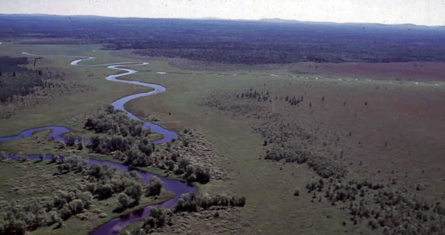
 This aerial photo shows Sunkhaze Meadows National Wildlife Refuge in Maine, a large area of protected wetlands in the Penobscot Lowlands; the broader ecoregion also contains numerous flat areas on drier ground. Photo © U.S. Fish and Wildlife Service, Public Domain, Source.
Plant Lists & In-Region Search
We do not yet have data to generate plant lists for a region as fine-tuned as this one. However you can move up to the broader Acadian Plains and Hills and generate lists for that region: native plants or all plants. Or search that region's plants here:
↑References
1. Griffith, G.E., Omernik, J.M., Bryce, S.A., Royte, J., Hoar, W.D., Homer, J.W., Keirstead, D., Metzler, K.J., and Hellyer, G. "Ecoregions of New England (Poster)", U.S. Geological Survey (2009) Web.


