
Home » Regions » North America » Eastern Temperate Forests » Mixed Wood Plains » Acadian Plains and Hills » Eastern Maine-Southern New Brunswick Plains
Eastern Maine-Southern New Brunswick Plains
Last updated: July 23rd, 2020
Page contents
↑About the Eastern Maine-Southern New Brunswick Plains
The Eastern Maine-Southern New Brunswick Plains is a region in eastern Maine and western New Brunswick, located slightly inland from the coast.The terrain here is diverse, ranging from flat through rolling plains to hills of varying sizes; local relief ranges from 50-1,000 feet and elevations range from 20 to 1,510 feet. There are numerous glacial features, including eskers, kames, and drumlins, as well as lakes, ponds, bogs, and other wetlands of glacial origin. Flatter regions are mostly covered in loamy to sandy glacial till. Glacial till is thinner on hills, and higher hills often have bedrock outcroppings. The bedrock is a diverse mix of metasedimentary rocks and some granite and other igneous rocks. These rocks are varied in their erodibility as well as their calcium content and the texture of soils they produce.
This region has a high density of peatlands. Lakes here tend to be shallow, low in nutrients, and acidic. However, some wetlands located on calcareous substrates are more alkaline. The climate is humid and continental, and tends to be milder than areas to the northwest, but less moderate than the coastal areas to the south.
This area originally had a diverse mix of forest types, but with conifers more dominant on average than hardwoods. Spruce-fir-broom moss forest was dominated by red spruce (Picea rubens), with some balsam fir (Abies balsamea), and occasional eastern hemlock (Tsuga canadensis), with an understory of moss, lichen, and liverwort. There was also northern hardwood forest, dominated by sugar maple (Acer saccharum), American beech (Fagus grandifolia), and yellow birch (Betula alleghaniensis), with some hemlock, red maple (Acer rubrum), and paper birch (Betula papyrifera). There was also spruce-fir-cinnamon fern forest, with red and black spruce (Picea mariana), red maple, and balsam fir, and cinnamon fern (Osmunda cinnamomea) in the understory. White pine-mixed conifer forests featured eastern white pine (Pinus strobus), red spruce, red pine, hemlock, and red maple. Spruce-northern hardwood forests featured red spruce, yellow birch, balsam fir, and some white pine. There were also swamps dominated by northern white-cedar (Thuja occidentalis) and black spruce, with a variety of herbs and shrubs.
This area is mostly sparsely populated, with only small towns, and is almost entirely forested except for areas that have been recently cleared in forestry operations. A significant portion of the land here is utilized for forestry. There are some native American lands here, belonging to the Passamaquoddy and Penobscot peoples. There is also some fishing, hunting, and recreation here. There is also some public protected land, including Moosehorn National Wildlife Refuge, and some private protected land, including Downeast Lakes Community Forest.
This region is bordered to the south by the Downeast Coast, which has a more ocean-moderated climate and is more populated and developed. To the west, this region borders many different regions. In the south, it is bordered by the Central Maine Embayment, an area that is both more populous and more utilized for agriculture. North of that, the western border is with the Penobscot Lowlands, a low, flat area with fine-textured soils. Farther north, the border to the west is with the more rugged Central Foothills. The northernmost parts of this region are bordered to the northwest by the Aroostook Hills and to the northeast by the Aroostook Lowlands.
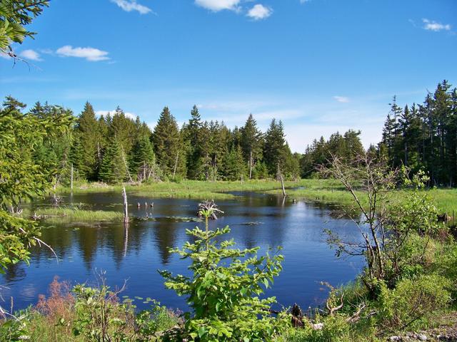 This photo from Moosehorn National Wildlife Refuge shows a pond and bordering wetlands, with coniferous forest in the background, a common sight throughout this region. Photo © U.S. Fish and Wildlife Service, Public Domain, Source.
Plant Lists & In-Region Search
We do not yet have data to generate plant lists for a region as fine-tuned as this one. However you can move up to the broader Acadian Plains and Hills and generate lists for that region: native plants or all plants. Or search that region's plants here:
↑References
1. Griffith, G.E., Omernik, J.M., Bryce, S.A., Royte, J., Hoar, W.D., Homer, J.W., Keirstead, D., Metzler, K.J., and Hellyer, G. "Ecoregions of New England (Poster)", U.S. Geological Survey (2009) Web.