Home » Regions » North America » Tundra » Alaska Tundra » Seward Peninsula
Seward Peninsula
Last updated: November 6th, 2024
Page contents
↑About the Seward Peninsula
The Seward Peninsula is the middle of three major peninsulas on the West Coast of Alaska, and this ecoregion covers most of the peninsula, excepting the northernpost part which is low and flat, and considered part of the Subarctic Coastal Plain. The region also includes the upland parts of St. Lawrence Island and a few small, rugged islands such as King Island. Alaska was once connected to Asia via the Bering Land Bridge, and this peninsula still has the point on land closest to Asia. Two small islands, the Diomede Islands, belonging to Russia and not considered part of North America for political reasons, lie in the Bering Strait between this region and the Asian mainland.The climate here is subarctic. Although this peninsula is surrounded on three sides by water, it is spanned by ice for much of the year, reducing any moderating effect the water might have on the climate, excepting in summer. Winters are long and harsh, and summers are short and cool. Summers are cooler and foggier along the coast. The eastern portion of the region has more continental climate influence. There is continuous permafrost throughout most of the region, but the permafrost is thin in places. There are numerous ice-related features, including pingos (ice-cored hills), and patterned ground including ice-wedged polygons and stone stripes.
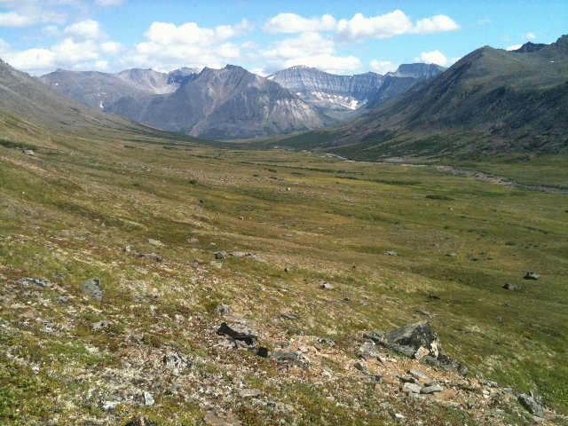
The terrain here is unusually varied and diverse. There are some ranges of rugged mountains, and larger areas of broader hills, interspersed with broad bottomlands. There are bottomlands both along the coast, and inland, and there are also areas of coastline where the rugged terrain extends right to the water's edge, with steep cliffs in places. The shape of the terrain has a mix of valleys cut by glaciers and by water. Glacier-formed areas feature broad-bottomed, steep-walled, U-shaped valleys that open into poorly-drained bottomlands, whereas water-formed areas feature a well-developed drainage networks of streams flowing through V-shaped valleys. In some areas these water-formed features then drain into glacial valleys, leading to unusual combinations of terrain absent from most regions. The geology is also diverse, with a mix of sedimentary, metamorphic, and volcanic rocks, but the climate is so cold that the diverse geology has little influence on surface soils. Permafrost is continuous throughout, but thin in places. Soils tend to be wet, shallow, and formed mostly on organic matter.
This region is unusually high in plant diversity relative to its harsh climate and sparse vegetation cover. Cover consists mostly of tundra and low scrub. Low elevations mostly feature tussock-forming sedges, whereas higher elevations have alpine tundra with mountain avens (Dryas sp.) and lichens. The better-drained sites at low elevations support dwarf growth of ericaceous shrubs, willow, and birch. There are a large number of species that are rare, but present in this region, and they include some predominately-Asian species as well as some from coastal areas farther south and some from farther east in interior Alaska. The diversity of topography also creates more different ecological niches here than in more uniform regions. Shrub cover has been increasing here as the climate warms.
This region is sparsely populated, but has a large portion of Native Americans. The largest city is Nome, with over 3,500 people. The population is limited to the coast, and people usually only travel to the inland of this region in summer. The economy mostly revolves around subsistence and recreational hunting and fishing; there is also some gold mining.
This region is bordered to the north by the Subarctic Coastal Plains, a region that is flat, poorly-drained, covered in numerous small ponds, and lower in plant diversity. This same region also picks up farther south along the coast, but does not border this region to the south. To the southeast, and inland to the east, this region is bordered by the Interior Forested Lowlands and Uplands, a slightly warmer region with lower, but still varied topography, that has some areas of richer plant growth and supports forests in places.
 This photo shows the Kigluaik Mountains, the most rugged portion of the Seward Peninsula, in the distance, with a glacial valley in the foreground. Note the broad valleys and the steep-walled upper slopes, characteristic of glacial terrain. The Seward Peninsula has a mix of such terrain with more water-carved V-shaped valleys in other places. Vegetation cover is sparse, owing to the harsh climate and permafrost. Photo © Bureau of Land Management, Alaska, Public Domain, Source.

