Home » Regions » North America » Tundra » Alaska Tundra » Subarctic Coastal Plains
Subarctic Coastal Plains
Last updated: November 4th, 2024
Page contents
↑About the Subarctic Coastal Plains
The Subarctic Coastal Plains are a coastal region in Alaska, along the Bering Sea, consisting of several discontiguous pieces. This region encompasses the flat, coastal areas of western Alaska that lie northwest of the Ahklun and Kilbuck Mountains and south of the Brooks Range. Most of the region is on the mainland, but it also includes some islands, including all of Nunivak island, the flatter part of St. Lawrence Island, and a number of smaller islands with flat topography. The region is interrupted by some more rugged areas of higher elevation, particularly on the Seward Peninsula.The climate is subarctic with a mix of marine and continental influences, with continental influence increasing to the east. Temperatures and precipitation increase fairly uniformly moving southward through this region. In a typical year, the whole coastline freezes in winter, with the ice extending well offshore, and the extent of Arctic sea ice extending quite a ways south past this region. The ice minimizes the moderating effect of the ocean on this region during winter, such that the ocean cools the summer temperatures more than it warms winter temperatures. Global warming however has been leading to record-low extents of ice, and this situation may change at some point in the near future: if the sea ice stops extending along this region, its climate will become significantly warmer in winter in the ice-free areas. Inland portions of this region have continuous permafrost, but it is thin in most places.
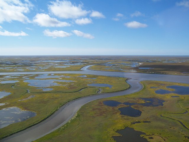
The terrain is flat and the drainage is poor both due to the level terrain and abundance of permafrost. There are a few low hills of volcanic origin. Streams are slow-moving and heavily meandering, and there is an abundance of thaw ponds and sinks and some larger lakes as well. Rivers tend to form large deltas where they flow into the ocean. The density of ponds here is much higher than the otherwise similar but warmer Bristol Bay-Nushagak Lowlands farther southeast along the coast.
This region is mostly devoid of trees, although there are some woody plants, mostly in their dwarf forms. Coastal areas feature brackish marshes and wet meadows. Inland, insulated from salt water and tidal influence, there is scrubby growth of ericaceous shrubs, tussock-forming sedges, and bogs filled with sedges and mosses. The best-drained sites along rivers and on sloped terrain support thickets of willow, and in the south of this region there are a few sites supporting white and black spruce. Overall, this region tends to be lower in plant diversity than areas farther north, east, and south. It is significantly colder than areas to the south, and plant growth here is also limited by the permafrost, poor drainage, and general uniformity of the terrain which creates fewer ecological niches than areas with more varied topography.
Most of this region is sparsely populated, with a mix of permanent and seasonal settlements, mostly along the coast or the major rivers. There is both subsistence and recreational fishing and hunting, but not as much commercial fishing as areas farther south. There is some gold and silver mining. The city of Bethel, home to over 6,000 people, is located here. After this, the next largest settlements, are Alakanuk and St. Mary's, both with not much over 500 people. The population here is predominately Native American.
This region is bordered to the southeast by the Ahklun and Kilbuck Mountains, a more rugged area reaching to higher elevations. Although the portion of that region that borders this one is relatively more barren, that region also supports lusher forests farther south and east. Inland to the east, this region borders the Alaska Boreal Interior; most of it borders the relatively hillier, more upland Interior Forested Lowlands and Uplands but there are a few areas along the larger rivers where it instead borders the Interior Bottomlands. In the north-central portion of this region, it is interrupted by and interspersed with the Seward Peninsula ecoregion, which is more rugged and higher-elevation.
 This photo of Yukon Delta National Wildlife Refuge shows the outermost portions of the Subarctic Coastal Plain, where the terrain is almost entirely flat, the landscape is dotted with nearly endless ponds, and there are no trees at all. Photo © U.S. Fish & Wildlife Service, Alaska Region, Public Domain, Source.

