
Home » Regions » North America » Northwestern Forested Mountains » Boreal Cordillera » Copper Plateau
Copper Plateau
Last updated: June 19th, 2024
Page contents
↑About the Copper Plateau
The Copper Plateau is a flat region in Southcentral Alaska located between The Alaska Range, Wrangell Mountains, and Pacific Coastal Mountains. This region is characterized by poor drainage and severely cold winters.The climate is dry, subarctic, and continental, and is relatively uniform throughout. Cold air drainage from the surrounding mountains leads this region to be colder than it would be based on its latitude alone. Winters are particularly harsh, with five months featuring mean minimums of -32°F (-25°C) or below and record lows of -46°F (-50°C) or below. Rain shadow leads this region to be much drier than areas of similar elevation near the coast, and slightly drier than areas north of the Alaska Range, but not as dry as areas east of the Wrangell and St. Elias Mountains.
Most of this region is nearly completely level, although there are a few areas of gently rolling hills, and also some steep slopes down into the lower-level channels along the Copper River and its tributaries. This region was covered in a large glacial lake, Lake Ahtna, around 58,000 years ago, with water filling to over 3,000 feet above sea level, and as such there are numerous features of lake origin throughout, and most of the region is formed on lake sediments, which are visible in areas where rivers have cut through them to deeper levels. This lake formed when glaciers blocked the exit of water where the Copper River now flows through the coastal mountains into the Pacific. The remnants of the lake exist as numerous smaller lakes throughout the region. The largest such lake is Lake Louise, which is unusual in that it has a large island in it, itself with several smaller lakes in it.
Surface soils here tend to be poorly-drained, with clay and silty loess near the surface, but highly variable material deeper down, including alluvium, glacial till, and lake deposits. Permafrost usually reaches to within 10 inches of the surface, solidly within the loess layer, so liquid water rarely reaches to better-drained materials beneath the surface. The combination of poorly-drained soil texture, extensive permafrost, and flat topography makes this one of the poorest-drained regions in Alaska.
Because of the low rainfall, most streams and rivers originate outside of this region, where they are fed in large part by snowmelt and glacial meltwater. As such, spring floods are common. There are also numerous thaw ponds, formed in summer by temporary melting of permafrost, leading to large areas of thermokarst.
This region is unusually low in plant diversity due to a combination of harsh conditions and being isolated from areas of higher biodiversity. Plants have been able to colonize this area primarily through two corridors: a narrow area where the Copper River cuts through the Pacific Coastal Mountains, connecting this region to the more biodiverse temperate rainforests along the Pacific Ocean, and an area in the northeast where the mountains open slightly to connect with interior Alaska and the Yukon. Two other such corridors are where the Susitna river comes near the northwest corner of this region, and in the southwest of this region, the Matanuska river, both of which flow west connecting with the more biodiverse, ocean-moderated Cook Inlet.
Black spruce (Picea mariana) is the dominant tree throughout, forming extensive forests that are, in most places, stunted and open, although that vary in lushness as a function of drainage and permafrost. Black cottonwood, willow, and alder are found along rivers and streams. The lushest forests tend to be located towards the south and east of this region, along the larger rivers, where a drainage network has developed and the terrain has sometimes been eroded into better-drained substrates.
There are a few small human settlements, mostly located along a few major corridors. Because this region is flat, it has a relatively well-developed road network relative to its isolated location and mountainous surroundings, with roads reaching from here west to Anchorage, north to interior Alaska, northeast, south to Valdez on the coast, and east to the small settlement McCarthy near the headwaters of the Copper River.
This region is surrounded on all sides by rugged mountains of volcanic origin, all of which are covered in glaciers and ice fields at high elevations. It is bordered to the south by the Pacific Coastal Mountains, which have a more ocean-moderated climate. To the east it surrounds the northwest end of the Wrangell and St. Elias Mountains, a similar region that is less ocean-moderated. The rest of the region, mostly to the north and west, is surrounded by the Alaska Range.
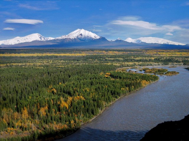 This photo shows the eastern end of the Copper Plateau, one of the better-drained portions of the region, with the Copper River in the foreground and the Wrangell Mountains in the distance. Although there are fewer lakes and slightly lusher forests here than in most of the region, the flat landscape abruptly bordered by dramatic mountains is typical. Photo © Wrangell-St. Elias National Park & Preserve, CC BY-SA 2.0, Source.