
Home » Regions » North America » Northwestern Forested Mountains » Boreal Cordillera
Boreal Cordillera
Last updated: November 7th, 2024
To check where a specific point lies, you can look it up in our Ecoregion Locator.
↑Map Legend & Subregion List
This list will help you navigate the regions in case you have problems with viewing or clicking the interactive map above.
| Name | † | Color on Map | CEC Code‡ |
| Interior Highlands and Klondike Plateau | ✓ | 6.1.1 | |
| Alaska Range | ✓ | 6.1.2 | |
| Copper Plateau | ✓ | 6.1.3 | |
| Wrangell and St. Elias Mountains | ✓ | 6.1.4 | |
| Watson Highlands | ✓ | 6.1.5 | |
| Yukon-Stikine Highlands/Boreal Mountains and Plateaus | ✓ | 6.1.6 |
† Status: ✓ = Complete ○ = Needs Image … = Incomplete ∅ = Stub Only
‡ This code refers to the CEC's Level 3 ecoregion codes for North America, see here.
↑Progress
Partially Complete | With Images | Complete w/ Images |
Get involved! You can help our ecoregion articles progress faster. Contact us if you have any additions or corrections to any of these articles. You can also donate to support our ongoing work.
↑About the Boreal Cordillera
The Boreal Cordillera is an assemblage of mountainous regions in northern British Columbia, southwestern Yukon, and Alaska. It is the northernmost portion of the Northwestern Forested Mountains, and it represents the northwesternmost mountains in North America capable of supporting forests at least somewhere on their slopes. It does not include the Brooks Range Tundra, mountains farther north and largely devoid of forest cover, and it is also separate from the Taiga Cordillera farther northeast, a region that has sparser forest cover.Terrain here varies from the highest, most rugged mountains in North America, to lower mountains and more hilly regions of dissected plateaus. Most of this area was recently glaciated, and many glaciers and ice fields still exist at higher elevations. However, many of the mountain peaks here have remained above the tops of the glaciers, and there are also broad portions of this region that have never been glaciated and thus have water-dissected terrain with narrow, V-shaped valleys. Glaciated areas have deep, U-shaped valleys with flatter bottoms and steep upper slopes. Some parts of the region have Karst topography, with extensive eroded limestone and caves.
Summers are short and winters long and cold throughout, but there are wildly different microclimates in different portions of this region, mediated both by altitude and by other factors including orographic lift and rain shadow, and influence of air masses moving from other regions including the Pacific Ocean, the Arctic, and the continent. Permafrost is discontinuous, existing at higher altitudes but being absent at lower altitudes. Rainfall is lowest in valleys and highest on western and west-facing mountain ranges, becoming lower on east-facing slopes and as one moves eastward overall.
Much of the precipitation here falls as snow, which becomes available to lower-altitude areas as it melts and flows downstream. In summer, humid air from the pacific can sometimes lead to violent storms. However, fire is less common here than in regions to the east.
Lower elevations are largely forested, with forests mostly consisting of conifers, fewer mixed forests, and only a few scattered areas where hardwoods are dominant. High elevations open to alpine meadows, tundra, and at the highest elevations, especially where there are large areas of high elevations, extensive ice fields and glaciers.
Most of this region is sparsely populated, but more populous than some of its northern neighbors. The city of Whitehorse, Yukon is the largest settlement and contains the bulk of this region's population. Mining, particularly of gold, but also of other minerals, is the dominant industry here. There is also some forestry, although less than in the flatter boreal forests farther to the east.
To the southwest lies the Marine West Coast Forest, where areas of similar elevation have a much milder, wetter climate influenced by the ocean. To the southeast, continuing along the rocky mountains, this region gradually transition into the Western Cordillera. To the northwest, as one progresses to lower altitudes one reaches the Alaska Boreal Interior, which was mostly spared recent glaciation. Straight to the north over much of this region lies the colder and more barren Taiga Cordillera, and to the east, the Taiga Plain.
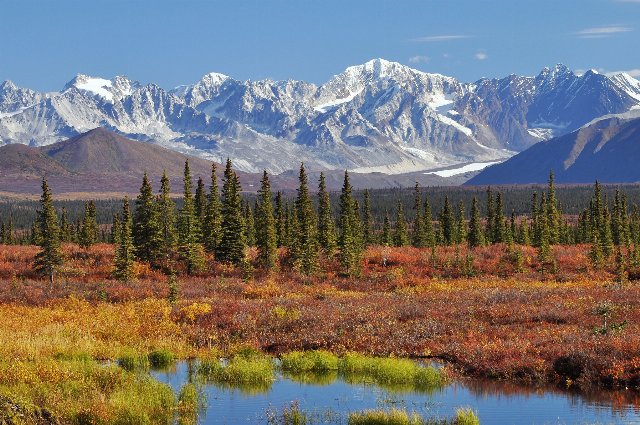 This photo shows the Alaska Range, one of the higher-elevation portions of the Boreal Cordillera. The highest elevations are covered in glaciers, with significant snow cover even at the end of the summer when this photo was taken. There are some trees, but much of the terrain features open tundra. The transition between open tundra and tree growth mediated by elevation, slope aspect, and presence or absence of permafrost is typical of this region. Photo © Paxson Woelber, CC BY 2.0, Source.
Plant Lists & In-Region Search
List Native Plants - List All Plants
Warning! This region extends outside the lower 48 US. We have only completed range maps for all plants in the lower 48 US; these lists and searches may thus have omissions for species which only occur in the portion of this region outside the lower 48 US.