
Home » Regions » North America » Northwestern Forested Mountains » Boreal Cordillera » Wrangell and St. Elias Mountains
Wrangell and St. Elias Mountains
Last updated: February 22nd, 2024
Page contents
↑About the Wrangell and St. Elias Mountains
The Wrangell and St. Elias Mountains are a series of mountain ranges located in southwestern Yukon and Southcentral Alaska. This region contains the greatest concentration of glaciers anywhere in North America, and is also home to some of the largest volcanoes, only one of which, Mount Wrangell at the northwesternmost end of this region, is active.The climate is subarctic and continental at the lowest elevations, reaching to a tundra climate over most of the region, and a few small zones of an ice cap climate at higher elevations. Temperatures in these ice cap zones never exceed freezing. The height of these mountains leads higher elevations to capture a great deal of moisture from the Pacific Ocean, which mostly falls as snow, but the more inland location leads this region to have less temperature moderation than coastal areas, and at lower elevations, precipitation is much lower here than in areas closer to the coast. Although precpititation loosely follows temperatures, there is a slight seasonal delay: the driest season comes in March-April, after the coldest season, and the wettest season comes August-September, after the hottest months.
The terrain consists of steep, rugged mountains of volcanic origin, covered with glaciers and extensive ice fields at high elevations. Snow accumulates at the high elevations and slowly travels down the glaciers to low elevations, where it melts and feeds streams. The depth of the ice exceeds 2,000 feet in places. The surface of the ice fields is much flatter than the terrain it covers; the slopes of the mountaintops rising out of the ice are gentler than the steep slopes of the U-shaped valleys where glaciers have retreated. Peaks reach to some of the higher, but not highest elevations in North America; Mount Lucania is the highest peak located within this region, at 17,257 ft (5260m.) Avalanches and landslides are common. Most surfaces that are not covered by frost or ice are covered in colluvium.
There is discontinuous permafrost throughout the region, which leads to structures such as ice-wedge networks, solifluction (material moving downhill pushed by freeze-thaw action) and other periglacial features. Soils here are mostly eutric brunisols, and tend to be thin, rocky, poorly-developed, and high in pH, reflecting the calcium rich rocks occurring at the lower elevations here, the only portions of this region with much exposed soil.
There is a moderate density of small streams, including both those originating as glacial melt and those originating on unglaciated slopes around the margins of the region; these streams of different origins combine in the larger valleys. In most of the region, streams flow north, ultimately into the Yukon river which empties into the Bering Sea; the southwest of this region drains into the Copper river, flowing through the Copper Plateau and into the Pacific. A small region in the far southeast of this region drains south into the Tatshenshini river, which also flows into the Pacific.
Most of this region is unvegetated. The ice cap zones are too cold for plant growth, even in areas where bedrock is exposed; even in the relatively more moderate tundra regions, much of the area is covered by ice fields. Vegetation is mostly found around the margins of this region. The harshest vegetated sites have rock outcroppings reaching through the ice, supporting lichens and isolated plants. Richer sites, usually in low-elevation valleys or on slopes of isolated peaks topographically sheltered from glaciation, support alpine tundra vegetation of heather, dwarf birch, willow, and various herbs, with scattered white spruce and alder. Wet sites support cottongrass and sedges. Most of the plant species found here are predominately found farther inland, as most of this region borders inhospitable mountains towards the coast, and a warmer, milder, more plant-rich area farther inland, although there is a small corridor along the Tatshenshini River that provides a path through which more coastal plant species have been able to spread into this region. The Copper River provides another such corridor, but it passes through less-hospitable areas and as such fewer plants have colonized this region through that pathway.
Land use here is sparse and mostly limited to recreational activities, with a small amount of mineral mining. There are abandoned mines scattered throughout, which can pose hazards to visitors. Much of the region is uninhabited and not even accessible by roads. The largest permanent settlement here is McCarthy, Alaska, an unincorporated town with a fluctuating population that has barely reached over 100, located at the edge of the Copper Plateau. A large portion of this region consists of public protected land, including Wrangell-St. Elias National Park & Preserve, Kluane National Park and Reserve, and a small portion of Tatshenshini-Alsek Provincial Park at the far south end of the region. The Kluane First Nation, which is mostly based outside this region near Burwash Landing, includes regions in the slopes on the margins of this region, with the mountains marking one of the boundaries of their traditional territory.
This region is bordered to the southwest and south by the Pacific Coastal Mountains, a similar mountain range reaching to even higher elevations, but with a more ocean-moderated climate; the border itself is subjective and ill-defined in most places, covered in ice fields. However in the northwest, the border is cleanly marked by the Copper River valley. In the northwest of this region, it is surrounded to the southwest, west, and northwest by the Copper Plateau, a lower-elevation region characterized by poor drainage and cold air drainage. The northernmost portion of this region has a small border to the north with the Alaska Range, another inland mountain range, but one separated from the coastal mountains by a greater distance and more well-defined geographic borders. The actual border between this and the Alaska range is somewhat subjective, but occurs in an area of relatively lower-elevation, warmer temperatures, a lack of ice, and wider valleys between the mountains. The southernmost end of this region is bordered to the east by the Yukon-Stikine Highlands/Boreal Mountains and Plateaus; the exact border between these regions is also subjective. Much of the region is bordered to the northeast by the Watson Highlands, and north of that, to the northeast by the Interior Highlands and Klondike Plateau. There is an even smaller border north of that, to the northeast with the Interior Bottomlands. All of these regions are lower-elevation and warmer.
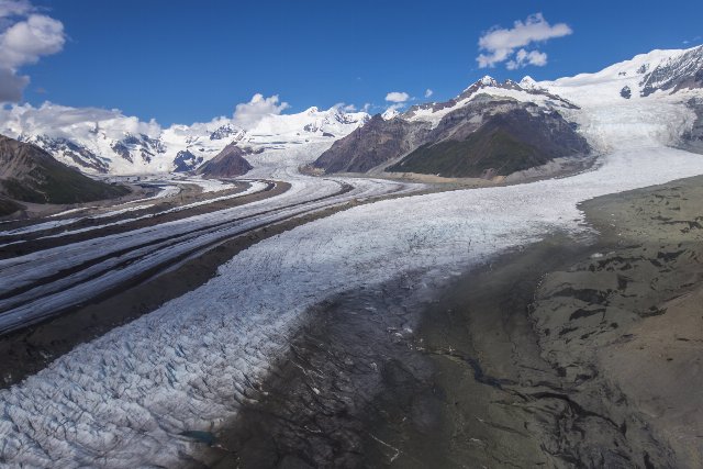 This photo, taken in the summer, shows the confluence of the Gates and Kennicott Glaciers in the Wrangell Mountains, Alaska, located upstream from McCarthy, one of the few permanent settlements in this region. This landscape is typical of mid-elevations here, showing the transition from lifeless ice fields at high elevations, to lower elevations where there is more exposed soil. Even here, plants can only survive on a small portion of the landscape, where the topography shelters the land from glaciation. Photo © U.S. National Park Service, Alaska, Public Domain, Source.