
Home » Regions » North America » Eastern Temperate Forests » Mixed Wood Plains » Lake Erie Lowland
Lake Erie Lowland
Last updated: November 15th, 2023
Page contents
↑About the Lake Erie Lowland
The Lake Erie Lowland is a region of land located north of Lake Erie, west of Lake Ontario, and south of Lake Huron; it is the southernmost region in Ontario (and all of Canada), and also the most intensely-developed region of Canada; it extends farther north on its east end, to just past Toronto; on its western end it extends north to the town of Grand Bend. Pelee Island, in Lake Erie, is also included in this region.The climate is humid and continental, with significant influence from the Great Lakes. The region straddles the border between a hot-summer climate in the southwest, and a warm-summer climate in most of the region, although Toronto's urban heat island effect pushes it into the hot summer zone as well. There are well-defined seasons, and although the climate averages humid year-round, the continental location, surrounded by large, flat expanses, can lead there to be major swings of temperature from day to day, and hot, cold, wet, or dry spells at any time of year. Precipitation tends to be roughly equally distributed throughout the year, with lower rainfall-equivalents in winter being balanced by colder temperatures. The proximity to the lakes moderates temperatures relative to locations at similar latitudes but farther from water. There is only minimal lake-effect precipitation, due to the elevations here being barely higher than the lakes. Because of the shape of the coastlines and the west-to-east motion of most weather systems, lake effect precpitation is highest along Lake Huron, but it is not as high as areas farther north that have Lake Huron directly to the west.
Lake Erie tends to freeze over completely in most winters, whereas Lake Ontario, which is much deeper, rarely freezes, and Lake Huron is somewhere in between the two; this leads the northeasternmost portion of the region, more influenced by Lake Ontario, to have lake influence persisting through the entire winter, whereas the southwesternmost portions of the region are slightly drier and sunnier in late winter.
This region was entirely glaciated, and most of this region is almostly completely flat; there are a few steep-walled outwash channels. The Grand River flows through one of these channels. The bedrock here is buried in most places beneath other deposits, including glacial moraine, and deposits of lake and/or marine origin, and bedrock outcroppings are rare. Elevations of the lakes vary considerably; Lake Huron is at 577 feet above sea level, Lake Erie not far below at 569 feet, but Lake Ontario is dramatically lower, at 243 feet; the result is that there is more rugged terrain here descending to Lake Ontario than in areas descending to the other two lakes.
When glaciers retreated, this region was exposed early and thus the lacustrine deposits are mostly concentrated in areas near the existing lakes. There are a number of streams and rivers which flow in various directions into the lakes. Soils tend to mostly be either humic gleysols, which are fertile but poorly-drained, or gray brown luvisols, which tend to be loamy and high in calcium. Aside from the poor drainage of some soils, the soils here tend to be ideal for agriculture.
This region is high in plant biodiversity, but has no endemic plants. Many plant species reach their northernmost range limits here, and there are numerous southerly species that are present but uncommon here, and absent from most other areas equally far north. Prior to European colonization, this region was almost entirely covered in forests, with dominant trees including sugar maple (Acer saccharum), American beech (Fagus grandifolia), white oak (Quercus alba) and northern red oak (Quercus rubra), shagbark hickory (Carya ovata), eastern black walnut (Juglans nigra), and butternut (Juglans cinerea). Wetter, poorly-drained sites, common throughout, supported American elm (Ulmus americana), eastern cottonwood (Populus deltoides), balsam poplar (Populus balsamifera), green ash (Fraxinus pennsylvanica), black ash (Fraxinus nigra), and silver maple (Acer saccharinum). Drier sites, which were relatively uncommon, featured black oak (Quercus velutina), chestnut oak (Quercus montana), and chinquapin oak (Quercus muehlenbergii); these three oak species are all near their northermost range limits here. Steep slopes, again uncommon here, featured tuliptree (Liriodendron tulipifera), American sycamore (Platanus occidentalis), and bitternut hickory (Carya cordiformis).
Nowadays the overwhelming majority of land here has been cleared, mostly for agriculture (occupying about 65% of the land), and a smaller but significant portion for urban development. Development here has been facilitated by the flat terrain, relatively moderate climate, and fertile soils. However, there are patches of wild forest throughout, both as small woodlots in predominately agricultural regions, and larger expanses. Even though these patches represent a small total portion of the region, they have been important for preserving the local flora. Cropland here produces corn, soybeans, tobacco, and fruit, including grapes for vineyards. The urban areas have both extensive residential, commercial, and industrial development. There are also significant areas of wetlands, particularly along Lake Erie. Most of these were historically channelized in attempts to drain them, and have only partially recovered from this channelization. There are some small areas of public protected land in the forms of parks and nature preserves, protecting both forests and wetlands. Forest composition has remained relatively similar, except that butternut has been mostly eliminated by blight, and more recently, black and green ash hugely reduced in extent by the introduced Emerald Ash Borer. This region also has a higher portion of invasive plant species than most of Canada, owing largely to the urbanization which has been associated with a higher rate of planting of exotic species.
This area is the most populous region in Canada, containing the metro area of Toronto, with over 6 million people, as well as the medium-sized cities of Hamilton, London, and the city of Windsor, part of the Detroit metro area, and the smaller cities of St. Catharines, Niagara Falls, and Sarnia. There is also a high density of small towns throughout the rural portions of this region.
Although much of this region is bordered by lakes, the borders of this region with neighboring pieces of land are mostly arbitrary and subjective. To the north and east, this region is bordered by the Eastern Great Lakes Lowlands; the northern border is on land, and represents a gradual transition to a colder climate. The eastern border is marked by the Niagara River. To the west, this region is bordered by the Huron/Erie Lake Plains; this border is marked by the St. Clair river in the area north of Lake St. Clair, and the Detroit river south of it. These borders marked by rivers are also rather arbitrary; the climate and geology are similar on both banks of each of these rivers.
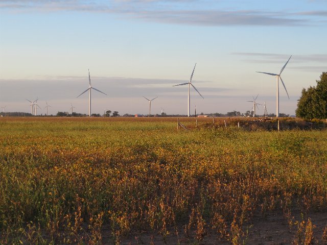 This flat landscape in southern Ontario shows cropland interspersed with a wind farm; patches of trees are visible on the horizon and on the right side of this picture, reflecting the fact that scattered woodlots and other small forests are scattered throughout even the more intensively agricultural portions of this region. Photo © Ken Lund, CC BY-SA 2.0, Source.