
Home » Regions » North America » Eastern Temperate Forests » Southeastern USA Plains » Piedmont » Talladega Upland
Talladega Upland
Last updated: March 19th, 2021
Page contents
↑About the Talladega Upland
The Talladega Upland contains the highest-elevation parts of the southern end of the Piedmont. It extends from western Georgia southwest into eastern Alabama, and tends to be widest near the border of these two states and narrower at its ends.This region has several different types of terrain: parts of it are a rugged, heavily-dissected plateau; other regions are flatter, with open, high hills, and there are also some long ridges running northeast to southwest, some of which reach to the highest elevations here. The underlying bedrock here is distinct from the surrounding regions: a mix of phyllite, quartzite, sandstone, and metaconglomerate. The soils here tend to be highly-leached red clay soils, suitable for forestry but not most forms of Western agriculture.
This region was originally covered mostly in oak-hickory-pine forest, but it also contained some unique areas of montane longleaf pine (Pinus palustris), a species mostly limited to the coastal plain.
Presently this region is mostly forested, with a mix of wild forests and pine plantations. There is a large amount of protected public land here, mostly in Alabama, including Talladega National Forest, and the smaller Cheaha State Park. The area is mostly utilized for forestry and recreation. The area is sparsely populated, with the largest town being Heflin, AL.
Along its entire length, this region is bordered to the southeast by the Southern Inner Piedmont, which tends to be lower elevation and less rugged. To the northwest, this region is bordered by the Ridge and Valley system of the Appalachians: in most places the border is with the low, flat, agriculturally-fertile Southern Limestone/Dolomite Valleys and Low Rolling Hills, but there is a small area where it borders the higher-elevation, forested Southern Sandstone Ridges, which consist mostly of unbroken ridges and less-dissected terrain, and which reach to higher elevations where they borders this region. At the far northeast, there is a small border to the north with the Southern Metasedimentary Mountains that marks the beginning of the Blue Ridge.
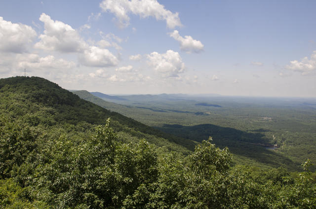 Cheaha Mountain, shown here, is the highest peak in the Talladega Uplands; the landscape of low, forested mountains is typical of the region. Photo © Brian Collins, CC BY 2.0, Source.
Plant Lists & In-Region Search
We do not yet have data to generate plant lists for a region as fine-tuned as this one. However you can move up to the broader Piedmont and generate lists for that region: native plants or all plants. Or search that region's plants here:
↑References
1. Griffith, G.E., Omernik, J.M., Comstock, J.A., Lawrence, S., Martin, G., Goddard, A., Hulcher, V.J., and Foster, T. "Ecoregions of Alabama and Georgia (color poster with map, descriptive text, summary tables, and photographs)", U.S. Geological Survey, Reston, VA (2001) Web.