
Home » Regions » North America » Eastern Temperate Forests » Ozark, Oauchita-Appalachian Forests » Ridge and Valley
Ridge and Valley
Last updated: February 24th, 2021
To check where a specific point lies, you can look it up in our Ecoregion Locator.
↑Map Legend & Subregion List
This list will help you navigate the regions in case you have problems with viewing or clicking the interactive map above.
† Status: ✓ = Complete ○ = Needs Image … = Incomplete ∅ = Stub Only
‡ This code refers to the US EPA's Level 4 ecoregion codes for the continental U.S., see here.
↑Progress
Partially Complete | With Images | Complete w/ Images |
Get involved! You can help our ecoregion articles progress faster. Help us find photos of these regions. Contact us if you have any additions or corrections to any of these articles. You can also donate to support our ongoing work.
↑About the Ridge and Valley
The Ridge and Valley region is a diverse region stretching northeast and southwest along almost the entire length of the Appalachian mountains. In all but a few places it is wedged between areas of higher altitude both to southeast and northwest. It contains all but the northernmost parts of the Great Appalachian Valley, a low-lying region running the entire length of the Appalachians, but also includes smaller valleys, many of which which that do not extend as far.The northeasternmost portion of this region was recently glaciated, but most of it has never been glaciated. This region can be coarsely divided into three sections: the northeasternmost glaciated portion, the unglaciated northern portion, and the southern portion. The border of glaciation is abrupt and well-defined, whereas the distinction between the northern and southern portions is more gradual and corresponds to changes in forest type associated with climate.
The terrain is relatively low-lying and flatter than most of the Appalachians, with long ridges and valleys and rolling hills, mostly oriented northeast-southwest. The region is underlain mostly by sedimentary rocks, including the more resistant sandstone and conglomerate, the erodable but less permeable shale, and the more water-soluble limestone and dolomite. Due to a history of folding and fault-lines, the underlying geology is irregular, and many different substrates can exist within a small area. The different properties of these rocks contribute to the varied topography in this area. Drainage follows a trellis pattern, in which small, fast-moving streams drain off ridges to join larger, lower-gradient streams flowing through the valleys. Springs and caves are common, following the distribution of limestone and dolomite.
This region has a humid continental climate in the north, and a humid subtropical climate in the south; because it covers such a long distance, there is a significant difference in the severity of winters and length of the growing season between its southern and northern ends. In general, the lower elevations make the climate here among the warmest in the Appalachians, especially in the areas where this region is dominated by low, flat valleys. At the southernmost end, where this region opens up to the Southeastern Plains, and also near the Maryland-West-Virginia border where the Blue Ridge is thinnest, the climate in the valleys is virtually indistinguishable from the bordering lowland regions. In Virginia however, where the Blue Ridge is taller, the Central Appalachians rise to the northwest, and this region is narrower, the climate here is relatively cooler, although still warmer than surrounding high-elevation regions.
Before European settlement, this area was covered with Appalachian oak forest in the north and Oak-Hickory-Pine forest in the south. This area is one of the regions of the Appalachians most heavily utilized for agriculture, particularly in the valleys. Dairy farming and beef cattle are important here, and there is some production of corn, soybeans, and tobacco, with some cotton farming in the south. There are some pine plantations as well, although this area is less utilized for forestry than flatter areas southeast of the Appalachians.
Owing to the flatter topography here, this area has more urban development than the other Appalachian regions surrounding it, although the urban areas are mostly smaller. Most of these cities have a history of industry and have experienced significant economic decline as part of the rust belt.
Most of this region is bordered to the southeast by the Blue Ridge, although in part of Pennsylvania this region opens up directly onto the Northern Piedmont to the southeast. To the northwest, this region is bordered by the Southwestern Appalachians in the south, the Central Appalachians farther north, and the North Central Appalachians at the farthest north points. The northeasternmost end of this region borders the Northeastern Highlands, whereas the southernmost end opens up onto the Piedmont and Southeastern Plains.
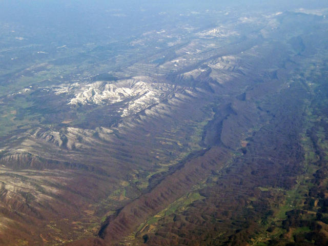 This aerial photo shows the Ridge & Valley system close to its center. The long, unbroken ridge is sandstone; to the left are dissected ridges & knobs. The lower areas contain shale valleys with more rugged terrain and forest cover, and limestone/dolomite valleys which are flatter and have more agriculture. This is one of the more rugged parts of the Ridge & Valley system; in areas it is much lower and flatter. Crop of a photo © James St. John, CC BY 2.0, Source.
Plant Lists & In-Region Search
↑References
1. Woods, A.J, Omernik, J.M., Brown, D.D. "Level III and IV Ecoregions of Delaware, Maryland, Pennsylvania, Virginia, and West Virginia", U.S. Environmental Protection Agency: National Health and Environmental Effects Research Laboratory, Corvallis, OR (1999) Web.
2. Wiken, E., Griffith, G. "North American Terrestrial Ecoregions - Level III", Commission for Environmental Cooperation, (2011) Web.