
Home » Regions » North America » Eastern Temperate Forests » Ozark, Oauchita-Appalachian Forests » Ridge and Valley » Southern Sandstone Ridges
Southern Sandstone Ridges
Last updated: December 8th, 2020
↑About the Southern Sandstone Ridges
The Southern Sandstone Ridges region represents the more southerly counterpart of the Northern Sandstone Ridges, both of which live within the Ridge and Valley system of the Appalachians. Although these two regions have the same underlying geology, they are differentiated by a fairly well-defined change in forest type due to climate. This region extends from western Virginia southwest through Tennessee and Georgia, into northern Alabama, but it is much thinner in Tennessee and Georgia, and most of its area is within Virginia and Alabama.This region consists of long ridges with flat, mostly unbroken tops, and heavily-dissected side-slopes. The highest elevations consist of erosion-resistant sandstone and conglomerate, whereas side-slopes also contain more easily erodible shale and siltstone. Drainage follows a trellis pattern, with numerous small streams draining perpendicular to the ridges, into narrow valleys with slightly larger streams running parallel to the ridges. However, in a few places, such as along the Cahaba river in the south of this region, the terrain has become more dissected. On ridgetops, soils can be thin, with extensive bedrock outcroppings. Even where soils are deeper, soils here tend to be leached, acidic, and nutrient-poor.
This region was originally covered mostly by Appalachian oak forest or mixed oak forest, with American chestnut (Castanea dentata), chestnut oak (Quercus montana), black oak (Quercus velutina), scarlet oak (Quercus coccinea), northern red oak (Quercus rubra), white oak (Quercus alba), and various other oaks, some hickory, pine, poplar, birch, and red maple (Acer rubrum). In Tennesee, there was also some mixed mesophytic forest, featuring American beech (Fagus grandifolia), tuliptree (Liriodendron tulipifera), various oaks, buckeye, and American basswood (Tilia americana). The southernmost portion of this region supported oak-hickory-pine forest on the drier sites. There were also open barrens on the rockiest sites.
Nowadays this region is mostly forested. American chestnut has been nearly eliminated by the blight. There is a small amount of cropland and pastureland in the narrow valley bottoms. Although much of this region is sparsely populated, the southernmost portion of this region has a significant amount of suburban development, especially in the area near Birmingham, AL where elevations are lower and the ridges are more eroded; the largest such suburb is the city of Hoover, AL, a municipality with irregular borders but that is nonetheless mostly centered within this region.
This region is mostly surrounded by the Southern Limestone/Dolomite Valleys and Low Rolling Hills, a lower, flatter area that has more fertile soils and is more extensively farmed. There are also some borders with the Southern Shale Valleys, another low-lying region with poorer soils. In a few places, it also borders the Southern Dissected Ridges and Knobs, a region with more broken ridges and isolated peaks.
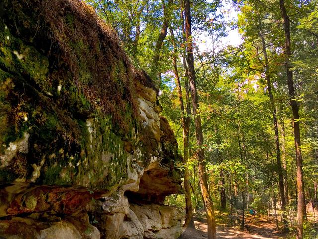 Moss Rock Preserve in Hoover, Alabama is located within the Southern Sandstone Ridges; these ridges have steep faces and in places have thin soils and bedrock outcroppings, leading to more open forest like pictured here. Photo © Andy Montgomery, CC BY 2.0, Source.
Plant Lists & In-Region Search
We do not yet have data to generate plant lists for a region as fine-tuned as this one. However you can move up to the broader Ridge and Valley and generate lists for that region: native plants or all plants. Or search that region's plants here:
↑References
1. Woods, A.J, Omernik, J.M., Brown, D.D. "Level III and IV Ecoregions of Delaware, Maryland, Pennsylvania, Virginia, and West Virginia", U.S. Environmental Protection Agency: National Health and Environmental Effects Research Laboratory, Corvallis, OR (1999) Web.
2. Griffith, G.E.; Omernik, J.M.; and Azevedo, S.H. "Ecoregions of Tennessee (Poster)", U.S. Geological Survey, Reston, VA (1998) Web.
3. Griffith, G.E., Omernik, J.M., Comstock, J.A., Lawrence, S., Martin, G., Goddard, A., Hulcher, V.J., and Foster, T. "Ecoregions of Alabama and Georgia (color poster with map, descriptive text, summary tables, and photographs)", U.S. Geological Survey, Reston, VA (2001) Web.