
Home » Regions » North America » Northern Forests » Atlantic Highlands » Northeastern Highlands » Northern Connecticut Valley
Northern Connecticut Valley
Last updated: November 13th, 2021
Page contents
↑About the Northern Connecticut Valley
The Northern Connecticut Valley is a long, narrow region extending along the floodplains and terraces along the Connecticut river, which forms the border of Vermont and New Hampshire. It can be seen as a northern extension of the broader Connecticut Valley to the south; this northern portion is distinguished by its narrow width, more northerly location, and being surrounded by mountains to both east and west.This region consists mostly of floodplains and low terraces from when the river was slightly higher. There are some glacial outwash and glacial lake deposits at the base of the hills lining the region. The areas of glacial lake deposits are finer-textured than the coarser sands and gravels found over much of this area. The region has a humid continental climate, markedly milder than the higher-elevation areas to the east and west, but also markedly colder than the broader, open parts of the Connecticut Valley to the south.
The coarse-textured soils create more opportunties for drought-adapted species than is typical for a river valley in such a humid climate. Many southerly plant species extend up through this valley, but are absent from the cooler, higher-elevation regions farther from the river.
Original forest cover here was among the most diverse of any areas in the surroundings. Slightly drier sites featured Appalachian oak-hickory forest, with white oak (Quercus alba), black oak (Quercus velutina), and https://bplant.org/plant/172, shagbark hickory (Carya ovata), pignut hickory (Carya glabra), eastern white pine (Pinus strobus), sweet birch (Betula lenta), and red maple (Acer rubrum). Richer sites on terraces featured sugar maple-oak-hickory forest, with sugar maple (Acer saccharum), white ash (Fraxinus americana), https://bplant.org/plant/124, American basswood (Tilia americana), butternut (Juglans cinerea), eastern hemlock (Tsuga canadensis), northern red oak, white oak, shagbark hickory, various birches, and red maple. There were also areas of northern hardwood forest, with American beech (Fagus grandifolia), yellow birch (Betula alleghaniensis), sugar maple, and some red maple, white ash, and American basswood. Eastern hemlock was often a co-dominant addition to the northern hardwood forest association. There were also some smaller areas of pine-oak-heath sandplain forest, featuring pitch pine (Pinus rigida), eastern white pine, red maple, black oak, and northern red oak. Wetlands included alder swamps, cattail marshes, sedge meadows, and floodplain forests with silver maple (Acer saccharinum) and ostrich fern (Matteuccia struthiopteris).
This area has been heavily altered from its original state, much more so than most regions of Vermont and New Hampshire. There is extensive agriculture, often extending almost the whole way the river, leaving only a narrow strip of trees. The valley also serves as a transportation corridor, with I-91 and US-5 moving through it over much of its length, and various state roads on the New Hampshire side. There is also significant urbanization, as small towns and commerce tend to concentrate both along roads and near the greater agriculture. The river itself has also been altered by damming in multiple locations, the largest two of which are the Moore and Comerford dams in the north of this region where the river curves more east-west; these dams created two large reservoirs. Besides damming, the river has also been altered by channelization.
There is some forest cover here, but it is disproportionately located along the more upland margins of this area. Much less of the unique bottomland forests remain, and those that do are often highly fragmented by agriculture and roads.
Along most of its length, this region is surrounded both to the west and east by the Vermont Piedmont. North of that, it is bordered to the west by the Northern (Vermont) Piedmont and to the east by the White Mountain Foothills. At the northern end it is surrounded both to the west and east by the Quebec/New England Boundary Mountains. At the south it opens up onto the main portion of the Connecticut Valley.
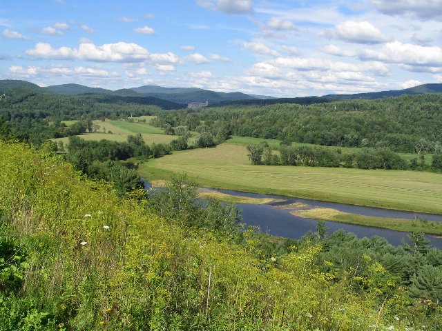 This photo shows the Connecticut River Valley, as seen from Interstate 91 in Vermont, looking across towards New Hampshire. This scenery is typical of the Northern Connecticut Valley in Vermont and New Hampshire: the valley is narrow, consisting of some floodplains and low terraces, and there is considerable agriculture. Photo © Ken Lund, CC BY-SA 2.0, Source.
Plant Lists & In-Region Search
We do not yet have data to generate plant lists for a region as fine-tuned as this one. However you can move up to the broader Northeastern Highlands and generate lists for that region: native plants or all plants. Or search that region's plants here:
↑References
1. Griffith, G.E., Omernik, J.M., Bryce, S.A., Royte, J., Hoar, W.D., Homer, J.W., Keirstead, D., Metzler, K.J., and Hellyer, G. "Ecoregions of New England (Poster)", U.S. Geological Survey (2009) Web.